Nov 22, 2019

Lonar Lake, Buldhana district, Maharashtra, India

Lonar Lake, also known as Lonar crater, is a notified National Geo-heritage Monument, saline, soda lake, located at Lonar in Buldhana district, Maharashtra, India. Lonar Lake was created by an asteroid collision with earthimpact during the Pleistocene Epoch. It is one of the four known, hyper-velocity, impact craters in basaltic rock anywhere on Earth. The other three basaltic impact structures are in southern Brazil. Lonar Lake has a mean diameter of 1.2 kilometres (3,900 ft) and is about 137 metres (449 ft) below the crater rim. The meteor crater rim is about 1.8 kilometers (5,900 ft) in diameter.

Lonar Crater sits inside the Deccan Plateau a massive plain of volcanic basalt rock created by eruptions some 65 million years ago. Its location in this basalt field suggested to some geologists that it was a volcanic crater. Today, however, Lonar Crater is understood to be the result of a meteorite impact that occurred between 35,000 and 50,000 years ago. The water in the lake is both saline and alkaline.

Geologists, ecologists, archaeologists, naturalists. and astronomers have published studies of various aspects of this crater lake ecosystem. the crater's age is usually estimated to be 52,000 ± 6,000 years, although a study published in 2010 gives an age of 570,000 ± 47,000 years. The Smithsonian Institution, the United States Geological Survey, Geological Survey of India, the University of Sagar and the Physical Research Laboratory have conducted extensive studies of the site. Biological nitrogen fixation was discovered in this lake in 2007. A recent study, conducted by IIT Bombay found that the minerals, in the lake soil, are very similar to the minerals found in moon rock brought back during Apollo Program.


The water of the lake contains various salts and sodas. During dry weather, when evaporation reduces the water level, large quantities of soda are collected. Two small streams, named Purna and Penganga, drain into the lake, and a well of fresh water is located on the southern side, close to the water's edge.

Lonar Lake lies within the only known extraterrestrial impact crater found within the great Deccan Traps, a huge basaltic formation in India. The lake was initially believed to be of volcanic origin, but now it is recognized as an impact crater. Lonar Lake was created by the impact of either a Comet or of an Asteroid. The presence of plagioclase that has been either converted into Maskelynite or contains Planar deformation features has confirmed the impact origin of this crater. It is believed that only shock metamorphism caused by a hypervelocity impact can transform plagioclase into maskelynite, or create planar deformation features. The presence of impact deformation of basalt layers comprising the rim, of shocked Breccia inside the crater, of shatter cones, and of the non-volcanic Ejecta blanket surrounding the crater all support the impact origin of Lonar Lake.

The crater has an oval shape. The meteorite impact came from the east, at an angle of 35 to 40 degrees.There are various estimates of the age of the crater. Earlier thermoluminescence analyses gave a result of 52,000 years, while recent Argon-argon dating suggests that the crater is much older; it could be 570 000 ± 47 000 years old. This greater age is in line with the degree of erosion of the crater rim.
For more information - Lonar Lake  

Nov 17, 2019

Takachiho Gorge, Japan

Takachiho Gorge  is a narrow chasm cut through the rock by the Gokase River. The nearly sheer cliffs lining the gorge are made of slow forming volcanic basalt columns which resemble the scales of a dragon where the stone twisted and flowed as it formed.

Partway along the gorge is the 17 meter high Minainotaki waterfall cascading down to the river below, and it is truly impressive to see the waterfall against a backdrop of dense green foliage and the surrounding grey cliffs.


There are two perspectives from which to enjoy the gorge. The first is from below which is done by rowing down the river. Rental boats are available at the south end of the gorge, and the water is calm and easy to navigate. This highly recommended route offers a close up view of the cliffs and waterfall.

The second perspective, from above, is done by walking the paved path that runs along the edge of the gorge. There are beautiful views all along the way and at some points on the trail you can look practically straight down to the river below. The trail continues for about one kilometer, eventually leading to the Takachiho Shrine. There are a few other things to see and do around the southern end of the gorge including a freshwater aquarium, a stocked fishing pond and a few restaurants and souvenir shops.

Nov 16, 2019

Olympic National Park, State of Washington, USA

Olympic National Park is an American national park located in the State of Washington, on the Olympic Peninsula. The park has four regions: the Pacific coastline, alpine areas, the west side temperate rain forest and the forests of the drier east side. Within the park there are three distinct ecosystems which are sub alpine forest and wildflower meadow, temperate forest, and the rugged Pacific coast.

President Theodore Roosevelt originally designated Mount Olympus National Monument on 2 March 1909. The monument was redesignated as a national park by Congress and President Franklin Roosevelt on June 29, 1938. In 1976, Olympic National Park was designated by UNESCO as an International Biosphere Reserve, and in 1981 as a World Heritage Site. In 1988, Congress designated 95 percent of the park as the Olympic Wilderness.


The coastal portion of the park is a rugged, sandy beach along with a strip of adjacent forest. It is 60 miles (97 km) long but just a few miles wide, with native communities at the mouths of two rivers. The Hoh River has the Hoh people and at the town of La Push at the mouth of the Quileute River live the Quileute. The beach has unbroken stretches of wilderness ranging from 10 to 20 miles. While some beaches are primarily sand, others are covered with heavy rock and very large boulders. Bushy overgrowth, slippery footing, tides and misty rain forest weather all hinder foot travel. The coastal strip is more readily accessible than the interior of the Olympics; due to the difficult terrain, very few backpackers venture beyond casual day-hiking distances.

The most popular piece of the coastal strip is the 9-mile Ozette Loop. The Park Service runs a registration and reservation program to control usage levels of this area. From the trailhead at Ozette Lake, a 3-mile (4.8 km) leg of the trail is a boardwalk-enhanced path through near primal coastal cedar swamp. Arriving at the ocean, it is a 3-mile walk supplemented by headland trails for high tides. This area has traditionally been favored by the Makah from Neah Bay. The third 3-mile leg is enabled by a boardwalk which has enhanced the loop's visitor numbers.

There are thick groves of trees adjacent to the sand, which results in chunks of timber from fallen trees on the beach. The mostly unaltered Hoh River, toward the south end of the park, discharges large amounts of naturally eroded timber and other drift, which moves north, enriching the beaches. The removal of driftwood – logs, dead-heads, tops and root-wads from streams and beaches was a major domestication measure across North America. Even today driftwood deposits form a commanding presence, biologically as well as visually, giving a taste of the original condition of the beach viewable to some extent in early photos. Drift-material often comes from a considerable distance; the Columbia River formerly contributed huge amounts to the Northwest Pacific coasts.

The smaller coastal portion of the park is separated from the larger, inland portion. President Franklin D. Roosevelt originally had supported connecting them with a continuous strip of park land. The park is known for its unique turbidites. It has very exposed turbidities with white calcite veins. Turbidites are rocks or sediments that travel into the ocean as suspended particles in the flow of water, causing a sedimentary layering effect on the ocean floor. Over time the sediments and rock compact and the process repeats as a constant cycle. The park also is known for its tectonic mélanges that have been deemed 'smell rocks' by the locals due to its strong petroleum odor. Mélanges are large individual rocks that are large enough that they are accounted for in map drawings. The Olympic mélanges can be as large as a house.

Within the center of Olympic National Park rise the Olympic Mountains whose sides and ridgelines are topped with massive, ancient glaciers. The mountains themselves are products of accretionary wedge uplifting related to the Juan De Fuca Plate subduction zone. The geologic composition is a curious mélange of basaltic and oceanic sedimentary rock. The western half of the range is dominated by the peak of Mount Olympus, which rises to 7,965 feet (2,428 m). Mount Olympus receives a large amount of snow, and consequently has the greatest glaciation of any non-volcanic peak in the contiguous United States outside of the North Cascades. It has several glaciers, the largest of which is Hoh Glacier at 3.06 miles (4.93 km) in length. Looking to the east, the range becomes much drier due to the rain shadow of the western mountains. Here, there are numerous high peaks and craggy ridges. The tallest summit of this area is Mount Deception, at 7,788 feet.

The western side of the park is mantled by temperate rain-forests, including the Hoh Rain-forest and Quinault Rain-forest, which receive annual precipitation of about 150 inches (380 cm), making this perhaps the wettest area in the continental United States.

As opposed to tropical rain-forests and most other temperate rainforest regions, the rainforests of the Pacific Northwest are dominated by coniferous trees, including Sitka Spruce, Western Hemlock, Coast Douglas-fir and Western redcedar. Mosses coat the bark of these trees and even drip down from their branches in green, moist tendrils. Valleys on the eastern side of the park also have notable old-growth forest, but the climate is notably drier. Sitka Spruce is absent, trees on average are somewhat smaller, and undergrowth is generally less dense and different in character. Immediately northeast of the park is a rather small rainshadow area where annual precipitation averages about 16 inches.

The park also provides habitat for many species that are native only to the Pacific Northwest coast. As a result, scientists have declared it a biological reserve and study its unique species to better understand how plants and animals evolve. The park is home to sizable populations of black bears and black-tailed deer. The park also has a noteworthy cougar population, numbering about 150. Mountain goats were accidentally introduced into the park into the 1920s and have caused much damage on the native flora. The NPS has activated management plans to control the goats.The park contains an estimated 366,000 acres of old-growth forests. Forest fires are infrequent in the rainforests of the park's western side; however, a severe drought after the driest spring in 100 years, coupled with an extremely low snowpack from the preceding winter, resulted in a rare rainforest fire in the summer of 2015.
There are several roads in the park, but none penetrate far into the interior. The park features a network of hiking trails, although the size and remoteness means that it will usually take more than a weekend to get to the high country in the interior. The sights of the rain forest, with plants run riot and dozens of hues of green, are well worth the possibility of rain sometime during the trip, although months of July, August and September frequently have long dry spells. An unusual feature of ONP is the opportunity for backpacking along the beach. The length of the coastline in the park is sufficient for multi-day trips, with the entire day spent walking along the beach. Although idyllic compared to toiling up a mountainside, one must be aware of the tide; at the narrowest parts of the beaches, high tide washes up to the cliffs behind, blocking passage. There are also several promontories that must be struggled over, using a combination of muddy steep trail and fixed ropes.

During winter, the viewpoint known as Hurricane Ridge offers numerous winter sports activities. The Hurricane Ridge Winter Sports Club operates Hurricane Ridge Ski and Snowboard Area, a not for profit alpine ski area which offers ski lessons, rentals, and inexpensive lift tickets. The small alpine area is serviced by two rope tows and one poma lift. A large amount of backcountry terrain is accessible for skiers, snowboarders, and other backcountry travelers when the Hurricane Ridge Road is open. Winter access to the Hurricane Ridge Road is currently limited to Friday through Sunday weather permitting. The Hurricane Ridge Winter Access Coalition is a community effort to restore seven-day-a-week access via the Hurricane Ridge Road. Rafting is available on both the Elwha and Hoh Rivers. Boating is common on Ozette Lake, Lake Crescent, and Lake Quinault.

For more information  - Olympic National Park

Nov 14, 2019

Glory Hole In Monticello Dam, California, United States

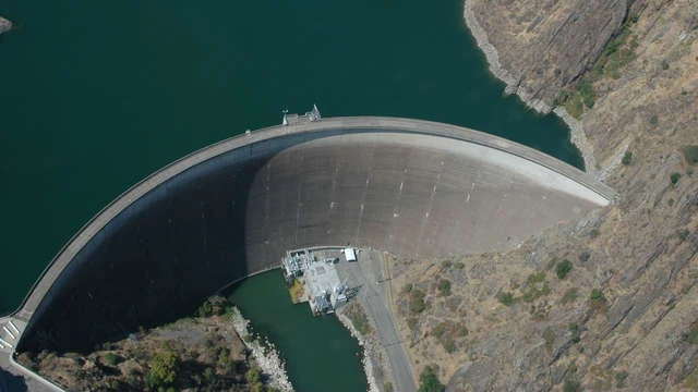
Monticello Dam is a 304-foot (93 m) high concrete arch dam in Napa County, California, United States constructed between 1953 and 1957. The dam impounded Putah Creek to create Lake Berryessa in the Vaca Mountains.

Lake Berryessa is currently the seventh largest man-made lake in California. Water from the reservoir primarily supplies agriculture in the Sacramento Valley downstream. The dam is noted for its classic, uncontrolled morning-glory-type spillway.The diameter at the lip is 72 ft (22 m). Locally, the spillway is also known as the "Glory Hole


Though the dam and its 26-mile (42 km) long reservoir are located entirely in eastern Napa County, the dam lies less than 500 ft (150 m) west of the boundary with Yolo County. In addition, parts of the lake's watershed extend into Lake County. Monticello is a concrete medium thick arch dam 304 ft (93 m) high from the foundations, 1,023 ft (312 m) long and 239 ft (73 m) above the riverbed. The dam is 100 ft (30 m) thick at the base, tapering to 12 ft (3.7 m) at the crest. The total volume of construction materials is 326,000 cubic yards.

The capacity of the reservoir is 1,602,000 acre⋅ft , with a full surface area of 20,700 acres (8,400 ha). The maximum operating elevation is 440 ft (130 m); any higher water levels will flow over the dam's spillway. About 375,000 acre feet of runoff flow into the reservoir each year from its 566-square-mile  watershed. The Monticello Dam Powerplant was completed in 1983 and has three generators, totaling a capacity of 11.5 megawatts (MW). The powerplant is operated and maintained by the Solano Irrigation District. The electrical power is sent mostly to the North Bay area of the San Francisco Bay Area.
 
As of 1992, about 71,445 acres, or nearly 75 percent, of the project command area was irrigated. Water is diverted 6 miles (9.7 km) downstream of Monticello at the Putah Diversion Dam, and distributed to farms through the 33-milePutah South Canal. The canal ends at Terminal Reservoir, which supplies water to the cities of Vallejo and Benicia. A 1999 contract provides for the delivery of 207,350 acre feet of water each year for irrigation. About 32,000 acre feet  of municipal water are also supplied by the project.Since construction the dam and reservoir have prevented about $5,015,000 in flooding related damages

The dam's morning-glory-type spillway, known as the Glory Hole, is 72 feet (22 m) in diameter at lake level and narrows down to about 28 feet (8.5 m) at the exit. At the lake's peak level, the spillway can drain 48,400 cubic feet per second, which occurs when the lake level rises to 15.5 feet (4.7 m) above the level of the funnel. Water spills over its lip when the lake reaches 1,602,000 acre feet and a reservoir elevation of 440 feet (130 m) above sea level. The last time the reservoir naturally spilled through the glory hole was on the afternoon of February 26, 2019.

Prior to that, the last time the spillway was active was February 16, 2017. After a number of storms had caused the lake level to rise 35.5 inches since January 1, 2017, the reservoir was on the cusp of spilling once again at 439.2 feet. Eager to witness this event, a number of local boaters and recreation enthusiasts generated enough wake to cause the reservoir to spill, albeit briefly, at 1:45 p.m. on February 13, 2017. Lake Berryessa reservoir filled and ran into its glory hole spillway for the first time in over a decade on February 16, 2017.

Sep 13, 2019

Indira Gandhi Memorial Tulip Garden (Asia Biggest Tulip Garden), Srinagar, Kashmir, India

Indira Gandhi Memorial Tulip garden is a tulip garden in Srinagar, Kashmir. It is the largest tulip garden in Asia spread over an area of about 30 hectares. It is situated on the foothills of Zabarwan Range with an overview of Dal Lake. The garden was opened in 2007 with the aim to boost floriculture and tourism in Kashmir Valley.

The garden is built on a sloping ground in a terraced fashion consisting of seven terraces. Apart from tulips, many other species of flowers - hyacinths, daffodils and ranunculus have been added as well.

A seven-terraced garden, Tulip Garden is also known as Indira Gandhi Memorial Tulip Garden after being known as Model Floriculture Center for a long time. The water channel running through the terraces adds more charm to the place. Sprawling in 30-hectares of land, this major tourist site in Srinagar comes to live during the spring season when the Tulip Festival is held annually. Opened to public, this festival aims at flaunting the natural beauty of the garden, the rich Kashmiri culture, and its handicraft and cuisine.


Tulip festival is an annual celebration that aims to showcase the range of flowers in the garden as a part of tourism efforts by the Government of Jammu and Kashmir. It is organized during the onset of spring season in Kashmir valley.There are some added attractions in the Tulip Festival of 2019. Nature has bestowed the garden with more varieties of flowers this year. Moreover, visitors can avail the benefits of surplus facilities like free Wi-Fi, more fountains, washrooms and drinking points.

More green spaces are included in the garden area keeping in mind the comforts of the tourists. Extra plants like daffodils, hyacinths, narcissus and other ornamental plants are planted to ornate the area. Water channel running through the terraces will add charm to the garden.

Visitors will now be able to buy souvenirs and savor Kashmiri dishes from outside the garden area. This will be possible because of the decorated stalls and kiosks exhibiting cuisine and handicrafts of Kashmir.