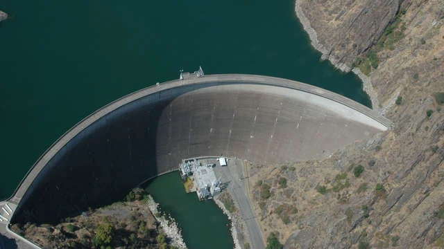
Monticello Dam is nestled in the picturesque landscape of Northern California, Monticello Dam is a remarkable feat of engineering that holds back the waters of Lake Berryessa, one of the largest reservoirs in the state. Completed in 1957, the dam stands as a testament to human ingenuity and provides vital resources to the region.
Location and Overview
Monticello Dam is located in Napa County, about 30 miles west of Sacramento. It is part of the Solano Project, a federal initiative managed by the Bureau of Reclamation, which supplies water for agriculture, municipal, and industrial use. The dam spans Putah Creek and is a key source of water for the Solano Irrigation District.
Technical Specifications
- Type: Concrete arch dam
- Height: 304 feet (93 meters)
- Length: 1,023 feet (312 meters)
- Base Thickness: 100 feet (30 meters)
- Reservoir Capacity: Approximately 1.6 million acre-feet
- Surface Area of Lake Berryessa: 20,700 acres
The dam’s curved design efficiently distributes water pressure, allowing it to withstand the enormous weight of Lake Berryessa. This design is particularly suited for the narrow gorge of Putah Creek.
The Glory Hole: A Unique Spillway
One of Monticello Dam's most iconic features is its morning glory spillway, commonly referred to as the Glory Hole. This giant, funnel-shaped structure acts as an overflow mechanism, preventing the reservoir from exceeding its capacity. The spillway has a diameter of 72 feet at its opening and narrows to 28 feet at the bottom. When water levels rise above 440 feet, the spillway creates a surreal whirlpool effect, drawing visitors and photographers from around the world.
Historical Background
The creation of Monticello Dam led to the inundation of the old town of Monticello, which once occupied the valley now submerged under Lake Berryessa. The town was a small but thriving agricultural community known for its orchards, ranches, and grain fields. Today, remnants of the town lie beneath the reservoir, a haunting reminder of the sacrifices made for progress.
Recreation at Lake Berryessa
Lake Berryessa, formed by the dam, is a recreational haven. Visitors can enjoy a wide range of activities, including:
- Boating
- Fishing (for species such as bass, catfish, and trout)
- Swimming
- Kayaking
- Camping
With its calm waters and stunning scenery, Lake Berryessa is a favorite getaway for outdoor enthusiasts in Northern California.
Environmental and Community Impact
While the dam has brought significant benefits, including flood control and a stable water supply, it has also altered the local ecosystem. The flooding of the valley displaced native wildlife and submerged fertile lands. However, ongoing conservation efforts aim to balance the needs of the environment with those of the community.
Visiting Monticello Dam
Monticello Dam is easily accessible by car, with parking and observation areas available for visitors. The view of the Glory Hole in action is particularly mesmerizing during periods of heavy rainfall when water flows into the spillway.
Fun Facts About Monticello Dam
- The Glory Hole has a flow capacity of 48,000 cubic feet per second.
- It gained international fame after viral videos showcased the whirlpool effect.
- The dam’s construction required over 326,000 cubic yards of concrete.
Monticello Dam and Lake Berryessa offer a fascinating blend of engineering brilliance and natural beauty. Whether you're an adventure seeker, a history buff, or simply looking for a peaceful retreat, this iconic landmark is a must-visit destination.


No comments:
Post a Comment
Stay updated with our blog for more quality content! Your feedback is appreciated. Contact us at harshrex@outlook.com with any suggestions.