Aug 13, 2019

Huacachina, (The Extraordinary Desert Oasis), Peru

Huacachina is a village in southern Peru, an hour away from the Pacific coast. The town is a collection of resorts and restaurants around a blue-green laguna surrounded by huge sand dunes. An antique image of the town is featured on Peru's 50 soles bill.

Huacachina is a village built around a small oasis and surrounded by sand dunes in southwestern Peru. It is about five kilometers from the city of Ica in the Ica District of Ica Province. The oasis was introduced as a feature on the back of the 50 nuevo sol note in 1991. Huacachina has a permanent population of around 100 people, although it hosts many tens of thousands of tourists each year.


Huacachina is built around a small natural lake in the desert. It is commonly referred to as the "oasis of America", it is a resort geared to local families from the nearby city of Ica, and increasingly as an attraction for tourists drawn by the sports of sand boarding on the sand dunes that stretch several hundred feet high. Other popular activities include dune buggy rides on buggies known locally as areneros.

According to local legends, the water and mud of the area is therapeutic. Both locals and tourists often bathe in the waters or cover themselves with the mud in an attempt to cure ailments such as arthritis, rheumatism, asthma and bronchitis.

Legend holds that the lagoon was created when a beautiful native princess removed her clothes to bathe, but after looking in a mirror she saw a male hunter approaching her from behind. Startled at the intrusion, she fled the area leaving behind her mirror which turned into a lake. Other versions hold that she fled, leaving the pool of water she had been bathing in to become the lagoon. The folds of her mantle, streaming behind her as she ran, became the surrounding sand dunes. The woman herself is rumored to still live in the oasis as a mermaid.


The lake was created by natural seepage from the underground aquifers, but the increase in well-drilling started to threaten that supply in the early 2000's. To compensate for this loss, and preserve the oasis as an destination for tourists, local business groups began pumping water into the lake in 2015.

It was announced in 2016 that the Peruvian scientist Marino Morikawa, who created a nanobubble system to decontaminate lake El Cascajo, will lead a project to restore the Huacachina lagoon.

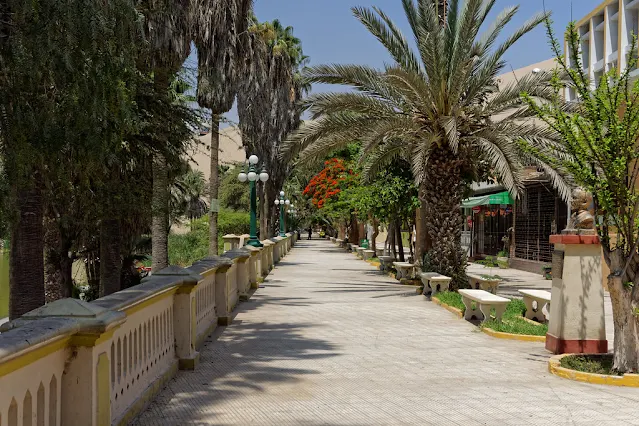
Near the entrance to the Huacachina promenade are kiosks that sell souvenirs, jewelry, t-shirts and other touristy knicknacks. Others sell tasty jams made from fruits in the area  and some liqueurs from Ica such as pisco and wine. Apart from these small shops, there are only tiny convenience stores. Virtually all items are more expensive than when purchased in Ica. The only ATM in the town is at the Carola Lodge. It frequently is out of cash. Ica, a few kilometers away, has a number of ATM machines, and money-changers who will convert your dollars into soles and vice versa in exchange for a small commission.

Lake Natron, Arusha Region, Tanzania

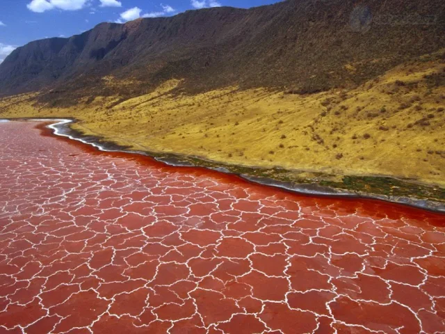
Lake Natron is a salt or soda lake in Arusha Region in Tanzania. It is in the Gregory Rift, which is the eastern branch of the East African Rift The lake is within the Lake Natron Basin, a Ramsar Site wetland of international significance.

The lake is fed principally by the Southern Ewaso Ng'iro River, which rises in central Kenya, and by mineral-rich hot springs. It is quite shallow, less than three meters (9.8 ft) deep, and varies in width depending on its water level. The lake is a maximum of 57 kilometers (35 mi) long and 22 kilometers (14 mi) wide. The surrounding area receives irregular seasonal rainfall, mainly between December and May totaling 800 millimeters (31 in) per year. Temperatures at the lake are frequently above 40 °C (104 °F).

High levels of evaporation have left behind natron (sodium carbonate decahydrate) and trona (sodium sesquicarbonate dihydrate). The alkalinity of the lake can reach a pH of greater than 12. The surrounding bedrock is composed of alkaline, sodium-dominated trachytelavas that were laid down during the Pleistocene period. The lavas have significant amounts of carbonate but very low calcium and magnesium levels. This has allowed the lake to concentrate into a caustic alkaline brine.


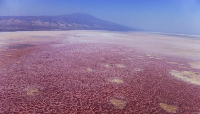
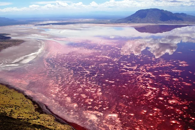
The color of the lake is characteristic of those where very high evaporation rates occur. As water evaporates during the dry season, salinity levels increase to the point that salt-loving microorganisms begin to thrive. Such halophile organisms include some cyanobacteria that make their own food with photosynthesis as plants do. The red accessory photosynthesizing pigment in the cyanobacteria produces the deep reds of the open water of the lake and the orange colors of the shallow parts of the lake. The alkali salt crust on the surface of the lake is also often colored red or pink by the salt-loving microorganisms that live there. Salt marshes and freshwater wetlands around the edges of the lake do support a variety of plants.

Most animals find the lake's high temperature and its high and variable salt content inhospitable. Nonetheless, Lake Natron is home to some endemic algae, invertebrates, and birds. In the slightly less salty water around its margins, some fish can also survive.


The lake is the only regular breeding area in East Africa for the 2.5 million lesser flamingos, whose status of "near threatened" results from their dependence on this one location. When salinity increases, so do cyanobacteria, and the lake can also support more nests. These flamingoes, the single large flock in East Africa, gather along nearby saline lakes to feed on Spirulina (a blue-green algae with red pigments). Lake Natron is a safe breeding location because its caustic environment is a barrier against predators trying to reach their nests on seasonally forming evaporite islands. Greater flamingoes also breed on the mud flats.

The lake has inspired the nature documentary The Crimson Wing: Mystery of the Flamingos by Disneynature, for its close relationship with the Lesser flamingoes as their only regular breeding area.

Two endemic fish species, the alkaline tilapias Alcolapia latilabris and A. ndalalani, also thrive in the waters at the edges of the hot spring inlets. A. alcalica is also present in the lake, but is not endemic.

Aug 11, 2019

The Cordillera Paine, Torres Del Paine National Park, Chile

The Cordillera Paine is a mountain group in Torres del Paine National Park in Chilean Patagonia. It is located 280 km (170 mi) north of Punta Arenas, and about 1,960 km south of the Chilean capital Santiago. It belongs to the Commune of Torres del Painein Última Esperanza Province of Magallanes and Antártica Chilena Region. No accurate surveys have been published, and published elevations have been claimed to be seriously inflated, so most of the elevations given on this page are approximate. Paine means "blue" in the native Tehuelche  language and is pronounced PIE-nay.


The highest summit of the range is Cerro Paine Grande. For a long time its elevation was claimed to be 3,050 m or 3,251 m, but in August 2011 it was ascended for the third time, measured using GPS and found to be 2,884 m.

The three Towers of Paine form the centerpiece of Parque National Torres del Paine. The South Tower of Paine is about 2,500 m in elevation, is now thought to be the highest of the three, although this has not been definitely established. It was first climbed by Armando Aste. The Central Tower was first climbed in 1963 by Chris Bonington and Don Whillans. In 2017, three Belgian climbers, Nico Favresse, Siebe Vanhee and Sean Villanueva O'Driscoll, made the first free ascent up the rock face. The North Tower (about 2,260 m in elevation) was first climbed by Guido Monzino.

Other summits include the Cuerno Principal, about 2,100 m in elevation, and Cerro Paine Chico, which is usually quoted at about 2,650 m.

The range is made up of a yellowish granite underlain by grey gabbro-diorite laccolith and the sedimentary rocks it intrudes, deeply eroded by glaciers. The steep, light colored faces are eroded from the tougher, vertically jointed granitic rocks, while the foothills and dark cap rocks are the sedimentary country rock, in this case flysch deposited in the Cretaceous and later folded.

The Torres del Paine National Park an area of 2,400 km was declared a Biosphere Reserve by the UNESCO in 1978 and receives about 250,000 visitors annually. Trails and some campsites are maintained by Chile's National Forest Corporation, and mountain huts provide shelter and basic services.

The Island of the Dolls, Mexico

The Island of the Dolls, located in the channels of Xochimilco, south of the center of Mexico City, very close to the Estadio Azteca football stadium, is a chinampa of the Laguna de Teshuilo and one of the main attractions of the channels.

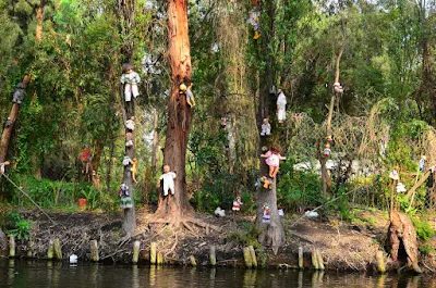
Broken and deteriorated dolls of various styles and colors are found throughout the island, originally placed by the former owner of the island, Julián Santana Barrera. Julián believed that dolls helped to chase away the spirit of a girl drowned years ago. Santana drowned as well in the same place in 2001.


he Island of the Dolls, originally owned by Don Julián Santana, is full of dolls hanging from trees and buildings covered with cobwebs and insects. The place was named during the 1950s when the owner began to hang them as protection against evil spirits. Santana was a neighbor of the Barrio de la Asunción, where he used to go to drink pulque after having sold his vegetables, until, due to superstitions, he began to preach the Bible, being expelled from the sector.

According to legend, a young woman drowned entangled among the lilies of the canal and her body was found on the banks of the Santampa chinampas. Don Julián began to experience inexplicable situations so, terrified, he placed dolls that he found in the garbage or in the canals of Cuemanco with the idea that they would scare the soul of the young woman. He also found a doll floating nearby and, assuming it belonged to the deceased girl, hung it from a tree as a sign of respect. After this, he began to hear whispers, footsteps, and anguished wails in the darkness even though his hut hidden deep inside the woods of Xochimilco was miles away from civilization. Driven by fear, he spent the next fifty years hanging more and more dolls, some missing body parts, all over the island in an attempt to appease what he believed to be the drowned girl's spirit.

In 1987, an Eco-tourist rescue was made and the island was found covered with water lily. Since then and after the death of Don Julián, the chinampa became a place of great tourist affluence. The place gained fame after 1943, when Mexican filmmaker Emilio Fernández filmed María Candelaria there, with Dolores del Río and Pedro Armendáriz as protagonists. A significant number of international and local channels have featured articles on the island, including The Huffington Post, Travel Channel and ABC News.

After Barrera’s death in 2001—his body reportedly found in the exact spot where he found the girl’s body fifty years before the area became a popular tourist attraction where visitors bring more dolls. The locals describe it as "charmed" not haunted—even though travelers claim the dolls whisper to them. Professional photographer Cindy Vasko visited the island in 2015 and described it as the "creepiest place [she has] ever visited". The excursion began through maze-like canals, surrounded by lush greenery and singing birds, but soon her boat was slowed down by a swarm of lily pads and the canal fell ominously silent. She told MailOnline: "At the end of the journey, the trajinera turned along a bend in the waterway and I was struck by a surreal vision of hundreds, maybe thousands, of dolls hanging from trees on the tiny island." The dolls are still on the island, which is accessible by boat. The island was featured on the Travel Channel show Ghost Adventures and the Amazon Prime show Lore. It was also featured in BuzzFeed Unsolved.

The island of the dolls is an hour and a half from Embarcadero Cuemanco. The only access is via trajinera. Most rowers are willing to transport people to the island, but there are those who refuse due to superstitions. The journey, approximately one hour, includes a tour of the Ecological Area, the Ajolote Museum, the Apatlaco Canal, the Teshuilo Lagoon and the Llorona Island.

In addition to hundreds of dolls, the island also contains a small museum with some articles from local newspapers about the island and the previous owner. There are a store and three rooms, one of which seems to have been used as a bedroom. In this room is the first doll that Julian collected, as well as Agustinita, his favorite doll.

Some of the visitors place offerings around this doll in exchange for miracles and blessings, some others change their clothes and maintain it as a form of worship.

Aug 4, 2019

Darvaza gas crater (The Door to Hell), Turkmenistan

The Darvaza gas crater known locally as the Door to Hell or Gates of Hell, is a natural gas field collapsed into an underground cavern located in Derweze, Turkmenistan. Geologists intentionally set it on fire to prevent the spread of methane gas, and it is thought to have been burning continuously since 1971. The gas crater has a total area of 5,350 m2. Its diameter is 69 m (226 ft), and its depth is 30 m (98 ft).

The Turkmen government hopes that the crater will become a popular tourist attraction. The surrounding area is also popular for wild desert camping.

The gas crater is located near the village of Derweze, also known as Darvaza. It is in the middle of the Karakum Desert, about 260 kilometers (160 mi) north of Ashgabat, the capital of Turkmenistan. The gas reserve found here is one of the largest in the world. The name "Door to Hell" was given to the field by the locals, referring to the fire, boiling mud, and orange flames in the large crater, which has a diameter of 70 meters (230 ft). The hot spots range over an area with a width of 60 meters (200 ft) and to a depth of about 20 meters (66 ft).


According to Turkmen geologist Anatoly Bushmakin, the site was identified by Soviet engineers in 1971. It was originally thought to be a substantial oil field site. The engineers set up a drilling rig and operations to assess the quantity of oil available at the site. Soon after the preliminary survey found a natural gas pocket, the ground beneath the drilling rig and camp collapsed into a wide crater and was buried.

Expecting dangerous releases of poisonous gases from the cavern into nearby towns, the engineers considered it advisable to burn the gas off. It was estimated that the gas would burn out within a few weeks, but it has instead continued to burn for more than four decades.

The early years of the crater's history are uncertain: local geologists say the collapse into a crater happened in the 1960s, and the gases were not set on fire until the 1980s. There are, however, no records available of either the Soviet or Turkmen version of events.

In April 2010, the President of Turkmenistan, Gurbanguly Berdimuhamedow, visited the site and ordered that the hole should be closed. In 2013, he declared the part of the Karakum Desert with the crater a nature reserve.

The crater was featured in an episode of the National Geographic Channel series Die Trying. In the July 16, 2014 episode "Crater of Fire", explorer George Kourounis became the first person to set foot at the bottom, gathering samples of extremophile microorganisms. An edited photograph of the crater was also released as publicity for the then-upcoming 2014 Godzilla film, with the image depicting MONARCH agents and vehicles investigating the site.