Feb 4, 2019

Salar de Uyuni (World's Largest Mirror), Andes in Southwest Bolivia

Salar de Uyuni or Salar de Tunupa is the world's largest salt flat, at 10,582 square kilometers (4,086 sq mi). It is in the Daniel Campos Province in Potosí in southwest Bolivia, near the crest of the Andes and is at an elevation of 3,656 meters (11,995 ft) above sea level.

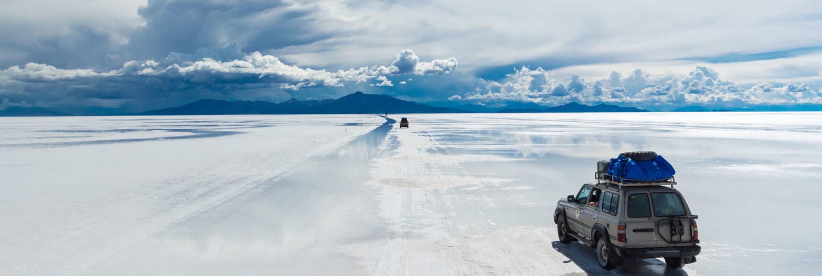
The Salar was formed as a result of transformations between several prehistoric lakes. It is covered by a few meters of salt crust, which has an extraordinary flatness with the average elevation variations within one meter over the entire area of the Salar. The crust serves as a source of salt and covers a pool of brine, which is exceptionally rich in lithium. It contains 50% to 70% of the world's known lithium reserves. The large area, clear skies, and exceptional flatness of the surface make the Salar an ideal object for calibrating the altimeters of Earth observation satellites. Following rain, a thin layer of dead calm water transforms the flat into the world's largest mirror, 129 kilometers (80 miles) across. 

The Salar serves as the major transport route across the Bolivian Altiplano and is a major breeding ground for several species of flamingos. Salar de Uyuni is also a climatologist transitional zone since the towering tropical cumulus congest us and cumulonimbus incus clouds that form in the eastern part of the salt flat during the summer cannot permeate beyond its drier western edges, near the Chilean border and the Atacama Desert.
 
Salar is salt flat in Spanish. Uyuni originates from the Aymara language and means a pen (enclosure); Uyuni is a surname and the name of a town that serves as a gateway for tourists visiting the Salar. Thus Salar de Uyuni can be loosely translated as a salt flat with enclosures, the latter possibly referring to the "islands" of the Salar; or as "salt-flat at Uyuni


Salar de Uyuni is part of the Altiplano of Bolivia in South America. The Altiplano is a high plateau, which was formed during uplift of the Andes mountains. The plateau includes fresh and saltwater lakes as well as salt flats and is surrounded by mountains with no drainage outlets. The Salar contains a large amount of sodium, potassium, lithium and magnesium as well as borax. Of those, lithium is arguably most important as it is a vital component of many electric batteries. With estimated 9,000,000. The Bolivia holds about 43 % of the world's known lithium reserves; most of those are in the Salar de Uyuni

The area has a relatively stable average temperature with a peak at 21 °C in November to January and a low of 13 °C in June. The nights are cold all through the year, with temperatures between −9 °C and 5 °C. The relative humidity is rather low and constant throughout the year at 30% to 45%. The rainfall is also low at 1 mm to 3 mm per month between April and November, but it may increase up to 80 mm in January. However, except for January, even in the rainy season the number of rainy days is fewer than 5 per month and Every November, Salar de Uyuni is the breeding ground for three species of pink South American flamingo: the Chilean, Andean, and rare James's flamingos, their color presumably originating from feeding on pink algae. About 80 other bird species are present, including the horned coot, Andean goose, and Andean hillstar. The Andean fox, or culpeo, is also present, and islands in the Salar host colonies of rabbit-like viscachas

Salar de Uyuni attracts tourists from around the world. As it is far from the cities, a number of hotels have been built in the area. Due to lack of conventional construction materials, many of them are almost entirely (walls, roof, furniture) built with salt blocks cut from the Salar. The first such hotel, named Palacio de Sal, was erected in 1993–1995 in the middle of the salt flat, and soon became a popular tourist destination. However, its location in the center of a desert caused sanitation problems, as most waste had to be collected manually. Mismanagement caused serious environmental pollution and the hotel had to be dismantled in 2002. One major tourist attraction is an antique train cemetery. It is 3 km outside Uyuni and is connected to it by the old train tracks. The town served in the past as a distribution hub for the trains carrying minerals en route to Pacific Ocean ports. The rail lines were built by British engineers arriving near the end of the 19th century and formed a sizeable community in Uyuni. The engineers were invited by the British-sponsored Antofagasta and Bolivia Railway Companies, now Ferrocarril de Antofagasta a Bolivia. The rail construction started in 1888 and ended in 1892. It was encouraged by Bolivian President Aniceto Arce, who believed Bolivia would flourish with a good transport system, but it was also constantly sabotaged by the local Aymara indigenous Indians who saw it as an intrusion into their lives. The trains were mostly used by the mining companies. In the 1940s, the mining industry collapsed, partly because of mineral depletion. Many trains were abandoned, producing the train cemetery. There are proposals to build a museum from the cemetery.

Feb 3, 2019

The Marble Caves of Chile (Unique Places of the World), Chile Chico, Chile

The Marble Caves of Chile are sometimes called “the Marble Caverns,” “the Marble Cathedral,” or “the Marble Chapel.” Care should be used when using these other names because they may refer to other specific features within the marble caves. In the native tongue, the caves are known as “Cuevas de Mármol.”  

Aggressive waves have washed up against the marble (calcium carbonate) for years, and slowly shaped the curved walls. However, these strong walls of marble cave in Patagonia did not instantly mold into the unique structure you see today. This process has been occurring for over six centuries! Its smooth and vibrant walls are now a reflection of the lake’s azure waters, which often change in color depending on the water levels and time of year.

The caves are situated in the Patagonian Andes. More specifically, the Marble Caves are sitting on a peninsula of marble that borders Lake General Carrera (as it is called in Chile). The lake is shared by Chile and Argentina and is known as Lake Buenos Aires on the Argentinian side.


The uniqueness of the caves ranges from its formation to the spectacular beauty that it is today. The beauty that is found there has taken over 6,000 years. Furthermore, the caves glow a range of magical colors depending on the level of the water. The stones themselves do not glow. Instead, the water reflects a range of cerulean hues and intensities that create a magical and tantalizing effect. During spring, the shallow levels of water reflect a turquoise hue on the caves. The high levels of water during the summer brought about by glacial melting provide a deep cerulean blue hue. At times, the reflections may also be white, grey, or the occasional pink. While they may seem ordinary on the outside, they are anything but. The biggest threat to the caves is the water. The erosion that has shaped the caves may very well be its undoing in the future. The reason for this is because the erosion caused by the wave action is unchecked. The beautiful smooth pillars that make the caves stable may be completely eroded thus collapsing the beautiful feature. This argument becomes even more convincing while observing the feature from the outside. The topmost part looks bigger and heavier than the supporting bottom.

The area around the lake is a typical aquatic one full of fish (such as trout and salmon), plants, and other forms of aquatic life. The land around the lake is also lush with vegetation in the surrounding range. Generally, the weather around these parts of Chile and Argentina is humid and cold. However, the regions around the lake have their own micro climate of a sunny and warm nature.

The caves are a popular destination for tourists from all around the world. Nature lovers and photographers often frequent the site. The most popular period for tourism is usually between December and February. The caves are inaccessible by road and can only be reached by boat. Tourists board a boat from a nearby remote town known as Puerto Rio Tranquillo.

Jan 1, 2019

Son Doong Cave (Cave Passage in the World), Phong Nha Ke Bang National Park, Quang Binh, Central Vietnam

Son Doong Cave (Vietnamese: Hang Son Doong) is world's largest cave, located in Quang Binh province, Vietnam. It is found by a local man named Ho Khanh in 1991 and was recently discovered in 2009 by British cavers, led by Howard Limbert. The name "Son Doong" cave means "mountain river cave", It was created 2-5 million years ago by river water eroding away the limestone underneath the mountain Where the limestone was weak, the ceiling collapsed creating huge skylights.
 
Son Doong Cave is known as the world’s largest natural cave, housing many limestone grottoes, stalactites and stalagmites. Set within Phong Nha-Ke Bang National Park (about 500km south of Hanoi), the cave is a must visit for adventurous travelers looking to explore one of Vietnam’s natural gems during their holiday.


Hang Sơn Đoòng was found by a local man named Hồ Khanh in 1991. The whistling sound of wind and roar of a rushing stream in the cave heard through the entrance as well as the steep descent prevented the local people from entering the cave. Only in 2009 did the cave become internationally known after a group of cavers from the British Cave Research Association, led by Howard Limbert, conducted a survey in Phong Nha-Kẻ Bàng from 10 to 14 April 2009. Their progress was stopped by a large, 60-metre (200 ft) high flowstone-coated wall, which was named the Great Wall of Vietnam. It was traversed in 2010 when the group reached the end of the cave passage

Formed of Carboniferous/Permian limestone, the main Sơn Đoòng cave passage is the largest known cave passage in the world by volume – 38.4×10⁶ cubic meters (1.36×10⁹ cu ft), according to Howard Limbert. It is more than 5 kilometers (3.1 mi) long, 200 meters (660 ft) high and 150 meters (490 ft) wide. Its cross-section is believed to be twice that of the next largest passage, in Deer Cave, Malaysia. The cave runs for approximately 9 kilometers (5.6 mi) and is punctuated by 2 large dolines, which are areas where the ceiling of the cave has collapsed. The dolines allow sunlight to enter sections of the cave, resulting in the growth of trees as well as other vegetation. The cave contains some of the tallest known stalagmites in the world, which are up to 70 m tall. Behind the Great Wall of Vietnam were found cave pearls the size of baseballs, an abnormally large size

To reach Hang Son Doong, it’s a six-km-long hike through the rainforest, which includes passing through a small village that’s home to the Ban Doong ethnic group. Entrance to Phong Nha-Ke Bang National Park costs VND 40,000, plus additional fees (which usually range between VND 80,000 and VND 150,000) to enter the caves via a guided tour. Oxalis Adventure Tours offer a four-day, three-night Son Doong Cave Expedition that’s available between February and August. Priced at VND 68,700,000 per person, the tour is inclusive of camping equipment, safety gear and caving equipment, as well as four meals a day, bottled water, a first aid kit and medical rescue equipment. The expedition also benefits from guidance from a professional technical advisor, an English-speaking guide, five safety assistants, and a porter team to carry gear and prepare meals throughout the journey.

Read more at: http://www.vietnam-guide.com/attractions/son-doong-cave.htm?cid=ch:OTH:001
 
Read more at: http://www.vietnam-guide.com/attractions/son-doong-cave.htm?cid=ch:OTH:001

Dec 31, 2018

Crooked Forest (The mysterious), Northwest Poland

Crooked Forest  is the group of 400 pine trees in the northwest of Poland appear to be almost normal, but they are not. If you look at the base of these trees, you might feel like you’ve just entered a strange mystical fairy tale. All of the trees have the same northward 90-degree bend at the base of their limb. Known as the “Crooked Forest,” this unique site remains an unexplained mystery. Every tree in the Crooked Forest has the same haunting bend, but despite bent beginnings, all of the trees have grown to be tall and seemingly unhampered by their C shape curves. Some experts believe that the trees grew like this because they incurred some sort of damage to the tip and along some side branches.Trees are resilient, and so they continued to thrive, relying on the one branch they had left to take over complete function and grow upwards. Whatever damage occurred to one tree must have happened to them all because they remain uniform in deformity.


 The Crooked Forest is around 80 years old. It is estimated that the damage that made them look how they do today occurred when the trees were about 7 years old. This would have been before the Second World War reached Poland. Which helps to explain the most popular theory about how the trees came to be crooked. As the story goes, in 1930 a group of farmers planted these trees, intentionally damaging the base in order to create some sort of product, perhaps uniquely shaped furniture. The world may never know if it’s true because the farmers were unable to finish their work after the invasion on Poland during World War II dismantled their plans.It is likely the trees were formed like this to make furniture, ship mantels, or numerous other woodworking projects. After all it’s not unheard of to grow trees with a curve in the branch for certain wood-made parts. This practice produces what is known as “compass timbers.”

Even if that’s the reason these trees are now crooked, it still seems so odd and unexplained, simply because someone’s work was never completed. Others surmise that a snowstorm could have knocked the trees like this, freezing them into a bent position until the snow and ice melted come spring. The possibilities are truly endless when it comes to this unsolved mystery. There are plenty of trees in the area, all of which grow upright from the base without the funky curve distinct to the Crooked Forest clan. The Crooked Forest is an odd occurrence in a seemingly ordinary place. So perhaps you are wondering why none of the locals have answers to what caused the formation of the Crooked Forest.

This is likely because the local town was devastated during World War II. It wasn’t until the 1970’s, when a new power and heat plant came to the town that it began to reestablish itself. The Crooked Forest is located right near this power plant, known as Dolna Odra (‘Lower Oder’) power plant. Today tourists come to enjoy many beautiful natural sites common to this area—none of which happen to be as unexplainable as the Crooked Forest. If you are ever in Poland you can visit the 22 rows of oddly shaped trees. The Crooked Forest is located in a suburb called Gryfino in the Zachodniopomorskie province. One look at the forest and you start to imagine endless possibilities, so much history packed into the roots of these trees-if only trees could talk!

Mount Roraima (Hike to the top of the “Lost World”), South America

Mount Roraima is the highest of the Pakaraima chain of tepui plateaus in South America. First described by the English explorer Sir Walter Raleigh during his 1595 expedition, its 31-square-kilometre (12-square-mile) summit area is bounded on all sides by cliffs rising 400 metres (1,300 ft). The mountain also serves as the tripoint of Venezuela, Guyana and Brazil. Mount Roraima lies on the Guiana Shield in the southeastern corner of Venezuela's 30,000-square-kilometre (12,000-square-mile) Canaima National Park forming the highest peak of Guyana's Highland Range.

The highest point in Guyana and the highest point of the Brazilian state of Roraima lie on the plateau, but Venezuela and Brazil have higher mountains elsewhere. The triple border point is at 5°12′08″N 60°44′07″W, but the mountain's highest point is Laberintos del Norte. 
 
Many of the species found on Roraima are unique to the tepui plateaus with two local endemic plants found on Roraima summit. Plants such as pitcher plants, Campanula , and the rare Rapatea heather are commonly found on the escarpment and summit. It rains almost every day of the year. Almost the entire surface of the summit is bare sandstone, with only a few bushes and algae present. Low scanty and bristling vegetation is also found in the small, sandy marshes that intersperse the rocky summit. Most of the nutrients that are present in the soil are washed away by torrents that cascade over the edge, forming some of the highest waterfalls in the world.

There are multiple examples of unique fauna atop Mount Roraima. Oreophrynella quelchii, commonly called the Roraima Bush Toad, is a diurnal toad usually found on open rock surfaces and shrubland. It is a species of toad in the family Bufonidae and breeds by direct development. The species is currently listed as vulnerable and there is a need for increased education among tourists to make them aware of the importance of not handling these animals in the wild. Close population monitoring is also required, particularly since this species is known only from a single location. The species is protected in Monumento Natural Los Tepuyes in Venezuela, and Parque Nacional Monte Roraima in Brazil


Although the steep sides of the plateau make it difficult to access, it was the first recorded major tepui to be climbed: Sir Everard im Thurn walked up a forested ramp in December 1884 to scale the plateau. This is the same route hikers take today. A report by the noted South American researcher Robert Schomburgk inspired the Scottish author Arthur Conan Doyle to write his novel The Lost World about the discovery of a living prehistoric world full of dinosaurs and other primordial creatures.

The only non-technical route to the top is the Paraitepui route from Venezuela; any other approach will involve climbing gear. Mount Roraima has been climbed on a few occasions from the Guyana and Brazil sides, but as the mountain is entirely bordered on both these sides by enormous sheer cliffs that include high overhanging (negative-inclination) stretches, these are extremely difficult and technical rock climbing routes. Such climbs would also require difficult authorizations for entering restricted-access national parks in the respective countries.In Brazil the Monte Roraima National Park lies within the Raposa Serra do Sol Indigenous Territory, and is not open to the public without permission.

The 2013 Austrian documentary Jäger des Augenblicks - Ein Abenteuer am Mount Roraima (Moment Hunters - An Adventure on Mount Roraima) shows rock climbers Kurt Albert, Holger Heuber, and Stefan Glowacz climbing to the top of Mount Roraima from the Guyana side. Similarly, in 2010 Brazilian climbers Eliseu Frechou, Fernando Leal and Márcio Bruno opened a new route on the Guyanese side, climbing to the top in 12 days of a very difficult vertical wall climb.

Jul 22, 2018

Rainbow River or Caño Cristales (Color of Nature), Serrania de la Macarena, Colombia

Rainbov River or Caño Cristales is a Colombian river located in the Serrania de la Macarena province of Meta. It's a tributary of the Guayabero River. The river is commonly called the "River of Five Colors" or the "Liquid Rainbow," and is even referred to as the most beautiful river in the world due to its striking colors. The bed of the river from the end of July through November is variously colored yellow, green, blue, black, and especially red, the last caused by Macarenia clavigera plants (family Podostemaceae) on the bottom of the river.


The quartzite rocks of the Serrania de la Macarena tableland formed approximately 1.2 billion years ago. They are a western extension of the Guiana Shield of Venezuela.

Caño Cristales is a fast river with many rapids and waterfalls. Often in the bed have formed small circular pits - giant's kettles, which have been formed by pebbles or chunks of harder rocks. Once one of these harder rock fragments falls into one of the cavities, it is rotated by the water current and begins to carve at the cavity wall and increases the dimensions of the pit

The Serranía de la Macarena is located on the border of three large ecosystems, each of them with high diversity of flora and fauna: the Andes, the Eastern Llanos, and the Amazon rain-forest. Plant and animal life are struggling with the lack of nutrients on the solid rock surface of the tableland and have developed diverse adaptations. The representative biome of the Serranía de La Macarena is the hydrophytic rainforest: hot, warm, and cold. The tableland is home to about 420 species of birds, 10 species of amphibians, 43 species of reptiles, and 69 primates.

Caño Cristales river has a wide variety of aquatic plants. The water of the river is extremely clear due to the lack of nutrients and small particles. Almost unique is the bright red - pink coloration of riverbed after the rainy period in the end of July - November. This color is caused by great quantities of endemic plant species Macarenia clavígera. This plant is found in some more local rivers, such as the Caño Siete Machos. These red plants adhere tightly to rocks in places where the river has faster current.