Sep 16, 2017

Moon Hill (Natural Arch), Yangshuo Xian, Guilin Shi, Guangxi, China

Moon Hill is a hill with a natural arch through it a few kilometers outside Yangshuo in southern China's Guangxi autonomous region. It is so named for a wide, semicircular hole through the hill, all that remains of what was once a limestone cave formed in the phreatic zone. Like most formations in the region, it is karst. It is also a popular tourist attraction.

It takes roughly 20 minutes to climb (about 800 steps) to the arch, or considerably longer for those who mean to reach the hill's summit. Access is not free and visitors must pay an entrance fee to be allowed to climb the hill. Souvenirs and refreshment vendors often follow climbers up and down the path.

In addition to a concrete tourist path which passes through the arch, and a somewhat rougher, steeper path leading to the summit above the arch, Moon Hill has several rock climbing routes, the first of which was climbed by Todd Skinner in the 1990s. It has also been used for abseils in several adventure races. Moon Hill offers some broad, panoramic views of the surrounding countryside, which is characterized by the knobby karst hills found throughout the region.


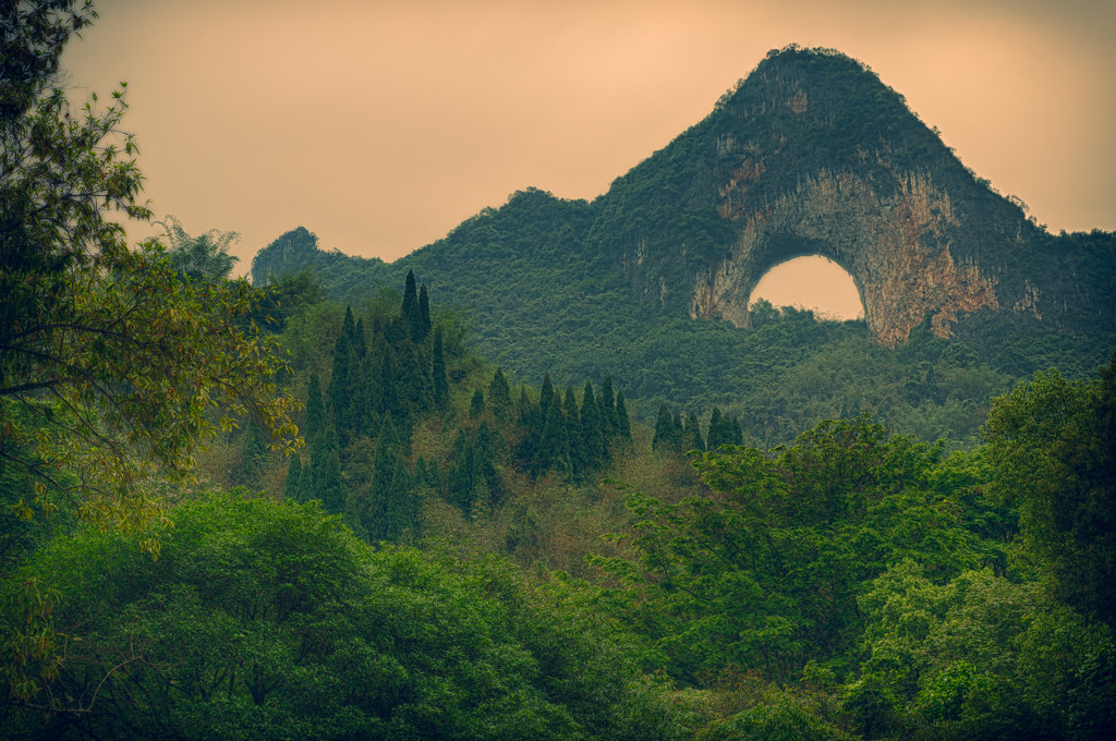
Moon Hill is a huge piece of rock with a moon-shaped hole in its center. The 800 marble stairs called "Appreciating Moon Path" can lead you to the top of the hill and to get a close view of the Moon Cave. Like most karts caves, there are lots of peculiar shaped stalactites hanging on the ceiling of the Moon Cave. Some are like Buddha’s warrior attendants, some like the goddess of the moon and some like jade rabbits. When cycling passed Moon Hill, with the change of viewpoints, the Moon Cave will take on the different looks of a "full moon", "half moon" or "crescent moon".

Moon Hill is also an great place for rock climbing. With 14 rock climbing routes on the north-west side, Moon Hill offers plenty of challenges for both amateur and professional climbers. 
The moon-shaped hole measures 50 m wide and 50 m tall, under the arch of which are stalactites of various shapes.The original tourist route is called, "To Moon Hill the local way". This ride is nice but it is now crowded with locals selling postcards, back rubbers, tacky souvenirs or you may get a local dressed up to look like a farmer. They are just posing to try to get you to take a photo for which they will want money. Some locals put coloured ribbons on water buffalo horns to also try to get you to take photos for money. We recommend that you do the bike ride late in the afternoon as many have gone home and you can avoid the hawkers. 

 Another route that will take you to moon hill is the "new local way". This ride is a bit longer but there are no people tring to selling you anything on the way. This ride will give you a glimpse of the rural lifestyle. You can also take in the old village of  Long tang or have lunch at the Mountain Retreat which is situated on the Yulong river and has stunning views.

Sep 15, 2017

Longsheng Rice Terrace (Dragon's Backbone), Longsheng County, Guangxi, China.

The Longsheng Rice Terrace, also called the Longji Rice Terraces are located in Longsheng County, about 100 kilometers (62 mi) from Guilin, Guangxi, China.

The terraced fields are built along the slope winding from the riverside up to the mountain top, between 600 to 800 meters (2,000 to 2,600 ft) above sea level. A coiling terrace line that starts from the mountain foot up to the mountain top divides the mountain into layers of water in spring, layers of green rice shoots in summer, layers of rice in fall, and layers of frost in winter. The terraced fields were mostly built about 650 years ago.

Longji (Dragon's Backbone) Terraced Rice Fields received their name because the rice terraces resemble a dragon's scales, while the summit of the mountain range looks like the backbone of the dragon. In early June, water is pumped over the rice paddies and young plants are transferred to the main terraces.


The Dragon's Backbone Rice Terraces is a beautiful natural picture. The linked together rice terraces vary from season to season. In spring, the water is irrigated into the fields and the terraces look like great chains or ribbons hung on the hillsides. When the onset of summer, green waves rush continuously down the mountainside from the heaven. The theme of autumn is the harvest, with the mountainside decorated with the gold of ripened millet. Coming into winter, the whole mountain will be covered with white snow, just like dragons playing with water.
As well as its amazing scenery, Longji is also the area to visit to experience China’s ethnic minorities' culture. The Zhuang and the Yao nationalities live here, though mainly it is the Zhuang people. The women dress in unique and colorful costumes, singing and dancing. Guests also can join in with them to enjoy the original Zhuang life and culture, and even stay with local families enjoying both the Longji tea and the Longji wine.
For More Details - Official Website

Sep 14, 2017

Liechtensteinklamm, Salzburg, Austria

Liechtensteinklamm (Liechtenstein Gorge) is a particularly narrow gorge with walls up to 300m high, located in the Austrian Alps 50 km south of Salzburg. It is around 4 km long and named after Johann II of Liechtenstein who had the walkways installed in 1875.

The gorge is around 4 km in length of which 1 km is accessible to visitors by means of wooden walkways (closed in winter months). It has a depth of up to 300m and in some places is only a few meters wide. At the end of the gorge is a waterfall. It receives around 100,000 visitors a year.

The waters of the Großarler Ache, a mountain stream, formed the gorge over thousands of years. In 1875 work began by members of the Pongau Alpine Club to make the gorge accessible, however was unfinished due to a lack of funds. Prince Johann II. of Liechtenstein, who ran a hunting lodge in the nearby Großarl, donated 600 guilders for an expansion of the work. At the completion of work in 1876 the gorge was renamed to honour the generous donation from the Prince. According to legend, the gorge was created when the devil full of anger and rage over a failed plan, flew across the canyon throwing water into it with such force as to carve the rock.


One of the deepest and longest ravines in the Alps, the Liechtensteinklamm is off the beaten track but well worth the detour. The jaw-dropping chasm was carved out during the last Ice Age; it's named after Johann II, Prince of Liechtenstein, who poured plenty of money into making the gorge accessible in the 19th century. Following raging waters flanked by vertical 300m-high cliffs, the footpath crosses bridges and passes through tunnels gouged into slate cliffs veined with white granite.
The mossy boulders and crags glisten with spray from the water, which is at its most striking in the late afternoon when the sunlight turns it opal blue. The trail culminates at a spectacular 50m waterfall. Allow at least an hour to walk the gorge. Trains run frequently between Werfen and St Johann im Pongau, a 4km walk from the gorge

Sep 13, 2017

Chamarel Seven Coloured Earth, Rivière Noire District, Mauritius

The Seven Coloured Earths are a geological formation and prominent tourist attraction found in the Chamarel plain of the Rivière Noire District in south-western Mauritius. It is a relatively small area of sand dunes comprising sand of seven distinct colours (approximately red, brown, violet, green, blue, purple and yellow). The main feature of the place is that since these differently coloured sands spontaneously settle in different layers, dunes acquire a surrealistic, striped colouring. Another interesting feature of Chamarel's Coloured Earths is that the dunes seemingly never erode, in spite of Mauritius' torrential tropical rains.

The “seven-coloured earth” of Chamarel is a geological curiosity and a major tourist attraction of Mauritius. This is a small (7500 m2) area of strikingly bare landscape located within a large, dense forest. The earth is particularly unusual; created by volcanic rocks that cooled at different temperatures, the earth form beautiful patterns of colour in the exposed hillsides. The rocks were pulverized into sands with various shades of red, brown, grey, and purple. Since the earth was first exposed, rains had carved beautiful patterns of many colours into the hillside. When visiting the park, you will be able to walk between the many sand dunes, along trails and see this unique sight. Also, there is a small petting farm where you can see and pet Giant Turtles which found their home at the park.


Since the earth was first exposed, rains had carved beautiful patterns into the hillside, creating an effect of earthen meringue. At first you'll notice shadows on the hills, creating the illusion of different colours, but soon you realise that the colours are real and the shadows were the illusion.

Sunrise is the best time to see the Coloured Earths. Geologists are still intrigued by the rolling dunes of multi-coloured lunar-like landscape. The colours, red, brown, violet, green, blue, purple and yellow never erode in spite of torrential downpours and adverse climatic conditions.

The Colored Earth of Chamarel has become one of Mauritius' main tourist attractions since the 1960s. Nowadays, the dunes are protected by a wooden fence and visitors are not allowed to climb on them, although they can look at the scenery from observation outposts placed along the fence. Curio shops in the area sell small test-tubes filled up with the coloured earths.