Aug 11, 2019

The Cordillera Paine, Torres Del Paine National Park, Chile

The Cordillera Paine is a mountain group in Torres del Paine National Park in Chilean Patagonia. It is located 280 km (170 mi) north of Punta Arenas, and about 1,960 km south of the Chilean capital Santiago. It belongs to the Commune of Torres del Painein Última Esperanza Province of Magallanes and Antártica Chilena Region. No accurate surveys have been published, and published elevations have been claimed to be seriously inflated, so most of the elevations given on this page are approximate. Paine means "blue" in the native Tehuelche  language and is pronounced PIE-nay.


The highest summit of the range is Cerro Paine Grande. For a long time its elevation was claimed to be 3,050 m or 3,251 m, but in August 2011 it was ascended for the third time, measured using GPS and found to be 2,884 m.

The three Towers of Paine form the centerpiece of Parque National Torres del Paine. The South Tower of Paine is about 2,500 m in elevation, is now thought to be the highest of the three, although this has not been definitely established. It was first climbed by Armando Aste. The Central Tower was first climbed in 1963 by Chris Bonington and Don Whillans. In 2017, three Belgian climbers, Nico Favresse, Siebe Vanhee and Sean Villanueva O'Driscoll, made the first free ascent up the rock face. The North Tower (about 2,260 m in elevation) was first climbed by Guido Monzino.

Other summits include the Cuerno Principal, about 2,100 m in elevation, and Cerro Paine Chico, which is usually quoted at about 2,650 m.

The range is made up of a yellowish granite underlain by grey gabbro-diorite laccolith and the sedimentary rocks it intrudes, deeply eroded by glaciers. The steep, light colored faces are eroded from the tougher, vertically jointed granitic rocks, while the foothills and dark cap rocks are the sedimentary country rock, in this case flysch deposited in the Cretaceous and later folded.

The Torres del Paine National Park an area of 2,400 km was declared a Biosphere Reserve by the UNESCO in 1978 and receives about 250,000 visitors annually. Trails and some campsites are maintained by Chile's National Forest Corporation, and mountain huts provide shelter and basic services.

The Island of the Dolls, Mexico

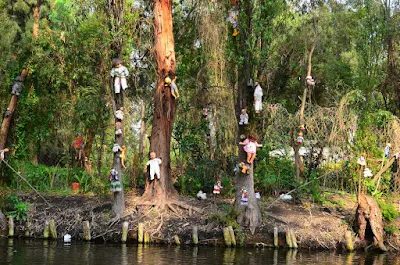
The Island of the Dolls, located in the channels of Xochimilco, south of the center of Mexico City, very close to the Estadio Azteca football stadium, is a chinampa of the Laguna de Teshuilo and one of the main attractions of the channels.

Broken and deteriorated dolls of various styles and colors are found throughout the island, originally placed by the former owner of the island, Julián Santana Barrera. Julián believed that dolls helped to chase away the spirit of a girl drowned years ago. Santana drowned as well in the same place in 2001.


he Island of the Dolls, originally owned by Don Julián Santana, is full of dolls hanging from trees and buildings covered with cobwebs and insects. The place was named during the 1950s when the owner began to hang them as protection against evil spirits. Santana was a neighbor of the Barrio de la Asunción, where he used to go to drink pulque after having sold his vegetables, until, due to superstitions, he began to preach the Bible, being expelled from the sector.

According to legend, a young woman drowned entangled among the lilies of the canal and her body was found on the banks of the Santampa chinampas. Don Julián began to experience inexplicable situations so, terrified, he placed dolls that he found in the garbage or in the canals of Cuemanco with the idea that they would scare the soul of the young woman. He also found a doll floating nearby and, assuming it belonged to the deceased girl, hung it from a tree as a sign of respect. After this, he began to hear whispers, footsteps, and anguished wails in the darkness even though his hut hidden deep inside the woods of Xochimilco was miles away from civilization. Driven by fear, he spent the next fifty years hanging more and more dolls, some missing body parts, all over the island in an attempt to appease what he believed to be the drowned girl's spirit.

In 1987, an Eco-tourist rescue was made and the island was found covered with water lily. Since then and after the death of Don Julián, the chinampa became a place of great tourist affluence. The place gained fame after 1943, when Mexican filmmaker Emilio Fernández filmed María Candelaria there, with Dolores del Río and Pedro Armendáriz as protagonists. A significant number of international and local channels have featured articles on the island, including The Huffington Post, Travel Channel and ABC News.

After Barrera’s death in 2001—his body reportedly found in the exact spot where he found the girl’s body fifty years before the area became a popular tourist attraction where visitors bring more dolls. The locals describe it as "charmed" not haunted—even though travelers claim the dolls whisper to them. Professional photographer Cindy Vasko visited the island in 2015 and described it as the "creepiest place [she has] ever visited". The excursion began through maze-like canals, surrounded by lush greenery and singing birds, but soon her boat was slowed down by a swarm of lily pads and the canal fell ominously silent. She told MailOnline: "At the end of the journey, the trajinera turned along a bend in the waterway and I was struck by a surreal vision of hundreds, maybe thousands, of dolls hanging from trees on the tiny island." The dolls are still on the island, which is accessible by boat. The island was featured on the Travel Channel show Ghost Adventures and the Amazon Prime show Lore. It was also featured in BuzzFeed Unsolved.

The island of the dolls is an hour and a half from Embarcadero Cuemanco. The only access is via trajinera. Most rowers are willing to transport people to the island, but there are those who refuse due to superstitions. The journey, approximately one hour, includes a tour of the Ecological Area, the Ajolote Museum, the Apatlaco Canal, the Teshuilo Lagoon and the Llorona Island.

In addition to hundreds of dolls, the island also contains a small museum with some articles from local newspapers about the island and the previous owner. There are a store and three rooms, one of which seems to have been used as a bedroom. In this room is the first doll that Julian collected, as well as Agustinita, his favorite doll.

Some of the visitors place offerings around this doll in exchange for miracles and blessings, some others change their clothes and maintain it as a form of worship.

Aug 4, 2019

Darvaza gas crater (The Door to Hell), Turkmenistan

The Darvaza gas crater known locally as the Door to Hell or Gates of Hell, is a natural gas field collapsed into an underground cavern located in Derweze, Turkmenistan. Geologists intentionally set it on fire to prevent the spread of methane gas, and it is thought to have been burning continuously since 1971. The gas crater has a total area of 5,350 m2. Its diameter is 69 m (226 ft), and its depth is 30 m (98 ft).

The Turkmen government hopes that the crater will become a popular tourist attraction. The surrounding area is also popular for wild desert camping.

The gas crater is located near the village of Derweze, also known as Darvaza. It is in the middle of the Karakum Desert, about 260 kilometers (160 mi) north of Ashgabat, the capital of Turkmenistan. The gas reserve found here is one of the largest in the world. The name "Door to Hell" was given to the field by the locals, referring to the fire, boiling mud, and orange flames in the large crater, which has a diameter of 70 meters (230 ft). The hot spots range over an area with a width of 60 meters (200 ft) and to a depth of about 20 meters (66 ft).


According to Turkmen geologist Anatoly Bushmakin, the site was identified by Soviet engineers in 1971. It was originally thought to be a substantial oil field site. The engineers set up a drilling rig and operations to assess the quantity of oil available at the site. Soon after the preliminary survey found a natural gas pocket, the ground beneath the drilling rig and camp collapsed into a wide crater and was buried.

Expecting dangerous releases of poisonous gases from the cavern into nearby towns, the engineers considered it advisable to burn the gas off. It was estimated that the gas would burn out within a few weeks, but it has instead continued to burn for more than four decades.

The early years of the crater's history are uncertain: local geologists say the collapse into a crater happened in the 1960s, and the gases were not set on fire until the 1980s. There are, however, no records available of either the Soviet or Turkmen version of events.

In April 2010, the President of Turkmenistan, Gurbanguly Berdimuhamedow, visited the site and ordered that the hole should be closed. In 2013, he declared the part of the Karakum Desert with the crater a nature reserve.

The crater was featured in an episode of the National Geographic Channel series Die Trying. In the July 16, 2014 episode "Crater of Fire", explorer George Kourounis became the first person to set foot at the bottom, gathering samples of extremophile microorganisms. An edited photograph of the crater was also released as publicity for the then-upcoming 2014 Godzilla film, with the image depicting MONARCH agents and vehicles investigating the site.

Feb 6, 2019

Los Glaciares National Park, Santa Cruz Province, Argentina

Los Glaciares National Park covers an area of 726,927 ha (7,269.27 km2; 2,806.68 sq mi), making it the largest national park in the country. Established on 11 May 1937,it hosts a representative sample of Magellanic sub polar forest and west Patagonian steppe biodiversity in good state of conservation. In 1981, it was declared a World Heritage Site by UNESCO.

The park's name refers to the giant ice cap in the Andes, the largest outside of Antarctica, Greenland and Iceland, feeding 47 large glaciers, of which 13 flow towards the Atlantic Ocean. In other parts of the world, glaciers start at a height of at least 2,500 m (8,200 ft) above mean sea level, but due to the size of the ice cap, these glaciers begin at only 1,500 m (4,900 ft), sliding down to 200 m (660 ft). Los Glaciares borders Torres del Paine National Park to the south in Chilean territory. 

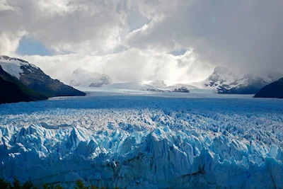
Los Glaciares owes its name to the numerous glaciers covering roughly half of the World Heritage property. Many of these glaciers are fed by the massive South Patagonian Ice Field, the most extensive South American relict of the glaciological processes of the Quaternary Period. In addition, there are impressive glaciers independent of the main ice field. The property therefore constitutes a massive freshwater reservoir. The Upsala, Onelli and Perito Moreno Glaciers calve into the icy and milky waters of the huge Lake Argentino, which is partly included in the property. The most striking sight is the famous Perito Moreno Glacier. This large glacier blocks a narrow channel formed by Lake Argentino thereby raising the water level temporarily. This in turn causes regular thunderous ruptures of the glacier tongue into the lake.


The mountains hold most of the humidity from the Pacific Ocean, letting through only the ice coldness (annual average of 7.5 °C (45.5 °F)) and creating the arid Patagonian steppe on the Argentine side of the range. This area is habitat for ñandúes, guanaco, cougar, and South American gray fox, the latter of which has suffered from the invasion of the cattle industry and are endangered. The guanaco, while not endangered, has had a dramatic decline in historic population due to large scale grazing of livestock throughout much of Patagonia. There are over 100 species of birds in the area (condors, eagles, and others). Between the ice and the Patagonian steppe there is a fertile area of Magellanic subpolar forests composed mainly of lengas and guindos. Within these more hospitable areas also live huemul deer and torrent duck.

Los Glaciares is a major attraction for international tourists. Starting points of tours are the village of El Calafate at the shore of Lake Argentino but outside the park, where the park's administration has its headquarters, and El Chaltén village in the northern part of the park, at the foot of the Fitz Roy. Other touristic points in the park include Lago del Desierto and Lago Roca.

For more Information - Los Glaciares National Park

Feb 4, 2019

Salar de Uyuni (World's Largest Mirror), Andes in Southwest Bolivia

Salar de Uyuni or Salar de Tunupa is the world's largest salt flat, at 10,582 square kilometers (4,086 sq mi). It is in the Daniel Campos Province in Potosí in southwest Bolivia, near the crest of the Andes and is at an elevation of 3,656 meters (11,995 ft) above sea level.

The Salar was formed as a result of transformations between several prehistoric lakes. It is covered by a few meters of salt crust, which has an extraordinary flatness with the average elevation variations within one meter over the entire area of the Salar. The crust serves as a source of salt and covers a pool of brine, which is exceptionally rich in lithium. It contains 50% to 70% of the world's known lithium reserves. The large area, clear skies, and exceptional flatness of the surface make the Salar an ideal object for calibrating the altimeters of Earth observation satellites. Following rain, a thin layer of dead calm water transforms the flat into the world's largest mirror, 129 kilometers (80 miles) across. 

The Salar serves as the major transport route across the Bolivian Altiplano and is a major breeding ground for several species of flamingos. Salar de Uyuni is also a climatologist transitional zone since the towering tropical cumulus congest us and cumulonimbus incus clouds that form in the eastern part of the salt flat during the summer cannot permeate beyond its drier western edges, near the Chilean border and the Atacama Desert.
 
Salar is salt flat in Spanish. Uyuni originates from the Aymara language and means a pen (enclosure); Uyuni is a surname and the name of a town that serves as a gateway for tourists visiting the Salar. Thus Salar de Uyuni can be loosely translated as a salt flat with enclosures, the latter possibly referring to the "islands" of the Salar; or as "salt-flat at Uyuni


Salar de Uyuni is part of the Altiplano of Bolivia in South America. The Altiplano is a high plateau, which was formed during uplift of the Andes mountains. The plateau includes fresh and saltwater lakes as well as salt flats and is surrounded by mountains with no drainage outlets. The Salar contains a large amount of sodium, potassium, lithium and magnesium as well as borax. Of those, lithium is arguably most important as it is a vital component of many electric batteries. With estimated 9,000,000. The Bolivia holds about 43 % of the world's known lithium reserves; most of those are in the Salar de Uyuni

The area has a relatively stable average temperature with a peak at 21 °C in November to January and a low of 13 °C in June. The nights are cold all through the year, with temperatures between −9 °C and 5 °C. The relative humidity is rather low and constant throughout the year at 30% to 45%. The rainfall is also low at 1 mm to 3 mm per month between April and November, but it may increase up to 80 mm in January. However, except for January, even in the rainy season the number of rainy days is fewer than 5 per month and Every November, Salar de Uyuni is the breeding ground for three species of pink South American flamingo: the Chilean, Andean, and rare James's flamingos, their color presumably originating from feeding on pink algae. About 80 other bird species are present, including the horned coot, Andean goose, and Andean hillstar. The Andean fox, or culpeo, is also present, and islands in the Salar host colonies of rabbit-like viscachas

Salar de Uyuni attracts tourists from around the world. As it is far from the cities, a number of hotels have been built in the area. Due to lack of conventional construction materials, many of them are almost entirely (walls, roof, furniture) built with salt blocks cut from the Salar. The first such hotel, named Palacio de Sal, was erected in 1993–1995 in the middle of the salt flat, and soon became a popular tourist destination. However, its location in the center of a desert caused sanitation problems, as most waste had to be collected manually. Mismanagement caused serious environmental pollution and the hotel had to be dismantled in 2002. One major tourist attraction is an antique train cemetery. It is 3 km outside Uyuni and is connected to it by the old train tracks. The town served in the past as a distribution hub for the trains carrying minerals en route to Pacific Ocean ports. The rail lines were built by British engineers arriving near the end of the 19th century and formed a sizeable community in Uyuni. The engineers were invited by the British-sponsored Antofagasta and Bolivia Railway Companies, now Ferrocarril de Antofagasta a Bolivia. The rail construction started in 1888 and ended in 1892. It was encouraged by Bolivian President Aniceto Arce, who believed Bolivia would flourish with a good transport system, but it was also constantly sabotaged by the local Aymara indigenous Indians who saw it as an intrusion into their lives. The trains were mostly used by the mining companies. In the 1940s, the mining industry collapsed, partly because of mineral depletion. Many trains were abandoned, producing the train cemetery. There are proposals to build a museum from the cemetery.