Oct 5, 2013

The Bermuda Triangle (Devil's Triangle), Western Part Of The North Atlantic Ocean

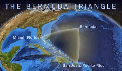
The Bermuda Triangle, also known as the Devil's Triangle, is a loosely-defined region in the western part of the North Atlantic Ocean, where a number of aircraft and ships are said to have disappeared under mysterious circumstances. Most reputable sources dismiss the idea that there is any mystery. The vicinity of the Bermuda Triangle is one of the most heavily traveled shipping lanes in the world, with ships frequently crossing through it for ports in the Americas, Europe, and the Caribbean islands. Cruise ships and pleasure craft regularly sail through the region, and commercial and private aircraft routinely fly over it.

Popular culture has attributed various disappearances to the paranormal or activity by extraterrestrial beings. Documented evidence indicates that a significant percentage of the incidents were spurious, inaccurately reported, or embellished by later authors.


In 1964, Vincent Gaddis wrote in the pulp magazine Argosy of the boundaries of the Bermuda Triangle, giving its vertices as Miami, San Juan, Puerto Rico, and Bermuda. Subsequent writers did not necessarily follow this definition. Some writers gave different boundaries and vertices to the triangle, with the total area varying from 1,300,000 to 3,900,000 km2 (500,000 to 1,510,000 sq mi).Consequently, the determination of which accidents occurred inside the triangle depends on which writer reported them. The United States Board on Geographic Names does not recognize the Bermuda Triangle.

The earliest suggestion of unusual disappearances in the Bermuda area appeared in a September 17, 1950, article published in The Miami Herald (Associated Press) by Edward Van Winkle Jones.Two years later, Fate magazine published "Sea Mystery at Our Back Door", a short article by George X. Sand covering the loss of several planes and ships, including the loss of Flight 19, a group of five US Navy Grumman TBM Avenger torpedo bombers on a training mission. Sand's article was the first to lay out the now-familiar triangular area where the losses took place. Flight 19 alone would be covered again in the April 1962 issue of American Legion magazine. In it, author Allan W. Eckert wrote that the flight leader had been heard saying, "We are entering white water, nothing seems right. We don't know where we are, the water is green, no white." He also wrote that officials at the Navy board of inquiry stated that the planes "flew off to Mars." Sand's article was the first to suggest a supernatural element to the Flight 19 incident. In the February 1964 issue of Argosy, Vincent Gaddis' article "The Deadly Bermuda Triangle" argued that Flight 19 and other disappearances were part of a pattern of strange events in the region. The next year, Gaddis expanded this article into a book, Invisible Horizons.

Lawrence David Kusche, author of The Bermuda Triangle Mystery: Solved (1975) argued that many claims of Gaddis and subsequent writers were often exaggerated, dubious or unverifiable. Kusche's research revealed a number of inaccuracies and inconsistencies between Berlitz's accounts and statements from eyewitnesses, participants, and others involved in the initial incidents. Kusche noted cases where pertinent information went unreported, such as the disappearance of round-the-world yachtsman Donald Crowhurst, which Berlitz had presented as a mystery, despite clear evidence to the contrary. Another example was the ore-carrier recounted by Berlitz as lost without trace three days out of an Atlanticport when it had been lost three days out of a port with the same name in the Pacific Ocean. Kusche also argued that a large percentage of the incidents that sparked allegations of the Triangle's mysterious influence actually occurred well outside it. Often his research was simple: he would review period newspapers of the dates of reported incidents and find reports on possibly relevant events like unusual weather, that were never mentioned in the disappearance stories.

Kusche concluded that:

  • The number of ships and aircraft reported missing in the area was not significantly greater, proportionally speaking, than in any other part of the ocean.
  • In an area frequented by tropical cyclones, the number of disappearances that did occur were, for the most part, neither disproportionate, unlikely, nor mysterious.
  • Furthermore, Berlitz and other writers would often fail to mention such storms or even represent the disappearance as having happened in calm conditions when meteorological records clearly contradict this.
  • The numbers themselves had been exaggerated by sloppy research. A boat's disappearance, for example, would be reported, but its eventual return to port may not have been.
  • Some disappearances had, in fact, never happened. One plane crash was said to have taken place in 1937, off Daytona Beach, Florida, in front of hundreds of witnesses; a check of the local papers revealed nothing.
  • The legend of the Bermuda Triangle is a manufactured mystery, perpetuated by writers who either purposely or unknowingly made use of misconceptions, faulty reasoning, and sensationalism.
For More Details - Bermuda Triangle

Uluru (Colour Changing Mountain), Kata Tjuta National Park, Australia

Uluru, also known as Ayers Rock and officially gazetted as "Uluru / Ayers Rock", is a large sandstone rock formation in the southern part of the Northern Territory in central Australia. It lies 335 km (208 mi) south west of the nearest large town, Alice Springs, 450 km (280 mi) by road.

Uluru is sacred to the Pitjantjatjara Anangu, the Aboriginal people of the area. The area around the formation is home to an abundance of springs, waterholes, rock caves and ancient paintings. Uluru is listed as a UNESCO World Heritage Site. Uluru and Kata Tjuta, also known as the Olgas, are the two major features of the Uluṟu-Kata Tjuṯa National Park.
On 19 July 1873, the surveyorWilliam Gosse sighted the landmark and named it Ayers Rock in honour of the then Chief Secretary of South Australia, Sir Henry Ayers. Since then, both names have been used. In 1993, a dual naming policy was adopted that allowed official names that consist of both the traditional Aboriginal name and the English name. On 15 December 1993, it was renamed "Ayers Rock / Uluru" and became the first official dual-named feature in the Northern Territory. The order of the dual names was officially reversed to "Uluru / Ayers Rock" on 6 November 2002 following a request from the Regional Tourism Association in Alice Springs


Uluru is one of Australia's most recognizable natural landmarks. The sandstone formation stands 348 m (1,142 ft) high, rising 863 m (2,831 ft) above sea level with most of its bulk lying underground, and has a total circumference of 9.4 km (5.8 mi). Both Uluru and the nearby Kata Tjuta formation have great cultural significance for the Aṉangu people, the traditional inhabitants of the area, who lead walking tours to inform visitors about the local flora and fauna, bush food and the Aboriginal dream time stories of the area.

Uluru is notable for appearing to change colour at different times of the day and year, most notably when it glows red at dawn and sunset. Kata Tjuta, also called Mount Olga or the Olgas, lies 25 km (16 mi) west of Uluru. Special viewing areas with road access and parking have been constructed to give tourists the best views of both sites at dawn and dusk.
Uluru is an inselberg, literally "island mountain". An inselberg is a prominent isolated residual knob or hill that rises abruptly from and is surrounded by extensive and relatively flat erosion lowlands in a hot, dry region. Uluru is also often referred to as a monolith, although this is a somewhat ambiguous term that is generally avoided by geologists. The remarkable feature of Uluru is its homogeneity and lack of jointing and parting at bedding surfaces, leading to the lack of development of scree slopes and soil. These characteristics led to its survival, while the surrounding rocks were eroded. For the purpose of mapping and describing the geological history of the area, geologists refer to the rock strata making up Uluru as the Mutitjulu Arkose, and it is one of many sedimentary formations filling the Amadeus Basin.

The development of tourism infrastructure adjacent to the base of Uluru that began in the 1950s soon produced adverse environmental impacts. It was decided in the early 1970s to remove all accommodation-related tourist facilities and re-establish them outside the park. In 1975, a reservation of 104 square kilometers0 (40 sq mi) of land beyond the park's northern boundary, 15 kilometers (9 mi) from Uluru, was approved for the development of a tourist facility and an associated airport, to be known as Yulara. The camp ground within the park was closed in 1983 and the motels closed in late 1984, coinciding with the opening of the Yulara resort. In 1992, the majority interest in the Yulara resort held by the Northern Territory Government was sold and the resort was renamed Ayers Rock Resort.

Since the park was listed as a World Heritage Site, annual visitor numbers rose to over 400,000 visitors by the year 2000. Increased tourism provides regional and national economic benefits. It also presents an ongoing challenge to balance conservation of cultural values and visitor needs. 
For More Details -  Uluru

Jul 5, 2013

Hao Xianzhang, A Chinese Farmer that Grows Buddha Shaped Pears, China

Hao Xianzhang in China has been growing pears that are shaped like 'Buddha.' He has managed to create what some would call the holiest fruits ever, pears shaped like Buddha.

Hao has been working on his pear-growing technique for six years and this season he managed to grow 10,000 Buddha-shaped baby pears. Each fruit is grown in an intricate Buddha mould and ends up looking like a juicy figurine. The ingenious farmer says the locals in his home village of Hexia, norther China, have been buying his Buddha pears as soon as he picks them from the trees. Most of them think they are cute and that they bring good luck.

Hao Xianzhang pears aren’t cheap, roughly $1.8 each, but their success in China convinced him to start exporting them into Europe.


Hao Xianzhang is the Chinese farmer who has developed this idea of growing Buddha shaped pears that look like babies, hoping that this unusual idea will boost his business. Hao got this idea to shape pears when he saw jelly molded into various shapes at a supermarket.

Hao Xianzhang owns an orchard in northern Hebei province of China, and is growing these holy buddha shaped pears by attaching baby-buddha shaped fiberglass and plastic moulds to the young pears for about six months. As mentioned in the message, the farmer spent nearly six years this way, perfecting the shape of baby pears, crafting and growing each one carefully inside an individual mould. 

It is interesting to note that in the year 2009, Hao sold almost all the 18,000 pears that he has cultivated for a hefty price of 50 Yuan ($7) a piece. Hao also received orders for about 70,000- 80,000 pieces of this buddha shaped fruit for the year 2010. Despite a hefty cost of £5 each at present, the locals in Hebia have been buying these holy Buddha shaped pears, considering it as a good luck fortune. Lately, the farmer is also planning to export this novel idea to the UK.

Karni Mata (The Rat Temple), Deshnoke, Bikaner, India

Karni Mata Temple was a female Hindu sage born in the Charan caste and is worshiped as the incarnation of the goddess Durga by her followers. She is an official deity of the royal family of Jodhpur and Bikaner. She lived an ascetic life and was widely revered during her own lifetime. At the request of the Maharaja of Bikaner, she laid the foundation stone two important forts in the region. The most famous of her temples is the temple of Deshnoke, which was created following her mysterious disappearance from her home. The temple is famous for its rats, which are treated as sacred and given protection in the temple. Contrary to some reports, the temple is of the Hindu sect and is not affiliated with the Jainism. Another temple dedicated to her during her lifetime differs from others in that it does not contain an image or idol of her but rather contains a foot-print to symbolize her visit to that place.


The Karni Mata Temple at Deshnoke, 30 km from Bikaner, India, was completed in the early 20th century in the late Mughal style by Maharaja Ganga Singh of Bikaner. The temple was further enhanced by Kundanlal Verma of Hyderabad-based Karni Jewelers in 1999. The silver gates to the temple and the marble carvings were also donated by him. During Navratri thousands of people travel to the temple by foot.

Legend has it that Laxman, Karni Mata's stepson (or the son of one of her storytellers), drowned in a pond in Kapil Sarovar in Kolayat Tehsiil while he was attempting to drink from. Karni Mata implored Yama, the god of death, to revive him. First refusing, Yama eventually relented, permitting Laxman and all of Karni mata's male children to be reincarnated as rats.

The temple is famous for the approximately 20,000 Black Rats that live, and are revered in, the temple.If one of the rats is killed, it must be replaced with one made of solid gold. Eating food that has been nibbled on by the rats is considered to be a "high honor". Out of all of the thousands of rats in the temple, there are a few white rats, which are considered to be especially holy. They are believed to be the manifestations of Karni Mata herself and her four sons. Sighting them is a special blessing and visitors put in extensive efforts to bring them forth, offering prasad, a sweet holy food.

For more Infomation- Karni Mata Temple

Jul 3, 2013

The Christmas Island Red Crab ( Largest Migration of Crab), Christmas Island, Australian Territory in the Indian Ocean

The Christmas Island red crab (Gecarcoidea natalis), is a species of land crab that is endemic to Christmas Island and the Cocos (Keeling) Islands in the Indian Ocean. Although restricted to a relatively small area, it has been estimated that 43.7 million adult red crabs lived on Christmas Island alone, but the accidental introduction of the yellow crazy ant is believed to have killed about 10–15 million of these in recent years. Christmas Island red crabs eat mostly fallen leaves and flowers, but will occasionally eat other animals, including other red crabs (see cannibalism) if the opportunity arises.


Christmas Island red crabs are rather large crabs with the carapace measuring up to 116 millimetres (4.6 in) wide. The claws are usually of equal size, unless one becomes injured or detached, in which case the limb will regenerate. The male crabs are generally larger than the females, while adult females have a much broader abdomen (only apparent above 3 years of age) and usually have smaller claws.  Bright red is their most common color, but some can be orange or the much rarer purple.

Like most land crabs, red crabs use gills to breathe and must take great care to conserve body moisture. Although red crabs are diurnal, they usually avoid direct sunlight so as not to dry out. Despite lower temperatures and higher humidity, red crabs are almost completely inactive at night. Red crabs also dig burrows to shelter themselves from the sun and will usually stay in the same burrow through the year. During the dry season, they will cover the entrance to their burrows with a loose wad of leaves to maintain high humidity in their burrow and will virtually disappear for 3 months until the start of the wet season. Apart from their breeding season, Red crabs are solitary animals and will defend their burrow from intruders

For most of the year, red crabs can be found within Christmas Islands' forests, however, each year they must migrate to the coast to breed. The beginning of the wet season (usually October/November) allows the crabs to increase their activity and stimulates their annual migration. The timing of their migration is also linked to the phases of the moon. During this migration red crabs abandon their burrows and travel to the coast to mate and spawn. This normally requires at least a week, with the male crabs usually arriving before the females. Once on the shore, the male crabs excavate burrows, which they must defend from other males. Mating occurs in or near the burrows. Soon after mating the males return to the forest while the females remain in the burrow for another two weeks to lay their eggs. At the end of the incubation period the females leave their burrows and release their eggs into the ocean. This occurs precisely at the turn of the high tide during the last quarter of the moon. The females then return to the forest while the crab larvae spend another 3–4 weeks at sea before returning to land as juvenile crabs

Surveys have found a density 0.09–0.57 adult red crabs per square meter, equaling an estimated total population of 43.7 million on Christmas Island. Others have estimated that about 120 million are found on this island, but the basis for that claim is unclear.

During their annual breeding migration, red crabs will often have to cross roads, sometimes as many as 3 or 4, to get to their breeding grounds and then back to forest. As a result, red crabs are frequently crushed by vehicles and sometimes cause accidents due to their tough exoskeletons which are capable of puncturing tires. To ensure both the safety of crabs and humans, local park rangers work hard to ensure that the crabs can safely cross the island to the coast. Park rangers set up aluminum barriers called "crab fences" along heavily traveled roads. The crab fences funnel the crabs towards small underpasses called "crab grids" so that the crabs can safely cross under the roads. In recent years, the human inhabitants of Christmas Island have become more tolerant and respectful of the crabs during their annual migration and are now more cautious while driving, which helps to minimize crab casualties. Further, "a five meter high bridge has also been constructed at one point along the road to help the crabs move across the island and continue their migration.

Jun 27, 2013

Ski Dubai Snow Park (The Worlds Largest Snow Park), Ski Dubai

Ski Dubai Snow Park is the worlds largest Snow Park is nowhere else but at Ski Dubai. Located within the Middle East’s first indoor ski resort, Ski Dubai, Snow Park is a breathtaking 3,000 square meter,real snow wonderland.

Fun for the whole family, the world's largest indoor snow park houses an amazing 3,000 square meters of snow. Strap on your snow boots and experience Twin Track Bobsled runs, a Snow Cavern filled with interactive experiences, and Tobogganing hills. Head one down to the upgrade station for an exhilarating ride on the Giant Ball or jump on the chairlift for a one of a kind bird's eye view of the entire park.


The most popular of all the winter sports, Skiing provides enjoyment and excitement for all ages. Have an unforgettable experience while gliding through fresh snow all year round and Ski Dubai!...Whether taking your first steps on the beginner slope to the moment when you learn the necessary skill to tackle the more advanced runs, Skiing will keep you wanting to learn more.

Ski Dubai has 5 runs that vary in difficulty, height and gradient, the longest run being 400 meters with a fall of over 60 meters. Test your skills on the world's first indoor black run or practice your turns on the gentle beginner slopes. Skiers and snowboarders of all skill levels will enjoy these various slopes and snowboarders can also practice their stunts in the Freestyle Zone. Kids and parents alike will have fun in the huge interactive Snow Park, which at 3000 square meters is the largest indoor snow park in the world.

You don't have to worry about ski clothing or equipment either. Ski Dubai has thought of it all and offers guests the use of winter clothing, ski and snowboard equipment. Your skis will carry you down the slope, and our quad-chairlift and tow lift will promptly carry you back to the top for another run.

You will enjoy our themed restaurants; St Moritz Cafe at the entrance to Ski Dubai, and Avalanche Cafe at mid-station, with views of the slope. Our exclusive retail shop, Snow Pro, has expert staff to advise you on your equipment needs and our team of professional Ski School instructors will guide you through the simple, fun process of learning to ski or snowboard. 
  • 22,500m2 covered with real snow all year round (equivalent to 3 football fields)
  • Temperature maintained at a comfortable -1 o to - 2o
  • 85 meters high (approximately 25 stories) and 80 meters wide
  • 5 different runs of varying difficulty and length, longest run of 400 meters
  • Full capacity of 1500 guests
  • Freestyle zone
  • Corporate and group bookings
  • 3,000m2 Snow Park with a snow cavern