Jul 5, 2013

Hao Xianzhang, A Chinese Farmer that Grows Buddha Shaped Pears, China

Hao Xianzhang in China has been growing pears that are shaped like 'Buddha.' He has managed to create what some would call the holiest fruits ever, pears shaped like Buddha.

Hao has been working on his pear-growing technique for six years and this season he managed to grow 10,000 Buddha-shaped baby pears. Each fruit is grown in an intricate Buddha mould and ends up looking like a juicy figurine. The ingenious farmer says the locals in his home village of Hexia, norther China, have been buying his Buddha pears as soon as he picks them from the trees. Most of them think they are cute and that they bring good luck.

Hao Xianzhang pears aren’t cheap, roughly $1.8 each, but their success in China convinced him to start exporting them into Europe.


Hao Xianzhang is the Chinese farmer who has developed this idea of growing Buddha shaped pears that look like babies, hoping that this unusual idea will boost his business. Hao got this idea to shape pears when he saw jelly molded into various shapes at a supermarket.

Hao Xianzhang owns an orchard in northern Hebei province of China, and is growing these holy buddha shaped pears by attaching baby-buddha shaped fiberglass and plastic moulds to the young pears for about six months. As mentioned in the message, the farmer spent nearly six years this way, perfecting the shape of baby pears, crafting and growing each one carefully inside an individual mould. 

It is interesting to note that in the year 2009, Hao sold almost all the 18,000 pears that he has cultivated for a hefty price of 50 Yuan ($7) a piece. Hao also received orders for about 70,000- 80,000 pieces of this buddha shaped fruit for the year 2010. Despite a hefty cost of £5 each at present, the locals in Hebia have been buying these holy Buddha shaped pears, considering it as a good luck fortune. Lately, the farmer is also planning to export this novel idea to the UK.

Karni Mata (The Rat Temple), Deshnoke, Bikaner, India

Karni Mata Temple was a female Hindu sage born in the Charan caste and is worshiped as the incarnation of the goddess Durga by her followers. She is an official deity of the royal family of Jodhpur and Bikaner. She lived an ascetic life and was widely revered during her own lifetime. At the request of the Maharaja of Bikaner, she laid the foundation stone two important forts in the region. The most famous of her temples is the temple of Deshnoke, which was created following her mysterious disappearance from her home. The temple is famous for its rats, which are treated as sacred and given protection in the temple. Contrary to some reports, the temple is of the Hindu sect and is not affiliated with the Jainism. Another temple dedicated to her during her lifetime differs from others in that it does not contain an image or idol of her but rather contains a foot-print to symbolize her visit to that place.


The Karni Mata Temple at Deshnoke, 30 km from Bikaner, India, was completed in the early 20th century in the late Mughal style by Maharaja Ganga Singh of Bikaner. The temple was further enhanced by Kundanlal Verma of Hyderabad-based Karni Jewelers in 1999. The silver gates to the temple and the marble carvings were also donated by him. During Navratri thousands of people travel to the temple by foot.

Legend has it that Laxman, Karni Mata's stepson (or the son of one of her storytellers), drowned in a pond in Kapil Sarovar in Kolayat Tehsiil while he was attempting to drink from. Karni Mata implored Yama, the god of death, to revive him. First refusing, Yama eventually relented, permitting Laxman and all of Karni mata's male children to be reincarnated as rats.

The temple is famous for the approximately 20,000 Black Rats that live, and are revered in, the temple.If one of the rats is killed, it must be replaced with one made of solid gold. Eating food that has been nibbled on by the rats is considered to be a "high honor". Out of all of the thousands of rats in the temple, there are a few white rats, which are considered to be especially holy. They are believed to be the manifestations of Karni Mata herself and her four sons. Sighting them is a special blessing and visitors put in extensive efforts to bring them forth, offering prasad, a sweet holy food.

For more Infomation- Karni Mata Temple

Jul 3, 2013

The Christmas Island Red Crab ( Largest Migration of Crab), Christmas Island, Australian Territory in the Indian Ocean

The Christmas Island red crab (Gecarcoidea natalis), is a species of land crab that is endemic to Christmas Island and the Cocos (Keeling) Islands in the Indian Ocean. Although restricted to a relatively small area, it has been estimated that 43.7 million adult red crabs lived on Christmas Island alone, but the accidental introduction of the yellow crazy ant is believed to have killed about 10–15 million of these in recent years. Christmas Island red crabs eat mostly fallen leaves and flowers, but will occasionally eat other animals, including other red crabs (see cannibalism) if the opportunity arises.


Christmas Island red crabs are rather large crabs with the carapace measuring up to 116 millimetres (4.6 in) wide. The claws are usually of equal size, unless one becomes injured or detached, in which case the limb will regenerate. The male crabs are generally larger than the females, while adult females have a much broader abdomen (only apparent above 3 years of age) and usually have smaller claws.  Bright red is their most common color, but some can be orange or the much rarer purple.

Like most land crabs, red crabs use gills to breathe and must take great care to conserve body moisture. Although red crabs are diurnal, they usually avoid direct sunlight so as not to dry out. Despite lower temperatures and higher humidity, red crabs are almost completely inactive at night. Red crabs also dig burrows to shelter themselves from the sun and will usually stay in the same burrow through the year. During the dry season, they will cover the entrance to their burrows with a loose wad of leaves to maintain high humidity in their burrow and will virtually disappear for 3 months until the start of the wet season. Apart from their breeding season, Red crabs are solitary animals and will defend their burrow from intruders

For most of the year, red crabs can be found within Christmas Islands' forests, however, each year they must migrate to the coast to breed. The beginning of the wet season (usually October/November) allows the crabs to increase their activity and stimulates their annual migration. The timing of their migration is also linked to the phases of the moon. During this migration red crabs abandon their burrows and travel to the coast to mate and spawn. This normally requires at least a week, with the male crabs usually arriving before the females. Once on the shore, the male crabs excavate burrows, which they must defend from other males. Mating occurs in or near the burrows. Soon after mating the males return to the forest while the females remain in the burrow for another two weeks to lay their eggs. At the end of the incubation period the females leave their burrows and release their eggs into the ocean. This occurs precisely at the turn of the high tide during the last quarter of the moon. The females then return to the forest while the crab larvae spend another 3–4 weeks at sea before returning to land as juvenile crabs

Surveys have found a density 0.09–0.57 adult red crabs per square meter, equaling an estimated total population of 43.7 million on Christmas Island. Others have estimated that about 120 million are found on this island, but the basis for that claim is unclear.

During their annual breeding migration, red crabs will often have to cross roads, sometimes as many as 3 or 4, to get to their breeding grounds and then back to forest. As a result, red crabs are frequently crushed by vehicles and sometimes cause accidents due to their tough exoskeletons which are capable of puncturing tires. To ensure both the safety of crabs and humans, local park rangers work hard to ensure that the crabs can safely cross the island to the coast. Park rangers set up aluminum barriers called "crab fences" along heavily traveled roads. The crab fences funnel the crabs towards small underpasses called "crab grids" so that the crabs can safely cross under the roads. In recent years, the human inhabitants of Christmas Island have become more tolerant and respectful of the crabs during their annual migration and are now more cautious while driving, which helps to minimize crab casualties. Further, "a five meter high bridge has also been constructed at one point along the road to help the crabs move across the island and continue their migration.

Jun 27, 2013

Ski Dubai Snow Park (The Worlds Largest Snow Park), Ski Dubai

Ski Dubai Snow Park is the worlds largest Snow Park is nowhere else but at Ski Dubai. Located within the Middle East’s first indoor ski resort, Ski Dubai, Snow Park is a breathtaking 3,000 square meter,real snow wonderland.

Fun for the whole family, the world's largest indoor snow park houses an amazing 3,000 square meters of snow. Strap on your snow boots and experience Twin Track Bobsled runs, a Snow Cavern filled with interactive experiences, and Tobogganing hills. Head one down to the upgrade station for an exhilarating ride on the Giant Ball or jump on the chairlift for a one of a kind bird's eye view of the entire park.


The most popular of all the winter sports, Skiing provides enjoyment and excitement for all ages. Have an unforgettable experience while gliding through fresh snow all year round and Ski Dubai!...Whether taking your first steps on the beginner slope to the moment when you learn the necessary skill to tackle the more advanced runs, Skiing will keep you wanting to learn more.

Ski Dubai has 5 runs that vary in difficulty, height and gradient, the longest run being 400 meters with a fall of over 60 meters. Test your skills on the world's first indoor black run or practice your turns on the gentle beginner slopes. Skiers and snowboarders of all skill levels will enjoy these various slopes and snowboarders can also practice their stunts in the Freestyle Zone. Kids and parents alike will have fun in the huge interactive Snow Park, which at 3000 square meters is the largest indoor snow park in the world.

You don't have to worry about ski clothing or equipment either. Ski Dubai has thought of it all and offers guests the use of winter clothing, ski and snowboard equipment. Your skis will carry you down the slope, and our quad-chairlift and tow lift will promptly carry you back to the top for another run.

You will enjoy our themed restaurants; St Moritz Cafe at the entrance to Ski Dubai, and Avalanche Cafe at mid-station, with views of the slope. Our exclusive retail shop, Snow Pro, has expert staff to advise you on your equipment needs and our team of professional Ski School instructors will guide you through the simple, fun process of learning to ski or snowboard. 
  • 22,500m2 covered with real snow all year round (equivalent to 3 football fields)
  • Temperature maintained at a comfortable -1 o to - 2o
  • 85 meters high (approximately 25 stories) and 80 meters wide
  • 5 different runs of varying difficulty and length, longest run of 400 meters
  • Full capacity of 1500 guests
  • Freestyle zone
  • Corporate and group bookings
  • 3,000m2 Snow Park with a snow cavern

Apr 27, 2013

The World's Largest Bus

The world's largest bus that is 101ft long and can carry 256 passengers

    1) The Auto Tram Extra Grand is being trialed in Dresden, Germany
    2) It is the longest bus in the world at nearly 101ft long vehicle
    3) Beijing and Shanghai have placed orders for the bus
    4) It runs mostly on electric power
    5) The vehicle combines the capacity of a small train with the maneuverability of a bus


The big bendy bus premiered in the eastern city of Dresden this week where it will soon roll into service with the local transportation authority on trial runs as Beijing and Shanghai placed their orders for the vehicle which costs $1.25 million (almost £778,000) per bus. It combines the passenger capacity of a small train with the maneuverability of a bus and runs on a hybrid engine that kicks in when the electric batteries run down, charging them as it propels the vehicle.

Bus drivers will not require a special license to drive the long, bendy bus thanks to a unique computer steering system which keeps the length of the bus precisely in line with the front carriage. The system is less expensive to run and cheaper to put into operation than a rail commuter system, prompting other cities to inquire about the super-sized buses. Dr Klinger said: The Auto Tram has a considerable advantage compared to light rail systems. While it is the longest bus in the world, the bus with the largest capacity is China's New Liner Series which has 300 seats on a 82ft bus.

Apr 17, 2013

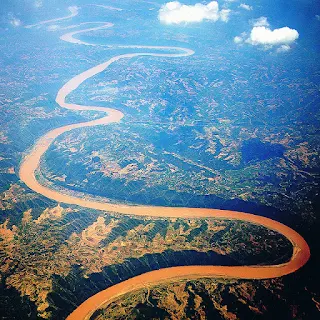
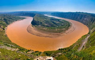
The Yellow River (The Cradle of Chinese Civilization), Bayan Har Mountains, Western China

The Yellow River or Huang He is the second-longest river in Asia, following the Yangtze River, and the sixth-longest river system in the world at the estimated length of 5,464 km (3,395 mi). Originating in the Bayan Har Mountains in Qinghai province of western China, it flows through nine provinces, and it empties into the Bohai Sea near the city of Dongying in Shandong province. The Yellow River basin has an east–west extent of about 1,900 kilometers (1,180 mi) and a north–south extent of about 1,100 km (680 mi). 
 
Its total basin area is about 742,443 square kilometers (286,659 sq mi). Its basin was the birthplace of ancient Chinese civilization, and it was the most prosperous region in early Chinese history. However, because of frequent devastating floods and course changes produced by the continual elevation of the river bed, sometimes above the level of its surrounding farm fields, it also has the names China's Sorrow and Scourge of the Sons of Han.


According to the China Exploration and Research Society, the source of the Yellow River is at 34° 29' 31.1" N, 96° 20' 24.6" E in the Bayan Har Mountains near the eastern edge of the Yushu Tibetan Autonomous Prefecture. The source tributuaries drain into Gyaring Lake and Ngoring Lake on the western edge of Golog Prefecture high in the Bayan Har Mountains of Qinghai. In the Zoige Basin along the boundary with Gansu, the Yellow River loops northwest and then northeast before turning south, creating the "Ordos Loop", and then flows generally eastward across the North China Plain to the Gulf of Bohai, draining a basin of 752,443 square kilometers (290,520 sq mi) which nourishes 140 million people with drinking water and irrigation.

The Yellow River passes through seven present-day provinces and two autonomous regions, namely (from west to east) Qinghai, Gansu, Ningxia, Inner Mongolia, Shaanxi, Shanxi, Henan, and Shandong. Major cities along the present course of the Yellow River include (from west to east) Lanzhou, Yinchuan, Wuhai, Baotou, Luoyang, Zhengzhou, Kaifeng, and Jinan. The current mouth of the Yellow River is located at Kenli County, Shandong. The river is commonly divided into three stages. These are roughly the northeast of the Tibetan Plateau, the Ordos Loop, and the North China Plain. However, different scholars have different opinions on how the three stages are divided.

The Yellow River is notable for the large amount of silt it carries—1.6 billion tons annually at the point where it descends from the Loess Plateau. If it is running to the sea with sufficient volume, 1.4 billion tons are carried to the sea annually.[citation needed] One estimate gives 34 kilograms of silt per cubic meter as opposed to 10 for the Colorado and 1 for the Nile.

Its average discharge is said to be 2,110 cubic meters per second (32,000 for the Yangtze), with a maximum of 25,000 and minimum of 245. However, since 1972, it often runs dry before it reaches the sea. The low volume is due to increased agricultural irrigation, increased by a factor of five since 1950. Water diverted from the river as of 1999 served 140 million people and irrigated 74,000 km² (48,572 mi²) of land. The Yellow River delta totals 8,000 square kilometers (3,090 mi²). However, with the decrease in silt reaching the sea, it has been reported to be shrinking slightly each year since 1996 through erosion.

The highest volume occurs during the rainy season from July to October, when 60% of the annual volume of the river flows. Maximum demand for irrigation is needed between March and June. In order to capture excess water for use when needed and for flood control and electricity generation, several dams have been built, but their expected life is limited due to the high silt load. A proposed South–North Water Transfer Project involves several schemes to divert water from the Yangtze River: one in the western headwaters of the rivers where they are closest to one another, another from the upper reaches of the Han River, and a third using the route of the old Grand Canal. Due to its heavy load of silt the Yellow River is a depositing stream – that is, it deposits part of its carried burden of soil in its bed in stretches where it is flowing slowly. These deposits elevate the riverbed which flows between natural levees in its lower reaches. Should a flood occur, the river may break out of the levees into the surrounding lower flood plain and take a new channel. Historically this has occurred about once every hundred years. In modern times, considerable effort has been made to strengthen levees and control floods 
For more details - Yellow_River