Feb 3, 2013

Lake Hillier (Natural Wonder), South Coast, Western Australia

Lake Hillier is a saline lake on the edge of Middle Island, the largest of the islands and islets that make up the Recherche Archipelago in the Goldfields-Esperance region, off the south coast of Western Australia. It is particularly notable for its pink colour. A long and thin shore divides the Southern Ocean from the lake.

Lake Hillier is about 600 metres (2,000 ft) in length by about 250 m (820 ft) in width. The lake is surrounded by a rim of sand and a dense woodland of paperbark and eucalyptus trees with a narrow strip of sand dunes covered by vegetation separating its northern edge from the northern coast of Middle Island. The most notable feature of the lake is its pink, vibrant colour. The vibrant colour is permanent, and does not alter when the water is taken in a container. The pink colour is considered to be due to the presence of the organism Dunaliella salina. The Extreme Microbiome Project, part of the Association of Biomolecular Resource Facilities (ABRF), Metagenomics Research Group (MGRG), has performed a metagenomic analysis on the lake to find Dunaliella as well as Salinibacter ruber, Dechloromonas aromatica, and a few species of the Archaea. Air is the best mode of transportation for viewing the lake. At one point in its history the lake was used to collect salt.


Lake Hillier was visited by the Matthew Flinders' expedition on 15 January 1802. Flinders' journal entries are considered to be the first written records of the lake. Flinders visited Middle Island again in May 1803; he intended "to stop a day or two in Goose-Island Bay, for the purposes of procuring geese for our sick people, seal oil for our lamps, and a few casks of salt from the lake on Middle Island". It is reported that Flinders subsequently named the lake after William Hillier, a crew member of Investigator who died of dysentery on 20 May 1803 prior to the expedition's departure from Middle Island. In 1889, Edward Andrews investigated the commercial possibilities of producing salt from Lake Hillier, and briefly moved onto the island with both of his sons. They left after working the salt deposits for about one year. The lake was subject to salt mining during the late 19th century. The salt mining enterprise is reported as failing for a number of reasons including "the toxicity of the salt collected for consumption".

The only living organisms in Lake Hillier are microorganisms including Dunaliella salina, red algae which cause the salt content in the lake to create a red dye which helps produce the colour, as well as red halophilic bacteria, bacterioruberin, present in the salt crusts. Despite the unusual hue, the lake exhibits no known adverse effects upon humans. From above, the lake appears a solid bubble gum pink, but from the shoreline it appears more of a clear pink hue. The shoreline is also covered in salt crust deposits. In 2016 scientists from the Extreme Microbiome Project conducted extensive microbiome and metagenomic DNA sequencing and detected Haloquadratum, Haloferax, Salinibacter, Halobacterium, Halogeometricum, and several other halophilic organisms. Culturing from the water revealed a low concentration of Psychroflexus as well.

Despite the high salt content levels, Lake Hillier is safe to swim in. However it is not advisable nor allowed without previous approval by the Western Australia Dept of Environment Conservation However, there are very few ways to reach Lake Hillier. Aeroplane scenic flights are the most common method, with six flights a day departing Esperance Airport, flying over Lake Hillier via the nearby Cape Le Grand National Park. Cruises are also an option for passengers wanting to visit the isolated lake, and surrounding forest area.  As recently as 2012, Lake Hillier has been located within the boundaries of the Recherche Archipelago Nature Reserve. Since 2002, the lake itself has been considered to be a wetland of "subregional significance"

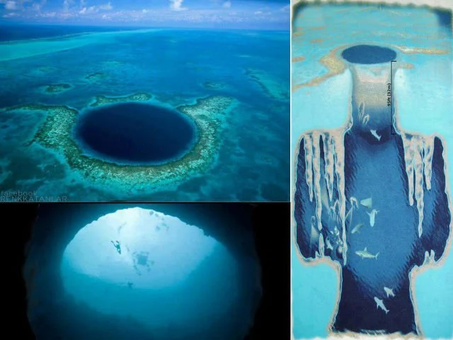
Great Blue Hole (Giant Marine Sinkhole), Coast of Belize

The Great Blue Hole is off the coast of Belize. It lies near the center of Lighthouse Reef, a small atoll 70 km (43 mi) from the mainland and Belize City. The hole is circular in shape, 318 m (1,043 ft) across and 124 m (407 ft) deep. It was formed during several episodes of Quaternary glaciation when sea levels were much lower. Analysis of stalactites found in the Great Blue Hole shows that formation took place 153,000; 66,000; 60,000; and 15,000 years ago. As the ocean began to rise again, the cave was flooded. The Great Blue Hole is a part of the larger Belize Barrier Reef Reserve System, a World Heritage Site of the United Nations Educational, Scientific and Cultural Organization (UNESCO).


Initial measured depth of Great Blue Hole was 125 m (410 ft) which is the most often cited depth up to this day. An expedition by the Cambrian Foundation in 1997 measured the hole's depth as 124 m (407 ft) at its deepest point. This difference in measurement can be explained by ongoing sedimentation or by imprecision in measurements. The purpose of this expedition was the collection of core samples from the floor of the Blue Hole and documentation of the cave system.To accomplish these tasks, all of the divers had to be certified in cave diving and mixed gases.

This site was made famous by Jacques Cousteau, who declared it one of the top five scuba diving sites in the world. In 1971 he brought his ship, the Calypso, to the hole to chart its depths.Investigations by this expedition confirmed the hole's origin as typical karts limestone formations, formed before rises in sea level in at least four stages, leaving ledges at depths of 21 m (69 ft), 49 m (161 ft), and 91 m (299 ft). Stalactites were retrieved from submerged caves, confirming their previous formation above sea level. Some of these stalactites were also off-vertical by 5˚ in a consistent orientation, indicating that there had also been some past geological shift and tilting of the underlying plateau, followed by a long period in the current plane. The tilt indicates that this was a movement of the land, rather than a rise in sea level alone.

Initial measured depth of Great Blue Hole was 125 m (410 ft) which is the most often cited depth up to this day. An expedition by the Cambrian Foundation in 1997 measured the hole's depth as 124 m (407 ft) at its deepest point. This difference in measurement can be explained by ongoing sedimentation or by imprecision in measurements. The expedition's goal was to collect core samples from the Blue Hole's floor and document the cave system. To accomplish these tasks, all of the divers had to be certified in cave diving and mixed gases.

The name "The Great Blue Hole" was coined by British diver and author Ned Middleton in the book "Ten Years Underwater".

This is a popular spot among recreational scuba divers who are lured by the opportunity to dive in sometimes crystal-clear water and meet several species of fish, including Midnight Parrotfish, Caribbean reef shark, and other juvenile fish species. Other species of sharks, such as the bull shark and hammerheads, have been reported there, but are not regularly sighted. Usually, day trips to the Great Blue Hole are full-day trips from the coastal tourist communities in Belize.

On-shore caves of similar formation, as large collapsed sinkholes, are well known in Belize and in the Yucatán Peninsula, where they are known as cenotes. Unlike the mainland cenotes which often link to underwater cave systems, there is little evidence of horizontal development in the Blue Hole.

In 2012 Discovery Channel ranked the Great Blue Hole as number one on its list of "The 10 Most Amazing Places on Earth".

Even though the Great Blue Hole is considered a bucket-list dive, one should be aware that it is not for divers of all skill levels – a prerequisite is logging more than 24 dives. It is also not a 'colorful dive', instead, divers witness a dark cave with impressive stalactites. The Great Blue Hole has also been the site of infrequent skydives. Both tandems and fun jumpers have landed in the ocean after rides from 12,000 feet.

Feb 2, 2013

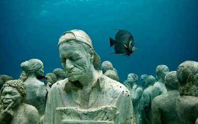
The Molinere Underwater Sculpture Park, Caribbean sea, West coast of Grenada, West Indies

The Molinere Underwater Sculpture Park is a collection of ecological underwater contemporary art located in the Caribbean sea off the west coast of Grenada, West Indies and was created by British sculptor Jason deCaires Taylor. In May 2006 the world's first underwater sculpture park was open for public viewing. Taylor′s aim was to engage local people with the underwater environment that surrounds them using his works which are derived from life casts of the local community. He installed concrete figures onto the ocean floor, mostly consisting of a range of human forms, from solitary individuals to a ring of children holding hands, facing into the oceanic currents.

Once positioned at the bottom of the ocean floor, Taylor’s concrete sculptures begin to mutate dramatically by taking amazing forms, because of the kaleidoscopic array of coral that attaches itself to them. As subsumed by the creeping algae and lichen, the concrete surfaces of the sculptures are not visible, and a lot of tropical fish and crustaceans take shelters within the cracks of the sculptures.

Taylor’s mesmerizing works of art help the spawning of new coral reefs, while, at the same time, freeing-up the surrounding ecosystem from the upshots of pollution, tourism and over fishing, ABC News reported.Scientists have predicted that the ocean’s natural coral landscape will die out by 2050 if measures are not taken to curb the current rate of destruction.

The Sculpture park, which began construction in 2006 is situated on the sandy ocean floor in the barren Molinere Bay and it now acts as an aid to relieve pressure on natural reefs which have become popular among water sports enthusiasts, particularly in nearby Flamingo Bay which is the most visited snorkeling destination on the island. There are over sixty-five concrete individual sculptures covering an area of over 800 square meters and in total weigh around 15 tonnes in dry cement. There has been some debate as to the intention of the park and whether it was a dedication to the slaves that were thrown overboard during the journey through the Middle Passage from West Africa to the Americas. In response the artist says “It was never my intention to have any connection to the Middle passage. Although it was not my intention from the outset I am very encouraged how it has resonated differently within various communities and feel it is working as an art piece by questioning our identity, history and stimulating debate.”- Jason de Caires Taylor.

The sculpture park is accessible via boat from the main port of St Georges (2 miles/3 km North of the capital) or Grand Anse Bay on the West coastline. The sculptures are situated in a variety of depths of water with a maximum of 12 meters, and the park is visited daily by scuba divers, snorkelers and glass bottom boats. Recently a local artist on the island has added new works to the sculpture park


Grace Reef was installed in 2006 at a depth of 12 feet. The first installation in the hurricane damaged bay of Molinere and consists of 16 concrete statues cast from the body of a local Grenadian woman and positioned lying down on the sea floor. After 14 months the figures had begun to distort with the in habitation of life.

The Lost Correspondent was installed in 2006 at a depth of 22 feet. Referenced to be a modern day Vesuvius disaster, he is a lone concrete figure at a desk poised over a typewriter. The surface of the desk is covered with a selection of newspaper articles dating back to the 1970s with many holding political significance from the Cuban alignment before the revolution.

The Unstill Life, installed in 2006 at a depth of 25 feet, is a classical study of an artist's still life using simple modern day objects like a table, vase and fruit bowl. The static sculpture overtime has its appearance constantly changed by the course of nature.

Vicissitudes, installed in 2007 at a depth of 14 feet, is Taylor's most recognized work in the park: a ring of 26 standing children, holding hands and facing outwards into the current. The design took six months to make, weighed 15 tonnes in dry cement and was constructed to withstand strong currents and tidal motion. The ring symbolizes the concept of life's ongoing cycle and highlights the importance of creating a sustainable and well managed environment for future generations, holding reference to the ability of children adapt to their surroundings.

The Fall From Grace, installed in 2007 at a depth of 21 feet, is a life size male figure riding a bicycle. After 8 months in the ocean, aquatic life was already making it a home. Tam CC Project was installed in 2007 at a depth of 6 feet. It is a construction of 18 concrete heads fixed to a rock face in shallow water. Casts were made of students faces from T. A. Marryshow Community College, Grenada.

Machu Picchu, Eastern Cordillera of Southern Peru

Machu Picchu located in the Eastern Cordillera of southern Peru, on a 2,430-metre (7,970 ft) mountain ridge. It is located in the Cusco Region, Urubamba Province, Machupicchu District, above the Sacred Valley, which is 80 kilometers (50 mi) northwest of Cuzco and through which the Urubamba River flows, cutting through the Cordillera and creating a canyon with a tropical mountain climate.

Most archaeologists believe that Machu Picchu was constructed as an estate for the Inca emperor Pachacuti (1438–1472). Often mistakenly referred to as the "Lost City of the Incas", it is the most familiar icon of Inca civilization. The Incas built the estate around 1450 but abandoned it a century later at the time of the Spanish conquest. Although known locally, it was not known to the Spanish during the colonial period and remained unknown to the outside world until American historian Hiram Bingham brought it to international attention in 1911.

Machu Picchu was built in the classical Inca style, with polished dry-stone walls. Its three primary structures are the Intihuatana, the Temple of the Sun, and the Room of the Three Windows. Most of the outlying buildings have been reconstructed in order to give tourists a better idea of how they originally appeared. By 1976, 30% of Machu Picchu had been restored and restoration continues.

Machu Picchu was declared a Peruvian Historic Sanctuary in 1981 and a UNESCOWorld Heritage Site in 1983. In 2007, Machu Picchu was voted one of the New Seven Wonders of the World in a worldwide Internet poll


Machu Picchu was built starting 1450–1460. Construction appears to date from two great Inca rulers, Pachacutec Inca Yupanqui (1438–1471) and Túpac Inca Yupanqui (1472–1493).There is a consensus among archaeologists that Pachacutec ordered the construction of the royal estate for himself, most likely after a successful military campaign. Though Machu Picchu is considered to be a "royal" estate, surprisingly, it would not have been passed down in the line of succession. Rather it was used for 80 years before being abandoned, seemingly because of the Spanish Conquests in other parts of the Inca Empire. It is possible that most of its inhabitants died from smallpox introduced by travelers before the Spanish conquistadors arrived in the area
 

Machu Picchu is both a cultural and natural UNESCO World Heritage Site. Since its discovery in 1911, growing numbers of tourists have visited the site each year, including 1,411,279 in 2017. As Peru's most visited tourist attraction and major revenue generator, it is continually exposed to economic and commercial forces. In the late 1990s, the Peruvian government granted concessions to allow the construction of a cable car and a luxury hotel, including a tourist complex with boutiques and restaurants and a bridge to the site. Many people protested the plans, including Peruvians and foreign scientists, saying that more visitors would pose a physical burden on the ruins. In 2018, plans were restarted to again construct a cable car to encourage Peruvians to visit Machu Picchu and boost domestic tourism. A no-fly zone exists above the area. UNESCO is considering putting Machu Picchu on its List of World Heritage in Danger.

During the 1980s a large rock from Machu Picchu's central plaza was moved to a different location to create a helicopter landing zone. In the 1990s, the government prohibited helicopter landings. In 2006, a Cusco-based company, Helicusco, sought approval for tourist flights over Machu Picchu. The resulting license was soon rescinded.

Tourist deaths have been linked to altitude sickness, floods and hiking accidents.UNESCO received criticism for allowing tourists at the location given high risks of landslides, earthquakes and injury due to decaying structures. In 2014 nude tourism was a trend at Machu Picchu and Peru's Ministry of Culture denounced the activity. Cusco's Regional Director of Culture increased surveillance to end the practice.

For details- Machu Picchu

Feb 1, 2013

Roopkund (A Mystery Skeleton Lake), Uttarakhand, India

Roopkund (locally known as Mystery and Skeletons Lake) is a high altitude glacial lake in the Uttarakhand state of India. It lies in the lap of Trishul massif and is famous for the hundreds of human skeletons found at the edge of the lake. The area is uninhabited, in the Himalayas at an altitude of 5,029 metres (16,499 feet). Surrounded by rock-strewn glaciers and snow-clad mountains, the lake is a popular trekking destination.

The Roopkund Lake in August 2014 A shallow lake, having a depth of about two meters, Roopkund has attracted attention because of the human skeletal remains that are visible at its bottom when the snow melts. Researchers have concluded that the skeletons are the remains of people killed in a sudden, violent hailstorm in the 9th century. Because of the human remains, the lake has been called Skeleton Lake in recent times.


Skeletons were rediscovered in 1942 by a Nanda Devi game reserve ranger H K Madhwal, although there are reports about these bones from the late-19th century. At first, British authorities feared that the skeletons represented casualties of a hidden Japanese invasion force, but it was found that the skeletons were far too old to be Japanese soldiers. The skeletons are visible in the clear water of the shallow lake during a one-month period when the ice melts. Along with the skeletons, wooden artifacts, iron spearheads, leather slippers, and rings were also found. When a team from National Geographic magazine retrieved about 30 skeletons, flesh was still attached to some of them. Geneticists, Niraj Rai along with Manvendra Singh at the Center for Cellular and Molecular Biology at Hyderabad, conducted DNA tests on a hundred samples from the lake and compared them to the current Indian population. Results indicated that 70 percent of them had an affinity with Iran, while the remaining belonged to the local population. It is hypothesized that the Iran group took the help of local porters to seek new land for settlement. Later studies placed the time of mass death around the 9th century CE (1,200 years old).

Local legend says that the King of Kanauj, Raja Jasdhaval, with his pregnant wife, Rani Balampa, their servants, a dance troupe and others went on a pilgrimage to Nanda Devi shrine, and the group faced a storm with large hailstones, from which the entire party perished near Roopkund Lake.

Remnants belonging to more than 300 people have been found. Radiocarbon dating of the bones at Oxford University's Radiocarbon Accelerator Unit determined the time period to be 850 CE ±30 years. The Anthropological Survey of India conducted a study of the skeletons during the 1950s and some samples are displayed at the Anthropological Survey of India Museum, Dehradun.
 
Roopkund is a picturesque tourist destination and one of the important places for trekking in Chamoli District, Himalayas, near the base of two Himalayan peaks: Trisul (7,120 m) and Nanda Ghunti (6,310 m). The Lake is flanked by a rock face named Junargali to the North and a peak named Chandania Kot to the East. A religious festival is held at the alpine meadow of Bedni Bugyal every autumn with nearby villages participating. A larger celebration, the Nanda Devi Raj Jat, takes place once every twelve years at Roopkund, during which Goddess Nanda is worshipped. Roopkund lake is covered with ice for most of the year. 

For more details - RoopKund

Invisible Toyota Prius Car, University of Keio, Japan

Technology keeps finding new ways to amaze us. Scientists at the University of Keio, in Japan, have developed an ''optical camouflage'' system that makes the rear seats of a Toyota Prius invisible when reverse is engaged, offering the driver a much better view when backing into a parking spot or out of the driveway. No doubt the see-through Prius will be popular among fans of Harry Potter and his cloak of invisibility.

Using optical camouflage technology, researchers at Keio University showed off a ‘see-through Toyota Prius’ that renders the back seat invisible. This would allow the driver to see exactly what is behind the vehicle, rather than relying on the rear view camera that doesn’t really offer a full field-of-view. The technology basically captures footage from behind the object and projects the background onto the seat.


Using the same optical camouflage, technology experts at Mercedez Benz had figured out how to make an entire car disappear earlier this year. The researchers created the illusion that their new zero emissions F-Cell Mercedes Benz is not even there at all, the Daily Mail reported. The camera shoots video on the passenger side of the car and the video is displayed in real time on the driver side of the automobile.