Aug 15, 2021

The Hoia Forest: Romania's Mysterious "Bermuda Triangle"

The Hoia Forest, located near Cluj-Napoca in Transylvania, Romania, is one of the most mysterious and eerie forests in the world. It has earned a reputation as Romania's "Bermuda Triangle," thanks to its long history of strange occurrences, paranormal activity, and inexplicable phenomena. In this post, we will explore the forest's unique features, its enigmatic past, and some of the curious events that have made it a popular destination for adventurers and paranormal enthusiasts alike.

The Hoia Forest

A Brief History of the Hoia Forest

The Hoia Forest covers approximately 250 hectares (617 acres) and is situated just outside the city of Cluj-Napoca, in the heart of Transylvania. The forest has been a source of local legends and lore for centuries. Its name is said to come from a shepherd named Hoia, who supposedly disappeared mysteriously in the area along with his sheep. This story is one of many that have contributed to the forest's eerie reputation.

In addition to this folklore, the Hoia Forest has a deep-rooted connection to the area's ancient history. It was believed that the forest was once the site of pre-Roman Dacian settlements. Today, its dense trees, twisted branches, and unusual formations make it a striking and unsettling location.

Forest's Reputation: Paranormal Activity

The Hoia Forest is best known for its reputation as a hotspot for paranormal and supernatural activity. Numerous witnesses have reported a variety of strange occurrences, leading some to believe that the forest is a portal to another dimension, while others argue it is the result of natural but unusual phenomena.

The Hoia Forest

Some of the most common paranormal phenomena reported include:

  • Mysterious Lights: People have often seen strange, glowing orbs of light hovering above the forest floor or floating between the trees. These lights are often described as moving erratically and disappearing suddenly.

  • Apparitions: Ghostly figures or shadowy shapes have been spotted, including the spirit of a woman dressed in white. Many claim to have seen these apparitions in the early morning or late evening, when the forest is shrouded in mist.

  • Unexplained Voices: Hikers and visitors have heard disembodied voices, whispers, and even the sound of children laughing, but no one has ever been able to explain the source of these sounds.

  • Vanishing People: One of the most infamous stories is of a young girl who supposedly disappeared in the forest and was never seen again. The story, like many others, adds to the aura of mystery surrounding the place.

  • Strange Patterns and Crop Circles: There have been reports of unusual, circular patterns of vegetation within the forest, resembling crop circles, which some believe are the result of alien activity.

The “Dead Zone” – The Heart of the Hoia Forest

One of the most notable features of the Hoia Forest is the "Dead Zone," a particular area within the forest that is characterized by its twisted, gnarled trees and an unusually high amount of paranormal activity. The trees here have a distinct, unnatural appearance, often bent at strange angles or devoid of bark. This area is a focal point for those interested in the forest’s mysteries, as many visitors claim to feel an unsettling energy when they enter the Dead Zone.

The soil in this area is also thought to be magnetic, which some believe may interfere with electronic devices like cameras, GPS, and compasses. This has led to theories that the forest may be a hotspot for electromagnetic disturbances, contributing to the strange experiences that occur there.

The Hoia Forest

Scientific and Skeptical Explanations

While many people believe the Hoia Forest is a hotbed for paranormal activity, skeptics argue that much of the strange phenomena can be explained by natural causes. Some possible explanations for the mysterious happenings in the forest include:

  • Electromagnetic Fields: The unusual magnetic properties of the forest could cause malfunctions in electronic devices, resulting in strange readings or disorienting experiences. This could also explain some of the “glowing orbs” that visitors have seen.

  • Psychological Factors: The mind is highly suggestible, especially in places where there is a heavy atmosphere of legend and folklore. Some visitors may experience hallucinations or interpret ordinary occurrences, like shadows or reflections, as paranormal events.

  • Environmental Factors: The dense forest, combined with the misty conditions common in the area, can create optical illusions that make trees and other objects appear more sinister than they really are. Additionally, the sound of the wind rustling through the trees can sometimes be mistaken for whispers or voices.

Hoia Forest Today: A Popular Paranormal Destination

Despite its unsettling reputation, the Hoia Forest has become a popular destination for both thrill-seekers and paranormal enthusiasts. Tour operators in the Cluj-Napoca area offer guided tours of the forest, during which visitors can learn about the legends and experiences associated with the location. Some tours even offer "night hikes," where people can explore the forest under the cover of darkness, hoping to experience something out of the ordinary.

Beyond its paranormal reputation, the Hoia Forest is also a beautiful natural area. It is home to a diverse range of flora and fauna, making it a favorite spot for hikers, birdwatchers, and nature lovers. In particular, the forest is known for its variety of mushrooms, which can be found growing in the rich soil of the forest floor.

The Hoia Forest

The Hoia Forest and the Search for Extraterrestrial Life

One of the more unusual theories surrounding the Hoia Forest is its possible connection to extraterrestrial life. The forest’s magnetic anomalies, combined with the strange lights and patterns reported by visitors, have led some to speculate that UFOs or alien spacecraft may be visiting the area. While there is no definitive proof, the idea of the Hoia Forest being a place where extraterrestrial activity occurs adds to the allure and mystery of the location.

In 1968, a Romanian biologist named Alexandru Sift captured an unusual photograph in the forest, which many believe to be a UFO. This photograph has fueled speculation about the possibility of extraterrestrial activity in the forest and remains one of the most compelling pieces of evidence for those who believe in otherworldly encounters.

Planning Your Visit to Hoia Forest

If you want to explore the mysteries of the Hoia Forest for yourself, there are several ways to do so:

  • Guided Tours: Many local tour companies offer guided tours that explore the forest’s paranormal history. These tours typically include visits to the Dead Zone and other well-known areas where strange occurrences have been reported.

  • Self-guided Exploration: The forest is open to the public year-round. Visitors can hike the trails, enjoy the natural beauty, or venture into the more mysterious parts of the forest on their own. If you choose to explore on your own, be sure to stay aware of your surroundings and be cautious around the dense, overgrown areas.

  • Photography and Night Hikes: For those interested in capturing the eerie atmosphere of the forest, there are opportunities for photography, especially during the misty mornings and evenings. Some even choose to hike in the dark, hoping to catch a glimpse of the strange lights or shadows that have been reported.

Conclusion: The Hoia Forest’s Enigmatic Appeal

Whether you are a skeptic, a paranormal enthusiast, or someone who simply loves exploring strange and unusual places, the Hoia Forest is undeniably fascinating. Its rich history, combined with the eerie atmosphere and strange phenomena, make it a must-visit location for anyone intrigued by the unknown. Whether you're there to enjoy the beauty of nature or to search for evidence of the supernatural, the Hoia Forest is sure to leave a lasting impression.


The Hoia Forest

The Hoia Forest

The Hoia Forest

Aug 11, 2021

Colletto Fava Pink Rabbit, Northern Piedmont Region, Italy

Hase is a 55-meter long, 5-meter thick knitted bunny constructed by Vienna art collective ‘Gelitin’ on top of a hill called Colletto Fava, with the purpose of making its audience feel as tiny as Gulliver did in his Travels.

Made completely of fabric and straw, the giant stuffed bunny has been left there till it completely decays with the help of weather and the occasional gnawing cattle, it’s expected to be completely degraded by 2025.


Colletto Fava is a 1,600 metres (5,200 ft) hill near the village and ski-station of Artesina in the commune of Frabosa Sottana in the northern Piedmont region of Italy. Hikers are encouraged to climb over Hase and relax after a long trek, as long as the giant stuffed toy is still intact. You can reach Hase from the town of Artesina, Piedmont, in Tuscany, Northern Italy, else you can visit it virtually through Google Maps.

The giant pink bunny is property of the group of artists known as Gelitin. These four men come from Vienna, Austria and have made themselves famous by constructing absurd art projects. This bunny was five years in the making and was completed in 2005. The animal lays on its back and is about 200 feet long and six feet high on its sides. It is supposed to serve not only as a tourist attraction, but as a rest stop for hikers on the hill. The group predicts it will last until 2025, when "the pink puppet (made of straw-stuffed fabric) will be swallowed by the weather, devoured by cattle, completely erased by the weather and nature." This is how Gelitin describes what they have done here: "The things one finds wandering in a landscape: familiar things and utterly unknown, like a flower one has never seen before, or, as Columbus discovered, an inexplicable continent; and then, behind a hill, as if knitted by giant grandmothers, lies this vast rabbit, to make you feel as small as a daisy. The toilet-paper-pink creature lies on its back: a rabbit-mountain like Gulliver in Lilliput. Happy you feel as you climb up along its ears, almost falling into its cavernous mouth, to the belly-summit and look out over the pink woolen landscape of the rabbit's body, a country dropped from the sky; ears and limbs sneaking into the distance; from its side flowing heart, liver and intestines. Happily in love you step down the decaying corpse, through the wound, now small like a maggot, over woolen kidney and bowel. Happy you leave like the larva that gets its wings from an innocent carcass at the roadside. Such is the happiness which made this rabbit. I love the rabbit the rabbit loves me." 


On the Train - on the Turin route - Savona, Mondovì is the nearest train station.

On a Plane - The closests international airports are Turino - 2 hours away by car, Genova - 2 hours away by car, Nice - 3 hours away by car.

Aug 4, 2021

Rajmachi Fort : A Majestic Trek Through History and Nature

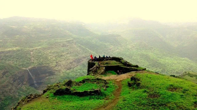
Rajmachi Fort is Located in the Sahyadri mountain range of Maharashtra, Rajmachi Fort is an iconic landmark that has captured the imagination of adventure enthusiasts, history buffs, and nature lovers alike. Perched at an altitude of 2,710 feet (826 meters) above sea level, this fort offers not only a peek into the rich historical past of India but also a refreshing escape into the wilderness. The fort is situated in the district of Raigad and is a popular destination for trekking, camping, and photography.

Whether you're planning a weekend getaway from Mumbai or Pune, Rajmachi Fort presents a perfect blend of history, adventure, and natural beauty. In this blog post, we'll take you through the details of this magnificent fort, including its history, trekking routes, best time to visit, and tips for a successful visit.

Rajmachi Fort

History of Rajmachi Fort

Rajmachi Fort has a deep-rooted connection with Maratha history. It is believed to have been built during the 17th century, either by the Chhatrapati Shivaji Maharaj or the Maratha rulers, although the exact timeline of its construction remains uncertain. The fort played a significant strategic role in controlling the trade routes in the region and served as an important military base during the Maratha Empire.

The fort consists of two main parts:

  1. Shrivardhan Fort: The larger of the two forts, located to the north.
  2. Manaranjan Fort: Positioned slightly to the south of Shrivardhan, it is smaller but offers breathtaking views of the surrounding landscape.

Both forts are connected by a ridge, and you can explore them both during your visit. The fortifications still display remnants of old structures, including bastions, gates, and water cisterns, which serve as silent witnesses to the centuries of history that have passed by.

During the British era, Rajmachi was an important military post, and it was used for surveillance and communication. After India’s independence, the fort largely fell into obscurity but remains a significant heritage site.

Rajmachi Fort

How to Reach Rajmachi Fort

Rajmachi Fort is accessible from two main routes, both offering their own unique experience:

1. Lonavala to Rajmachi

The most popular and accessible route begins from Lonavala, a well-known hill station located about 15 kilometers from Rajmachi. From Lonavala, you can either:

  • Drive to Rajmachi: A 14-kilometer drive on a dirt road (best suited for off-road vehicles). This route is accessible by private vehicles or taxis. The road offers a thrilling experience, especially during the monsoon when the entire area is lush and green.

  • Trek from Lonavala: The trek from Lonavala to Rajmachi is about 8 kilometers and takes around 4-5 hours. The trail goes through dense forests, scenic waterfalls, and villages. It is a moderate to challenging trek, particularly in the monsoon season when the terrain becomes slippery.

    Rajmachi Fort

2. Karjat to Rajmachi

Another popular route is from Karjat, a town located about 20 kilometers from Rajmachi. This route is a bit more challenging and less crowded than the Lonavala route but offers more secluded views of nature.

  • Trek from Karjat: The trek is about 12 kilometers long and takes 5-6 hours. The route passes through the scenic Ulhas River and offers a quieter experience compared to the Lonavala route.

Best Time to Visit Rajmachi Fort

  • Monsoon (June to September): If you're a fan of lush greenery and vibrant landscapes, visiting Rajmachi during the monsoon can be magical. The area is drenched in greenery, and the waterfalls along the trek route are in full flow. However, the trails can get slippery, and heavy rains may make the trek challenging, so only experienced trekkers should attempt this during this season.

  • Winter (November to February): The best time to visit Rajmachi for a pleasant trekking experience is during the winter months, when the weather is cool and the trails are dry. The temperature ranges between 10°C to 20°C, making it perfect for a comfortable trek and camping.

  • Summer (March to May): While it’s possible to visit Rajmachi in summer, the heat can make the trek tiring and challenging, especially for first-time trekkers. If you choose to visit during the summer, carry plenty of water and wear appropriate gear to combat the heat.

Trekking to Rajmachi Fort

The trek to Rajmachi Fort is a rewarding experience, with stunning views of the surrounding hills, valleys, and waterfalls. The terrain is varied, with some sections of the trail being rocky and others through dense forest cover.

  • Difficulty Level: The trek is considered moderate, but can be challenging during the monsoon due to slippery paths. It is suitable for first-time trekkers but requires a good level of fitness.

  • Duration: It typically takes 4 to 6 hours to ascend, depending on your fitness level and the starting point. The descent can take a little less time but should not be rushed.

  • Camping: For those who want to extend their adventure, camping near the fort is a popular option. There are ample spots around the fort to pitch a tent. The views from the campsite are breathtaking, especially at sunrise and sunset. Make sure to carry your own camping gear or opt for a guided camping experience.

  • What to Carry: Essential trekking gear includes comfortable shoes, water, a first aid kit, snacks, a raincoat (if traveling in the monsoon), and a camera to capture the stunning views.

Attractions Near Rajmachi Fort

While Rajmachi itself is a historical gem, there are several nearby attractions worth visiting:

  1. Lonavala: A short drive away, this popular hill station offers scenic spots like Bhushi Dam, Karla Caves, and Lion’s Point.

  2. Karla Caves: A set of ancient Buddhist rock-cut caves, which date back to the 2nd century BC. They are located near Lonavala and are famous for their intricate sculptures and inscriptions.

  3. Bhaja Caves: Another set of Buddhist rock-cut caves situated about 12 km from Lonavala, these caves are renowned for their historical significance and scenic beauty.

  4. Tungarli Lake: A serene lake near Lonavala, ideal for nature walks and peaceful picnics.

Tips for Visiting Rajmachi Fort

  • Start Early: To avoid trekking in the heat and to have ample time to explore the fort, start your trek early in the morning.

  • Check Weather Conditions: If you're planning to visit during the monsoon, be prepared for rain. Always check weather forecasts and trail conditions before heading out.

  • Local Guides: While the trek is manageable, hiring a local guide can enhance the experience, as they can share insights about the history of the fort and provide help navigating the trails.

  • Stay Hydrated: Carry sufficient water, especially during summer, as there are limited water sources on the way up.

  • Leave No Trace: Respect nature and keep the area clean. Carry back all your trash to preserve the pristine beauty of the region.

Conclusion

Rajmachi Fort stands as a symbol of Maharashtra’s rich historical and cultural legacy. Whether you're a history lover, an adventure seeker, or someone looking to connect with nature, the fort offers an enriching experience. Its strategic location amidst the Sahyadri hills not only provides a glimpse into India’s past but also rewards trekkers with panoramic views of the surrounding landscapes. So, pack your bags, put on your trekking shoes, and embark on a journey to this beautiful historical fortress.

Rajmachi Fort

Rajmachi Fort


Jul 29, 2021

The Dubai Frame: A Stunning Architectural Marvel

The Dubai Frame is One of Dubai's most captivating landmarks, the Dubai Frame is an architectural masterpiece that offers a unique perspective on the city's past, present, and future. Standing tall at 150 meters (492 feet), it is one of the tallest frames in the world and serves as a bridge between Dubai's historical roots and its cutting-edge modernity. As a symbol of the city's rapid transformation from a desert town to a global metropolis, the Dubai Frame is a must-see for tourists and a striking addition to Dubai’s ever-expanding skyline.
 
The Dubai Frame

Location and Design

Located in Zabeel Park, in the heart of Dubai, the Dubai Frame was designed by the renowned architect Fernando Donis, whose vision was to create a frame that would represent the union of past and future. The structure is shaped like a giant picture frame, with two 150-meter-high vertical towers connected by a horizontal glass bridge at the top. The Dubai Frame stands out as an innovative blend of modern architecture and cultural symbolism, combining both aesthetic beauty and historical meaning.

The Dubai Frame's design cleverly mirrors the idea of looking into a frame that captures views of the old and new Dubai. From the frame’s observation deck, visitors can witness the stark contrast between the historic parts of the city, with its traditional low-rise buildings, and the dazzling skyline of the modern metropolis, dominated by skyscrapers, luxury hotels, and cutting-edge architectural designs.

The Dubai Frame

 What to Expect When Visiting

Visiting the Dubai Frame is a multi-sensory experience that blends history, technology, and breathtaking views.

  1. The Ground Floor: History of Dubai Upon entering, visitors are greeted with an interactive exhibit that tells the story of Dubai’s rapid development, from a modest fishing village to a global hub for business, tourism, and innovation. Through multimedia displays, visitors learn about the city’s past, its cultural heritage, and the visionary plans that shaped its future.

  2. The Elevators To reach the top of the frame, visitors ride high-speed elevators, which take you up to the observation deck in under a minute. These glass-walled elevators offer panoramic views of Dubai as they ascend, giving visitors a preview of the stunning vistas awaiting them at the top.

  3. The Observation Deck: Views of Old and New Dubai The main highlight of the Dubai Frame is the panoramic observation deck at the top. This glass bridge provides a bird’s-eye view of both sides of the city, allowing visitors to compare the old and new Dubai:

    • Old Dubai (to the north): On one side, you can look out towards the historic districts, such as Al Fahidi and Al Seef, with their traditional wind towers and narrow streets. This side offers a glimpse into the Dubai of the 1960s and 1970s, when the city was primarily known for its pearl diving, fishing, and trade.

    • New Dubai (to the south): On the other side of the frame, you can marvel at the contemporary Dubai skyline, featuring iconic structures like the Burj Khalifa, Dubai Mall, Jumeirah Beach, and the Palm Jumeirah. The contrast between the two sides symbolizes Dubai's rapid modernization and its role as a global leader in business, innovation, and tourism.

      The Dubai Frame

  4. The Glass Bridge: A Thrilling Experience For those who aren’t afraid of heights, the Glass Bridge is a thrilling feature of the Dubai Frame. Situated at the top of the structure, the bridge allows visitors to walk on transparent glass floors, offering an exhilarating view straight down to the ground below. It’s a unique experience that gives you the sensation of floating above the city, offering both excitement and a sense of awe.

  5. The Museum: Future Dubai After you’ve enjoyed the views, visitors can descend to the museum at the base of the frame, which showcases what Dubai will look like in the future. Through interactive displays, augmented reality, and futuristic concepts, this exhibit highlights the city’s ambitions for sustainability, innovation, and smart technology. It’s a glimpse into the city’s future plans, with projects like smart cities, autonomous transport, and eco-friendly solutions taking center stage.

The Significance of the Dubai Frame

The Dubai Frame is more than just an architectural wonder it holds great symbolic value for the city. It serves as a visual representation of the connection between past and future. By framing both the old and the new Dubai in one structure, it invites visitors to reflect on the city’s transformation over the years.

  • Cultural Symbolism: The Dubai Frame stands as a metaphor for Dubai’s transition from a modest trading port to a global city, demonstrating how innovation and forward-thinking can reshape a nation's identity.

  • Global Recognition: It is also a testament to Dubai's status as a city that leads the way in architectural excellence. It joins other iconic landmarks such as the Burj Khalifa and Palm Jumeirah, showcasing Dubai's commitment to pushing the boundaries of design and engineering.

Practical Information for Visitors

  • Opening Hours: The Dubai Frame is typically open daily from 9:00 AM to 9:00 PM, with extended hours during weekends or public holidays. It’s always a good idea to check the official website for the latest information.

  • Ticket Prices: Admission to the Dubai Frame is reasonably priced, with discounts available for children, students, and seniors. As of now, general admission is around AED 50 for adults and AED 20 for children. Special packages or tours may have varying prices.

  • Accessibility: The Dubai Frame is wheelchair accessible, with dedicated facilities for people with disabilities. The structure has ramps, elevators, and seating areas to ensure all visitors can enjoy the experience.

Best Time to Visit

The best time to visit the Dubai Frame is during the cooler months, from November to March, when the weather in Dubai is more pleasant. Visiting during the early morning or late afternoon is ideal to avoid crowds and enjoy the views during golden hour, as the sunlight casts a beautiful glow over the city.

Conclusion

The Dubai Frame is a must-visit attraction for anyone exploring Dubai. Whether you're fascinated by history, architecture, or technology, this incredible structure offers something for everyone. It’s a place where you can reflect on Dubai's remarkable past, marvel at its present, and imagine what the future holds for this innovative city. With its stunning views, interactive exhibits, and striking design, the Dubai Frame perfectly encapsulates the essence of a city that is constantly evolving and reaching new heights.

So, next time you're in Dubai, make sure to look up and experience the city in a whole new way through the lens of the Dubai Frame.


The Dubai Frame
 
The Dubai Frame

The Dubai Frame

The Dubai Frame

Jul 21, 2021

A Comprehensive Guide to Auroville: The City of Dawn

Auroville is Nestled in the serene landscape of Tamil Nadu, India, Auroville is a unique experimental township founded on the principles of human unity and sustainable living. Established in 1968 by Mirra Alfassa, also known as "The Mother," Auroville was envisioned as a place where people of all nationalities, religions, and backgrounds could live together in peace and harmony, transcending the limitations imposed by traditional boundaries of race, religion, and nationality.

Auroville’s development is rooted in the spiritual and philosophical teachings of Sri Aurobindo, an Indian philosopher and yogi. The town has since become a global symbol of a progressive and conscious way of life, blending modern science with spirituality, sustainability with innovation.

This article takes you through the history, principles, attractions, and practical aspects of Auroville, providing insights into what makes this international community so special.

Auroville

The Vision and Philosophy Behind Auroville

At the heart of Auroville lies the vision of creating a "universal town" a place where people can freely experiment with alternative ways of living, working, and interacting with the environment. The underlying goal is to foster an environment where human beings can realize their fullest potential, both individually and collectively.

The Mother’s vision for Auroville was to create a "city of dawn" (Auroville literally means “The City of Dawn” in French), a place where the sun of human unity could rise. The township was designed to be a model of human collaboration, where people would live not for personal gain or profit, but for the collective good.

Key principles include:

  • Unity of all humans: Auroville strives to unite people from diverse backgrounds, fostering mutual respect and collaboration.
  • Spiritual evolution: Auroville is not just a physical space but a spiritual one, where people pursue inner growth and self-realization.
  • Sustainability: From ecological preservation to renewable energy and organic farming, Auroville seeks to develop solutions for a sustainable future.
  • Educational experimentation: Auroville has established several educational institutions that embody progressive and holistic approaches to learning.
The Architecture of Auroville

Auroville’s architecture is as innovative as its philosophy. Designed to blend seamlessly with nature, the town avoids rigid, traditional urban structures. Its buildings are made from natural, locally sourced materials such as clay, sand, and stone, and many of them are built using ecological construction techniques that promote energy efficiency and sustainability.

 The Matrimandir

The centerpiece of Auroville is the Matrimandir, a stunning spherical structure that symbolizes the spiritual heart of the town. The Matrimandir is often referred to as the "soul of Auroville." It is a meditation center, designed to help people connect with their inner selves. The building is made of marble, with a golden globe at its center. The dome’s interior contains a crystal sphere, and it is bathed in natural light, which creates a serene, almost otherworldly atmosphere.

Visitors to the Matrimandir must first attend an orientation session to enter, as it is a place dedicated to silent meditation and reflection.

Community Buildings and Sustainable Architecture

Throughout Auroville, the buildings are designed to respect the local environment. Many are constructed using mud and other sustainable materials, while renewable energy sources such as solar and wind power are incorporated into the design of buildings. The town's layout encourages community interaction and connection with nature, with pedestrian paths, organic gardens, and tree-lined avenues.

The Community Life of Auroville

Auroville is home to over 2,800 residents, representing more than 50 nationalities. The residents, known as "Aurovilians," live and work together without formal ownership of property. Instead, they contribute to the collective life based on their skills and talents, with each resident participating in a community-based, egalitarian lifestyle.

Auroville

Auroville has a decentralized administrative structure, with multiple committees and working groups that manage everything from finances to education to environmental initiatives. There is no central authority or hierarchy in Auroville; rather, decision-making is based on consensus and cooperation.

The town has no currency in the traditional sense. Instead, Auroville runs on a system of "Auroville units" (AVUs), an internal currency that helps fund community activities, goods, and services. These units are exchangeable for goods and services within Auroville but are not used outside the township.

Cultural and Social Activities

Auroville is a thriving cultural hub with a diverse range of activities, from music and art festivals to yoga and meditation classes. The community places a strong emphasis on creativity and spiritual development, making it a space where individuals can explore their artistic, intellectual, and emotional potential.

Sustainability and Environmental Projects in Auroville

Auroville is an ecological experiment in itself, with a range of initiatives focused on sustainability, green energy, organic farming, and water conservation. The town’s commitment to ecological balance is evident in its many projects.

Agriculture and Organic Farming

Auroville promotes organic farming as a core principle. Many farms within Auroville grow a variety of crops, from vegetables to fruit trees, using permaculture principles and sustainable practices. The farms also serve as educational centers, where Aurovilians and visitors can learn about sustainable agricultural techniques.

Auroville

Solar and Wind Power

One of Auroville’s standout features is its use of renewable energy. The town is powered largely by solar panels and wind turbines, and it has various energy-efficient buildings. The goal is to reduce reliance on conventional electricity sources and create a model of energy self-sufficiency.

Water Conservation and Management

Given the semi-arid climate of Tamil Nadu, water conservation is a critical issue. Auroville has implemented various techniques for rainwater harvesting, wastewater treatment, and sustainable irrigation systems to ensure that water is used efficiently and responsibly.

Living and Visiting Auroville: Practical Aspects

How to Live in Auroville

To become a resident of Auroville, individuals must first apply for a visitor’s pass. This allows them to stay for a period of time (usually a few weeks) and get to know the community and its activities. If a visitor feels drawn to stay longer, they can apply to become a "newcomer," a status that provides an opportunity to integrate into Auroville more fully. The process of becoming a full member takes time and involves contributing to the community through work, service, and participation in communal life.

Auroville

Visiting Auroville

Auroville is open to visitors who wish to explore its unique culture, philosophy, and sustainability initiatives. The town welcomes tourists for day trips, where they can take guided tours, visit the Matrimandir, explore the organic shops, or participate in workshops related to yoga, art, and environmentalism. The Visitor’s Center is the main entry point for anyone wanting to explore Auroville’s attractions and learn about its history.

Accommodations and Food

There are several guesthouses and eco-friendly accommodation options in and around Auroville, ranging from simple, community-run rooms to more comfortable lodgings. Dining in Auroville is also unique many of the town’s restaurants and eateries serve organic, vegetarian food made with locally grown produce. There are also cafés offering a mix of international and Indian cuisines.

Documentary of Auroville

At present, any filming within and about Auroville requires land permission from the Government of India. Many filmmakers visit Auroville, and a wide range of films are available. These include:

  • Ever Slow Green - Re-afforestation in Auroville, South India, full length, 56 minutes, 2020 
  • City of the Dawn, full length, 80 minutes, 2010 
  •  Auroville, the outline of a world, full length, 25 minutes, 2009 
  •  Auroville – A Dream of the Divine (part 1 and 2), full length, 20 minutes in two parts, 2003 
  • Spiritual journey... Auroville (Духовное путешествие... Ауровиль), six 25-minute videos on Auroville by Russian filmmakers, 2013 
  • The India Trip full length, 49 minutes, from the National Film Board of Canada, 1971

Auroville topics can also be heard on Auroville Radio, and the films about Auroville screened at the biennial Auroville Film Festival.

Conclusion: Auroville as a Beacon of Hope

Auroville represents an ideal of human unity and sustainable living in a world that often feels divided by borders, ideologies, and materialism. It is a testament to the possibility of creating a society based on cooperation, ecological harmony, and spiritual growth. While Auroville’s journey is ongoing, it continues to inspire thousands of people around the world who visit, live, or engage with its principles and vision.

For anyone seeking a place of peace, introspection, and connection, Auroville offers an unparalleled opportunity to explore a truly transformative way of life. 

If you're intrigued by Auroville and want to experience it for yourself, plan a trip to Tamil Nadu. Whether you're a traveler, a spiritual seeker, or someone passionate about sustainability, Auroville offers a refreshing glimpse into a future where human beings live harmoniously with each other and the Earth.

Auroville

Jul 15, 2021

The Mystical Catatumbo Lightning: A Natural Wonder

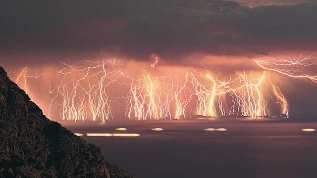
If you've ever seen a thunderstorm so intense it seemed to light up the sky like a strobe light on steroids, you're not alone, but few places in the world experience anything quite like the Catatumbo Lightning. Occurring at the confluence of the Catatumbo River and Lake Maracaibo in Venezuela, this spectacular meteorological phenomenon is one of Earth's most mesmerizing natural wonders. It is unique not only for its incredible intensity but also for its predictability and frequency. Here's everything you need to know about this awe-inspiring display of nature's power.

Catatumbo Lightning

What is Catatumbo Lightning?

Catatumbo Lightning refers to the continuous lightning storms that occur in a specific region near Lake Maracaibo. The phenomenon is characterized by frequent, intense thunderstorms, which happen almost nightly for much of the year. This lightning is unusual because it strikes the same place over and over again, often creating a steady, flashing illumination in the sky. The storms can last for hours, with frequent lightning strikes that light up the night sky, creating an otherworldly spectacle.

Why the Name "Catatumbo"?

The phenomenon takes its name from the Catatumbo River, which flows into Lake Maracaibo. The word “Catatumbo” comes from the indigenous Barí language, referring to a place near the river’s mouth.

Where Does Catatumbo Lightning Occur?

Catatumbo Lightning is found around the Lake Maracaibo Basin in western Venezuela. It primarily occurs near the mouth of the Catatumbo River, where it flows into the lake. The lightning strikes are most concentrated in an area approximately 200 square miles (500 square kilometers). The closest city to the event is Ciudad Bolívar, but it is most clearly observed from a boat on Lake Maracaibo or from elevated areas around the lake.

Catatumbo Lightning

How Often Does It Happen?

One of the most astonishing things about Catatumbo Lightning is its frequency. This area experiences lightning storms for approximately 140 to 160 nights per year, or about 10 hours per night. On average, there are 28 lightning strikes per minute during the storms, producing more than 1,200 strikes per hour during peak times. In total, the storms can generate between 10 to 20 strikes per second.

This extreme level of consistency has made Catatumbo Lightning one of the most predictable lightning phenomena on Earth.

What Causes Catatumbo Lightning?

The causes of Catatumbo Lightning are complex and involve a combination of local geography, atmospheric conditions, and wind patterns. Here’s a simplified breakdown of the science behind this phenomenon:

  1. Topography of the Region: The area is surrounded by mountains to the north, which trap moist air from the Caribbean Sea. The warm, moist air rises and cools as it moves over the mountains, creating the ideal conditions for thunderstorms.

  2. Unique Wind Patterns: The combination of winds from the Caribbean and winds from the mountains causes a collision of air masses. The moist, warm air from the lake meets the cooler air from the mountains, creating intense thunderstorms.

  3. High Humidity: The region experiences extremely high humidity, as the moist air from the lake and surrounding wetlands contributes to the storm formation. This excessive moisture can result in a build-up of electric charge in the atmosphere, which is eventually released as lightning.

    Catatumbo Lightning

  4. Turbulent Weather: The convergence of warm and cold air masses creates turbulence, which in turn promotes the rapid buildup of electrical charges in the clouds. When these charges reach a critical point, they discharge as a lightning strike.

How Intense Is the Lightning?

Catatumbo Lightning is not just a casual light show. The intensity of the strikes is extraordinary. In fact, the lightning that occurs in this region is among the strongest and most energetic on Earth. The bolts can be up to 5 miles (8 kilometers) long, and the brightness is so intense that it can light up the night sky as brightly as daylight for a short period of time. The intensity of the storms can reach up to 1,000 times more powerful than an average lightning strike, releasing massive amounts of energy.

The Role of Catatumbo Lightning in the Environment

Interestingly, Catatumbo Lightning may play an important ecological role in the region. It is believed to help replenish ozone levels in the atmosphere. Some scientists have suggested that the lightning storms contribute to the formation of ozone (O₃), an important compound that protects life on Earth by filtering ultraviolet radiation. The sheer frequency of lightning may be a natural way of maintaining the ozone layer.

Additionally, the region is rich in methane gas emissions, and the lightning may help to break down methane molecules, reducing their presence in the atmosphere. This process is believed to play a small but potentially significant role in controlling global warming.

Why Is Catatumbo Lightning So Special?

Several factors make Catatumbo Lightning extraordinary:

  1. Unique Location: Few places on Earth have a lightning phenomenon as regular and intense as Catatumbo. While thunderstorms occur around the world, no other location experiences this level of frequency, duration, or intensity.

    Catatumbo Lightning

  2. Scientific Mystery: Despite much research, scientists are still working to understand all the factors behind this incredible phenomenon. The exact mechanisms behind the frequency and regularity of the lightning are still not entirely understood.

  3. Cultural Significance: For locals and indigenous people, the Catatumbo Lightning is more than just a weather event; it's a cultural symbol. The phenomenon has been passed down through generations as an awe-inspiring spectacle, often viewed as a sign of the power of nature and a connection to the divine.

  4. Global Attention: With its uniqueness, the Catatumbo Lightning has become a tourist attraction. The region’s nightly lightning displays draw photographers, storm chasers, and adventurers from around the world, eager to witness one of nature’s most impressive spectacles.

How to Experience Catatumbo Lightning

If you're planning to witness Catatumbo Lightning, it’s best to visit during the rainy season, which lasts from May to November. The best viewing areas are on the waters of Lake Maracaibo or the surrounding highlands, where the storms are most visible. Keep in mind that the lightning is often best seen from a distance, as getting too close to the storms can be dangerous due to the possibility of lightning strikes.

Travel Tip: Book a boat tour or a local guide who is familiar with the best vantage points. Keep in mind that lightning storms can be unpredictable, and sightings are never guaranteed. But for those who are lucky enough to witness the phenomenon, it is an experience they will never forget.

Catatumbo Lightning

Conclusion

Catatumbo Lightning is a true marvel of nature, a stunning and surreal display of electrical energy that occurs with a regularity and intensity few places on Earth can rival. Whether you’re a storm chaser, a photographer, or simply someone in awe of the raw power of nature, the Catatumbo Lightning is an unforgettable sight that reminds us of the grandeur and mystery of our planet.

Catatumbo Lightning

Catatumbo Lightning

Jul 14, 2021

The Svalbard Global Seed Vault: A Guardian of Earth's Genetic Heritage

The Svalbard Global Seed Vault is often described as the "Doomsday Vault" or the "Noah’s Ark of Seeds" and for good reason. Nestled in the frigid wilderness of Svalbard, a remote archipelago in the Arctic Ocean, this extraordinary facility stands as humanity's backup plan for securing the genetic material of the world’s crops against the most catastrophic events imaginable. It's not just a collection of seeds it's an emergency seed bank, a genetic reservoir that could play a vital role in the future of agriculture, biodiversity, and global food security.

The Svalbard Global Seed Vault

In this blog, we will delve deeply into the Svalbard Global Seed Vault, examining its purpose, structure, operations, and the critical role it plays in protecting the world's agricultural biodiversity.

Purpose and Global Significance

The Svalbard Global Seed Vault serves a singular yet profound purpose: to safeguard the genetic diversity of global crops. Genetic diversity in agriculture is vital for breeding crops that can withstand diseases, pests, and changing environmental conditions, particularly as climate change accelerates. A loss of this diversity could lead to the collapse of food systems and the erosion of resilience against future agricultural challenges.

The Svalbard Global Seed Vault

Key Objectives of the Seed Vault:

  • Preserve biodiversity: By storing seeds from a wide variety of plant species, the Vault helps ensure that the genetic pool of crops can be replenished, should disaster strike.
  • Emergency backup: The facility acts as an emergency backup for national seed banks and other agricultural institutions worldwide, ensuring that crops can be regrown and re-bred in the event of widespread devastation.
  • Protection from global threats: This includes threats like climate change, natural disasters, wars, pests, and disease outbreaks, all of which could severely disrupt food production and food systems.

Key Players Involved:

  • Norway’s government: Provides funding and oversight for the facility, along with the necessary infrastructure.
  • Crop Trust: An international organization that partners with various entities to manage the vault, ensuring it remains a viable resource for the long term.
  • NordGen: The Nordic Genetic Resource Center, based in Sweden, works to facilitate seed collection and storage.

Location: Why Svalbard?

The strategic location of the Svalbard Global Seed Vault is one of its key advantages. Located in Longyearbyen, on the island of Spitsbergen, Svalbard is part of Norway’s territory and lies deep within the Arctic Circle. There are several factors that make Svalbard an ideal location for such a critical facility:

Geographical and Climatic Benefits

  • Permafrost: The deep, naturally occurring permafrost in Svalbard acts as a built-in refrigeration system. This permafrost, which is frozen year-round, keeps the seeds at an optimal storage temperature of around -18°C (0°F), without the need for excessive energy input.
  • Stable, cold environment: The cold, stable climate and remote location mean that seeds stored in Svalbard can be kept frozen for thousands of years, offering natural long-term preservation. Even if the facility loses power or experiences technical issues, the seeds will remain viable thanks to the permafrost.

Political Stability

  • Norwegian sovereignty: Norway is politically neutral and stable, ensuring that the Seed Vault remains safe from political conflict and international disputes. Additionally, Norway has committed to maintaining the Seed Vault for the long-term benefit of humanity, free from military or geopolitical influences.

Strategic Accessibility

  • Remote but accessible: While Svalbard is geographically isolated, it is still relatively easy to access by air from mainland Europe. This accessibility allows for regular seed shipments and occasional seed retrievals, even in extreme conditions.

Design and Structure of the Vault

The Seed Vault is built into the side of a mountain at a high elevation, carved deep into rock and surrounded by layers of permafrost. Its design is not only functional but also built to withstand the test of time, even in the face of unforeseen natural disasters or human-made threats.

The Svalbard Global Seed Vault

Key Design Features:

  • Tunnels and Chambers:

    • The main building consists of a long, 120-meter (394-foot) tunnel cut into the rock. This tunnel leads to a series of cold storage chambers where the seeds are stored. These chambers are separated to ensure that seeds from different regions and plant species are kept isolated from each other to prevent cross-contamination.
  • Temperature and Humidity Control:

    • Inside the chambers, the seeds are stored at -18°C. The cold temperature ensures that the seeds remain dormant and viable for the long term. Low humidity is also maintained to prevent mold or mildew, which could degrade the seeds over time.
  • Security:

    • The Seed Vault is designed with multiple layers of security, both physical and digital, to prevent unauthorized access. The facility includes high-tech surveillance systems, secure access points, and a combination of electronic and mechanical locks to ensure that only authorized personnel can access the seeds.
  • Sustainability:

    • The building's energy efficiency is enhanced by its location in the permafrost and its use of solar panels. While the cold naturally preserves the seeds, there is also a backup power system to ensure that the Vault remains operational even in the event of a power outage.

Seed Storage: How the Vault Works

The primary function of the Svalbard Global Seed Vault is to provide a secure, long-term storage solution for seeds that might otherwise be lost in times of crisis.

The Svalbard Global Seed Vault

How Seeds are Collected and Stored:

  • Seed Deposits: Institutions such as national seed banks, agricultural research centers, and gene banks contribute seeds to the Vault. These seeds are collected from a broad range of crop species and varieties, representing the genetic diversity that sustains global food production.

  • Seed Packages: Each seed collection is sealed in airtight, durable aluminum foil packets to protect them from external contaminants like moisture and bacteria. The packets are labeled with the species name, collection details, and geographical origin.

    • The seeds are typically dried before being stored to reduce moisture content, which helps preserve them and prevents germination.
  • Long-term Preservation: Inside the Seed Vault, the temperature is maintained at -18°C (-0.4°F), which is an optimal condition for preserving the seeds’ germination potential for centuries. In fact, seeds stored at this temperature can remain viable for hundreds or even thousands of years. This allows the vault to act as a sort of "time capsule" for the world’s biodiversity.

  • Quantity and Diversity: As of 2024, the Seed Vault contains over 1 million seed samples, including species of essential food crops like wheat, corn, rice, barley, beans, and potatoes, as well as less common species important to regional diets and ecosystems. At full capacity, it can hold up to 4.5 million seed samples.

    The Svalbard Global Seed Vault

Real-World Impact: Crisis Response and Seed Retrieval

Though the Svalbard Global Seed Vault was created as a precautionary measure, it has already been called into action a few times to provide seeds during periods of crisis.

Syria’s Request for Seed Retrieval (2015)

In 2015, the first-ever seed withdrawal from the Vault occurred when Syria’s national seed bank was destroyed due to the ongoing civil war. The war had not only devastated the country's agricultural infrastructure but also its seed collection. The Svalbard Vault responded by sending backup seeds, ensuring that Syria's farmers could continue to plant essential crops.

Other Potential Crisis Scenarios

  • Natural Disasters: Countries like the Philippines, which are frequently affected by typhoons, or areas in sub-Saharan Africa, which experience prolonged droughts, could benefit from the Seed Vault's reserves in times of crisis.
  • Pests and Diseases: The Seed Vault can be used to restore crops wiped out by plant diseases (e.g., wheat rust or potato blight) or pests like the fall armyworm that devastate corn crops in sub-Saharan Africa.

Future Challenges and Sustainability

As the global population grows and the effects of climate change become more pronounced, the role of the Seed Vault will continue to evolve. The facility must adapt to new challenges, such as preserving seeds from genetically modified organisms (GMOs), ensuring that seeds can be accessed efficiently, and improving international collaboration on crop preservation efforts.

Future Goals and Plans

  • Expansion of seed collection: More diverse crops, particularly those adapted to changing climates, need to be collected and preserved.
  • Technological innovation: The Vault may incorporate even more sophisticated preservation technologies to ensure the seeds remain viable over millennia.

Conclusion: A Legacy for Future Generations

The Svalbard Global Seed Vault represents a profound commitment to preserving the planet's agricultural diversity for future generations. As climate change, geopolitical instability, and other environmental challenges threaten global food security, the Seed Vault stands as an essential safeguard, ensuring that humanity will always have the means to regrow and adapt crops as needed.

In the face of uncertainty, the Seed Vault offers hope—a tangible, long-term solution that transcends borders, helping to protect the future of food on a global scale.


The Svalbard Global Seed Vault

The Svalbard Global Seed Vault


The Svalbard Global Seed Vault

The Svalbard Global Seed Vault

The Svalbard Global Seed Vault