Apr 18, 2021

Ilha da Queimada Grande (Snake Island), Island off the Coast of Brazil, Atlantic Ocean, Brazil

Ilha da Queimada Grande, also known as Snake Island, is an island off the coast of Brazil in the Atlantic Ocean. It is administered as part of the municipality of Itanhaém in the State of São Paulo. The island is small in size, only 43 hectares (106 acres), and has a temperate climate. The island's terrain varies considerably, ranging from bare rock to rainforest.

The island is the only home of the critically endangered, venomous Bothrops insularis (golden lancehead pit viper), which has a diet of birds. The snakes became trapped on the island when rising sea levels covered up the land that connected it to the mainland. The ensuing selection pressure allowed the snakes to adapt to their new environment, increasing rapidly in population and rendering the island dangerous to public visitation.


Queimada Grande is closed to the public in order to protect both people and the snake population; access is only available to the Brazilian Navy and selected researchers vetted by the Chico Mendes Institute for Biodiversity Conservation, the Brazilian federal conservation unit.

Located approximately 33 kilometres (21 mi) off the coast of the state of São Paulo, Brazil, the island is approximately 430,000 square metres (110 acres) in area. The island ranges in elevation from sea level to 206 metres (676 ft) above sea level. The island has a temperate climate that is similar to its neighbouring island Nimer. 0.25 square kilometres (62 acres) of the island is covered by rain forest; the remaining areas consist of barren rocks and open grassland. Queimada Grande ranges from an average of 18.38 °C (65.08 °F) in August to 27.28 °C (81.10 °F) in March, and rainfall ranges from 0.2 millimetres (0.0079 in) per month in July to 135.2 millimetres (5.32 in) in December.

Ilha da Queimada Grande has a variety of vegetation. The island is  partly covered in rainforest and partly bare rock and grassy cleared areas, a result of  deforestation. The deforestation is the origin of the island's name: the  term "Queimada", in Portuguese, means “burnt” because when locals attempted to clear land  for a banana plantation on the island, they had to clear rain forest using this technique. A  lighthouse was constructed in 1909 to steer ships away from the island. The last human  inhabitants left the island when the lighthouse was automated.


The island and the Ilha Queimada Pequena to the west are protected  by the 33 hectares (82 acres) Ilhas Queimada Pequena e Queimada Grande Area of Relevant   Ecological Interest, created in 1985. The Brazilian Navy has closed the island to the public and the only people who are allowed on the island are research teams who receive waivers  to collect data.

Because there are so many snakes on one island, by some estimates  one snake to every square meter (10.8 square feet) of the island, there is competition for  resources. Despite a population of 41 recorded bird species on Queimada Grande, the  golden lancehead relies on only two: the Troglodytes musculus (the southern house wren),  which is usually able to avoid the golden lancehead as a predator, and the Chilean elaenia  (a species of flycatcher), which feeds on vegetation in the same area as the snake.

The island was thought to have a population of about 430,000 snakes, but recent estimates are much lower. The first systematic study of the population of the golden lancehead found the population to be 2,000 to 4,000, concentrated almost entirely in the rainforest area of the island. This might have happened because there was a limited amount of resources and the population became level, but in 2015 an estimate by a herpetologist on a Discovery Channel documentary stated that the population remains at 2,000 to 4,000 golden lanceheads. The Bothrops insularis also may be at risk from inbreeding, effects of which are evident in the population.

Because of the overall low population of the golden lancehead, the snake was labelled critically endangered on the IUCN Red List of Threatened Species. It also was placed on the list of Brazil's endangered animals. The island is also home to a smaller population of Dipsas albifrons, a non-venomous snake species.

Apr 17, 2021

Oymyakon village ( World's Coldest Permanently Inhabited Place on Earth), Oymyakonsky District of the Sakha Republic, Russia

Oymyakon village is in eastern Siberia is closer to the Arctic Circle than it is to the nearest city. A monument in the town square commemorates the day in 1924 when the temperature fell to a record 96 degrees below zero Fahrenheit. Oymyakon, north of the Sea of Okhotsk, is the coldest permanently inhabited place on earth. Oymyakon is a rural locality (a selo) in Oymyakonsky District of the Sakha Republic, Russia, located along the Indigirka River, 30 kilometers (19 mi) northwest of Tomtor on the Kolyma Highway. By winter average temperatures, it is the coldest permanently inhabited settlement on Earth.

It is named after the Oymyakon River, whose name reportedly comes from the Even word kheium, meaning "unfrozen patch of water; place where fish spend the winter". However, another source states that the Even word heyum (hэjум) (kheium may be a misspelling) ,which means "frozen lake", may be where it gets its name. Oymyakon has two main valleys beside it. These valleys trap wind inside the town and create the colder climate. The temperatures here are extremely cold throughout the year, and it snows frequently. Schools are closed if it is colder than −55.0 °C (−67.0 °F).


The tall concrete statue of a huge bull in the center of town marks  the coldest temperature to be ever recorded in any inhabited place on earth. Ironically, the  meaning of Oymyakon in Russian is “water that doesn’t freeze.” The settlement was  established in the 1920s when the winter herders would water their reindeer at a thermal spring over  there and thought it would be ideal for them to settle in.

Over the last few decades, the population of Oymyakon has shrunk significantly. The village had a peak population of roughly 2,500 inhabitants, but that number has decreased to fewer than 900 in 2018. With an extreme subarctic climate, Oymyakon is known as one of the places considered the Northern Pole of Cold, the other being the town of Verkhoyansk, located 629 km (391 mi) away by air. The ground is permanently frozen.

There is a monument built around the town square commemorating a reading in January 1924 of −71.2 °C (−96.2 °F). This was shown on the Australian program 60 Minutes in a 2012 documentary.On 6 February 1933, a temperature of −67.7 °C (−89.9 °F) was recorded at Oymyakon's weather station.This was the coldest officially recorded temperature in the Northern Hemisphere. Only Antarctica has recorded lower official temperatures (the lowest being −89.2 °C (−128.6 °F), recorded at Vostok Station on 21 July 1983).

The weather station is in a valley between Oymyakon and Tomtor. The station is at 750 m (2,460 ft) above sea level and the surrounding mountains, at 1,100 m (3,600 ft), cause cold air to pool in the valley: in fact, recent studies show that winter temperatures in the area increase with altitude by as much as 10 °C (18 °F).

Some years the temperature drops below 0 °C (32 °F) in late September and may remain below freezing until mid-April. In Oymyakon sometimes the average minimum temperature for December, January, and February remains below −50 °C (−58 °F). Sometimes summer months can also be quite cold, but June, July and August are the months where the temperature has never dropped below −14 °C (7 °F). Oymyakon and Verkhoyansk are the only two permanently inhabited places in the world that have recorded temperatures below −60.0 °C (−76 °F) for every day in January. The climate is quite dry, but as average monthly temperatures are below freezing for seven months of the year, substantial evaporation occurs only in summer months. Summers are much wetter than winters.

Temperature in Oymyakon goes down below zero during most part of the year and the average temperature in the town falls to -58 degrees Celsius in the winters. There comes a time when the temperature reaches a point where the brain goes numb, people keep the engines of their vehicles running 24/7 and eat heavy meat products to stay alive! But human brains work quite differently; they have come up with myriad tricks to survive the cold in their town.


Residents here use outhouses as indoor  plumbing freezes most of the time. Pipes freeze, leading to outhouses. The cold sometimes  gets so unbearable that your eyelashes and saliva will freeze into painful little needles on your  face as you walk down the street. This happens only very rarely and is not of a concern  if you are not wandering about the town for long hours. Even vodka or any alcohol for that matter will freeze if a bottle is left outside.They have heated garages to keep the  cars. Farming is not possible on the frozen land so folks mainly survive on a carnivorous  diet. If you ever plan to visit this place, you’ll get reindeer meat and frozen fish as local  delicacies. Another prominent cuisine of the place is ice cubes made using horse blood served  with macaroni. All these are absolutely must have to survive in this cold place.

But then at the end of every dark winter completed, the town hosts the “Cold Pole Festival,” which is hosted by Chyskhaan which is a pagan spirit that the Yakutians celebrate. He invites the whole world into his frigid domain every year in March for reindeer races, dog sledging, ice fishing, and other merry activities that all local participate in. But since Oymyakon is a two-day long drive from Yakutsk, the nearest airport, the prospect of reaching the place can be tiresome for some but for the adventure hearted, it will be exciting and fun.

Apr 16, 2021

Stuðlagil Canyo (A Gem OF Iceland), East Iceland, Jökuldalur, Iceland

Stuðlagil Canyon can be found in East Iceland in the Glacier Valley called Jökuldalur. Stuðlagil Canyon is at plateaus of East Iceland, not far from the black beaches of the Eastfjords. The closest major town is Egilsstaðir, 44 miles (72 km) to the east. The canyon is 371 miles (597 km) from Reykjavik and 130 mi (210 km) from Akureyri. With the largest number of basalt rock columns in Iceland and a stunning blue glacier river to contrast, Stuðlagil is one of Iceland's hidden gems. Stuðlagil Canyon was created when the force of a river so powerful they named it thrice (Jökla, Jökulsá á Brú and Jökulsá á Dal) forced its way from the Highlands to the North of the island. The force of this glacial river, which is 150km long, and the water level was such that the area was considered dangerous for a long time. As a result, the area around the canyon was inhabited only by sheep. 

The canyon is dominated by stunning hexagonal basalt columns. These columns are unerringly uniform in appearance. They look man made, rather than the result of solidified lava and formation of centuries. The canyon was completely submerged under the river Jökla. A few years ago, the water level of the river fell and revealed the canyon in all its glory. The Jökla is now a force of clarity and color. Previously, the water was sourced by glacial sediment, turning it a murky brown color. Now the river is fed by the crystal-clear waters of Hálslón Reservoir. As a result, the waters that flow through Stuðlagil Canyon are a vibrant turquoise.

The river Jökla was once so fierce that it divided Jökuldalur Valley into two parts. Farmers and villagers on either side were completely cut off from each other. To solve this problem, locals built a dam across the river, causing the water level to fall. With the introduction of a nearby hydroelectric plant called Kárahnjúkavirkjun in 2009, the landscape of the area drastically changed. Hálslón was created in Eastern Iceland as a vast reservoir for water.

The water level decreased and with the hydroelectric plant harvesting the force of the water, the river was less fierce. This was a huge scale project at the time to provide the aluminium plant in Reyðarfjörður with electrical power. Now, that the water has calmed and the level reduced, this natural beauty is receiving a lot more attention from travellers and locals alike. There is a beautiful waterfall called Stuðlafoss (which translates as Basalt Column Waterfall) in Upper Jökuldalur. This is worth a visit if you have the time.

The terrain around the canyon is still relatively untouched and like most of Iceland, the facilities are not in place. The terrain is loose underfoot in places, so hiking boots are advised. Be mindful of nesting birds, particularly in the Spring and Summer. Pink-footed geese, for example, lay their eggs along the gorge in May and June so be extra cautious around this time. It was so strong that it divided the valley Jökuldalur into two separate parts that didn't have much communication for centuries. It was a river that was both dangerous and difficult to cross. It was the only river in Iceland that became known by its nickname rather than either of its real names.


Stuðlafoss Waterfall, also known as the Basalt Column Waterfall, flows into a branch of the Jökla. The cascade pours down from moss-covered basalt columns.The spectacular choppy columns of  Stuðlafoss resemble an ancient throne. Visiting the beautiful basalt waterfall, you’ll feel as if you’ve discovered a forgotten corner of the world. 

Access to Stuðlagil is relatively straightforward, but there are two options-

The First option where you can drive to the farm Grund and view the canyon from the west side of the canyon and the river. After turning south on Ring Road nr. 1 by Skjödólfsstaðir to road nr. 923, you drive to the farm Grund about 19 kilometers. At the farm, you will find a parking lot. Of the two viewing options, the west side is much less exciting and gives a minimal overview of the canyon.  The observation platform is oddly placed, has too many steps, and is not interesting as the platform provides a minimum view of the canyon's true beauty.   Thie west position is a complete waste of time for photographers as it is complicated to take a decent photograph of the canyon's beauty from Grund or the west side.  

The second one requires some hiking.  An effort that only adds to the enjoyment of visiting such a place. Again after turning south on Ring Road nr. 1 by Skjödólfsstaðir to road nr. 923, you drive to the farm Klaustursel about 14 kilometers, a bit less than driving to the farm Grund.  Here you find a bridge on the river Jökla by the farm Klaustursel that is on the other side, the east side.  By the bridge, there is a parking lot on the west side, and driving over the  bridge is not an option.  After walking over the bridge to the east riverbank, you take a hike on the track about four kilometers to the Stuðlagil canyon and is probably less of an effort and more interesting than the odd stairs on the west side by Grund.


Places to Visit Near Stuðlagil Canyon-

Egilsstaðir: Stuðlagil Canyon is close to Egilsstaðir, a charming town with the largest population in East Iceland. Besides the many museums in town, you can also access great hiking and biking trails.

East Iceland Heritage Museum:
The region is also home to Iceland’s only wild reindeer herds. Learn more about these animals at the East Iceland Heritage Museum (Minjasafn Austurlands) in Egilsstaðir. 

Klaustursel Farm: Just 2.5 miles (4 km) away from Studlagil, is an idyllic place to watch Icelandic reindeer up close. The farm is also famous for its handicrafts center, where you can buy souvenirs made of reindeer skin and horns.

It is only interesting to visit Stuðlagil canyon in the summer, from the beginning of June until the second week of August. In August, the hydroelectric reservoir's overflow sends the old dirty glacial river down the river path. This is something that occurs every year in the middle of August and changes this natural wonder substantially.   In winter, the color of the vegetation disappears, and the canyon becomes dull in color and often loaded with snow and ice. It is not interesting for viewing or photography as in the colorful summer days when the river is turquoise green instead of brown and dirty.

Apr 14, 2021

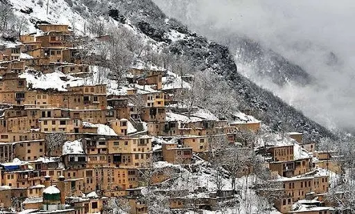
Masuleh Village (House Roofs Are Used As Streets), Sardar-e Jangal District, Fuman County, Gilan Province, Iran.

Masuleh is a village in the Sardar-e Jangal District, in Fuman County, Gilan Province, Iran. At the 2006 census, its population was 554 individuals from 180 families. Historical names for the city include Māsalar and Khortāb. It was founded in the 10th century AD. Masuleh is approximately 60 km southwest of Rasht and 32 km west of Fuman. The village is 1,050 meters above sea level in the Alborz (or Elburz) mountain range, near the southern coast of the Caspian Sea. The village itself has a difference in elevation of 100 meters.

Although it has been written that the community was established around 10 AD, the province of Gilan has a long history. The first village of Masuleh was established around 1006 AD, 6 km northwest of the current city, and it is called Old-Masuleh (Kohneh Masuleh in Persian). People moved from Old-Masuleh to the current city because of pestilence and attacks from neighbouring communities. Masouheh-Rood-Khan is the river passing through the city, with a waterfall located just 200 meters away from the village. It's cut-off by snow during the winter months. Fog is the predominant weather feature of Masuleh.

Masuleh’s architecture is unique. The buildings have been built into the mountain and are interconnected. Courtyards and roofs both serve as pedestrian areas similar to streets. Masuleh does not allow any motor vehicles to enter, due to its unique layout. It is the only city in Iran with such a prohibition. However, the small streets and many stairs simply wouldn't make it possible for vehicles to enter. The spectacular architecture of Masuleh is popularly known as "The yard of the building above is the roof of the building below".

Yellow clay coats the exterior of most buildings in Masuleh. This allows for better visibility in the fog. Buildings are mostly two stories (1st floor and 'ground' floor) made of adobe, rods and bole. A small living room, big guest room, winter room, hall, WC and balcony are usually found in 1st floor. A cold closet, barn and stable are located on the floor below, which are connected to the upper floor by several narrow steps inside the building. There are four main local communities at the city named: "Maza-var" (meaning beside the Mosque) at the south, "Khana-var" (beside homes) at the East, "Kasha-sar" (stretched on top) at the North, and, "Assa-mahala" (Assad community) at the West. Apparently, down town is the Market (Bazaar) area and also the main mosque of the city, named "O-ne-ben-ne Ali" (Awn Ibn Mohammad Ibn Ali Ibn. Abi Taleb) built in 969 AD.


Due to avoiding utilization of human figures and abstaining from idolatry, decorations have specific geometry in Islamic art and architecture. One of the striking characteristics of the knots (girih) that has caused to dynamicity throughout its thousand-year history is its regeneration and diversification of the diverse geometric properties. Girih tiling decoration is part of geometric arts in the traditional buildings of the historic town of Masouleh dates back to eight hundred years. Traditional and local architects of this historical town have adopted special and intellectual plans for creating visual attractions in expression and creation of girih tiling in the walls of the monuments. One of these valuable solutions is diverse geometric decorations patterns .Since the main facades of the houses in this town are directly located in the sunrise direction and it is accepted landscape for the citizens of this historical town, thus the artists have shown their art and style in this part of the monument and built beautiful and harmonic diverse wooden windows and variety of these patterns are seen in all five neighborhoods in this town. Girih tiling consists of straight and broken lines on a regular basis that could be reasonably expanded in the surface. Geometric designs (both normal and abnormal) and purely geometric interlaced patterns involve mental imaginary forms which are essentially superior to the perception- based naturalistic images. The patterns were not aimed to capture the reality perceived through the eyes, but they were supposed to create a glimpse of astonishing beauty in the artist’s creative mind or soul. Due to avoiding utilization of human figures and abstaining from idolatry, decorations have specific geometry in Islamic art and architecture. One of the striking characteristics of the knots (girih) that has caused to dynamicity throughout its thousand-year history is its regeneration and diversification of the diverse geometric properties. Girih tiles are used in Islamic art and architecture. Iranian Chinese Knotting is one of is one of traditional fields and professions that depends on geometrical patterns and on the first encounter, the spectator, is subconsciously affected by its discipline. Geometrical patterns, which are the source for the art Chinese Knotting, usually contain a polygon star in the middle (the Shamseh) and some other geometrical figures so that they can cover the remaining space. Chinese knotting is not specifically a certain decoration or a means of conveying the emotions of the artist, but also the point of making them regarding to two ways: acting on the basis of their own knowledge and guiding others towards this knowledge. When a spectator looks upon the works of Chinese Knotting, they’re first affected by its beauty and especially its discipline, but after some more contemplation they are driven into the art’s mystical meanings. Girih tile is a part of Islamic architecture and art while its different types are used in the following arts: Wood carving, tiling, plaster, Khātam, brick work, mirror work, stone work and in carpentry as fences, door and window, wooden decorations and wood carving of Minbar and in blacksmith Iranian architecture. Girih tile is an intelligent interaction of aesthetics and function. Islamic artists have applied local materials in accordance to the functional requirements and cultural issues of each region. The valuable examples of this art are observed in historical city of Masoule located in the mountainous area of Masoule in Gilan (Iran). Wood is one of the highly applied materials in traditional architecture of Gilan with its different types. One of the greatest arts is seen in the historical city of Masoule with Girih tiles. Wood is used in this region due to its climatic condition and the need to a good thermal isolation against heat and cold weather. Also, wood is the first material being applied in openings. Girih tiles decorations in this historical city are abundant in the buildings while their main façade is to the south. One of the advantages of using Girih tiles in openings of this historical city is to control the direct light in different seasons of year. The aesthetic aspect is on the second priority. The beauty of Girih tiles, their coordination and part to total tendency in all openings have improved the unity and beauty of the historical buildings of Masoule. Sash window, other meshes and Telar with combination of decorative plants in the façade of buildings in Masoule have increased the aesthetics of this city. Historical city of Masoule is a good model for sustainable architecture and its final aim is respecting the culture and friendly relationship with nature and improving the life style of its residents.


Their are many other places to visits at Masuleh -

  • Museum of Anthropology Masuleh: Established in 2002 and incorporates the history of Masuleh and its people. 
  • Forest park: Masouleh Forest Park is one of the most beautiful forest parks in northern Iran and even in the Middle East. The variety of plants in this park is very large and trees like rush, alder, hornbeam, hazelnut, as well as herbs are seen in it. 
  • Waterfalls kooshm and larcheshme and kourbar.

Masuleh also has its own beauties in winter and tourists can enjoy its beauties in this season as well.

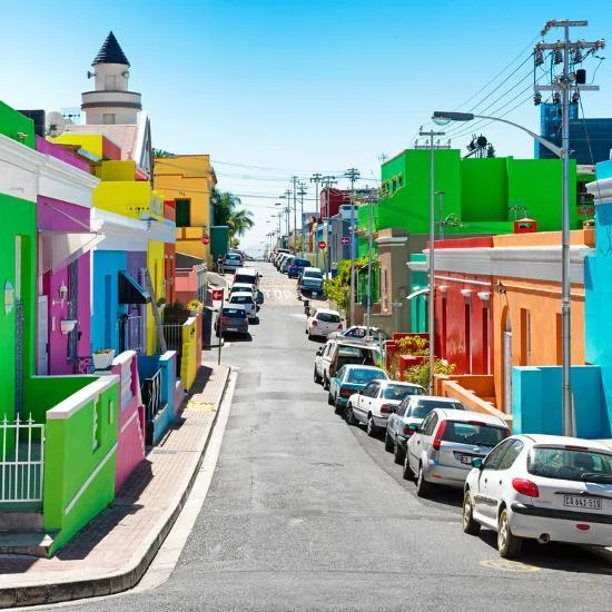
The Bo-Kaap, Cape Town, South Africa

The Bo-Kaap is an area of Cape Town, South Africa formerly known as the Malay Quarter. It is a former racially segregated area, situated on the slopes of Signal Hill above the city centre and is a historical centre of Cape Malay culture in Cape Town. The Nurul Islam Mosque, established in 1844, is located in the area.

Bo-Kaap is known for its brightly coloured homes and cobble stoned streets. The area is traditionally a multicultural neighbourhood, and 56.9% of its population identify as Muslim. According to the South African Heritage Resources Agency, the area contains the largest concentration of pre-1850 architecture in South Africa, and is the oldest surviving residential neighborhood in Cape Town.

In 1760 Jan de Waal bought a block of land at the foot of Signal Hill, between Dorp and Wale Streets. A year later he obtained an adjacent parcel, extending his holding to Rose/Chiappini/Shortmarket Street. Starting in 1763, de Waal built several small “huurhuisjes” (rental houses) on this land, which he leased to his slaves. The first three are at 71 Wale Street (now the Bokaap Museum), above Buitengracht Street, and 42 Leeuwen Street respectively.

Skilled Muslim labourers called Mardijkers moved to the Cape from Southeast Asia and lived in the Bo-Kaap Because the aboriginal tribes in the (Cape Town) area resisted the Dutch, slaves were initially imported from Malaysia, Indonesia and other parts of Africa, hence the name “Malay”. Most of the new residents were Muslim, and several mosques were built in the area. The first one was Auwal Mosque, in Dorp Street in 1794. Between 1790 and 1825 more housing in both the Cape Dutch and Cape Georgian styles was built for the expanding population of tradesmen, craftsmen, and artisans. More Muslims continued to move into the area, including a wave of political exiles from Java and Ceylon circa 1820.After the emancipation in 1834 and the arrival of liberated slaves, developers constructed numerous rows of narrow, deep huurhuisjes. 


The brightly coloured facades are attributed to an expression of freedom by the new homeowners, as all the houses were painted white while on lease, although it appears that the tradition of brightly coloured homes appeared at some point in the late 20th century, rather than earlier. Although the area has always been a centre of Cape Malay culture, until the implementation of the Apartheid Group Areas Act, it also had residents of other ethnicities. These included Indians, non-Muslim Coloureds, Filipinos, Africans, Portuguese and Italians at different times. Historically, the Bo-Kaap was larger than its current extent.

During Apartheid, the area was not bulldozed, unlike nearby District Six, however non-Malay residents were forcibly removed in accordance with the Group Areas Act, in an effort by a sympathetic apartheid government official (I. D. du Plessis) to preserve the Malay character of the area. Preservation of the area began in 1943 when 15 houses were restored by a group of prominent citizens, with the support of the Historical Monuments Commission. In 1966 a portion of the area was designated as a National Monument. From 1971 the City Council began restoring houses and streetscapes, with 48 units completed by 1975.

As a result of Cape Town's economic development and expansion, and after the demise of forced racial segregation under apartheid, property in the Bo-Kaap has become very sought after, not only for its location but also for its picturesque cobble-streets and unique architecture. Increasingly, this close-knit community is "facing a slow dissolution of its distinctive character as wealthy outsiders move into the suburb to snap up homes in the City Bowl at cut-rate prices". Inter-community conflict has also arisen as some residents object to the sale of buildings and the resultant eviction of long-term residents.


In May 2019, 19 sites in the Bo-Kaap area were declared National Heritage Sites by the South African Minister of Arts and Culture. The announcement followed  the City of Cape Town's council's March 2019 approving of the inclusion of the Bo-Kaap area in a Heritage Protection Overlay Zone (HPOZ), which will incorporate around 600  privately-owned homes. The City received over 2,000 letters from members of the public, a strong majority of which were in support of the new Heritage Zone. The HPOZ stretches to the Table Mountain National Park, and includes the northern verges to the northwest of Strand Street as well as Buitengracht Street, between the intersections with Carisbrook Street and Strand Street.

The 19 sites became official National Heritage Sites through a declaration by the South African Heritage Resources Agency, under the National Heritage Resources Act (No 25 of 1999). Objectives of the Heritage Zone include conserving the Bo-Kaap heritage by encouraging owners to retain and rehabilitate the existing residential buildings; ensuring new developments in the area complement existing landscape; and promoting social and cultural traditions in the area.

The museum, whose building dates back to the 1760s, is the oldest house in the area still in its original form. It highlights the cultural contribution made by early Muslim settlers, many of whom were skilled tailors, carpenters, shoe makers and builders. It contains 19th century furnishings which include a fine Cape drop-leaf dining table, Cape Regency-style chairs and a bridal chamber decorated to match the bride's dress. The museum is distinguishable by its voorstoep, a type of front terrace with a bench at each end emphasizing the polarizing aspect of Cape Muslim culture. The museum exhibits the lifestyle of a prosperous 19th-century Cape Muslim family along with black-and-white photographs of daily life in the area.