May 6, 2020

Reynisfjara's Black Sand Beach, Iceland

Reynisdrangar are basaltsea stacks situated under the mountain Reynisfjall near the village Vík í Mýrdal, southern Iceland which is framed by a black sand beach that was ranked in 1991 as one of the ten most beautiful non-tropical beaches in the world.

Legend says that the stacks originated when two trolls dragged a three-masted ship to land unsuccessfully and when daylight broke they became needles of rock. Contemporary legends note the story of a husband who found his wife taken by the two trolls, frozen at night. The husband made the two trolls swear to never kill anyone ever again. His wife was the love of his life, whose free spirit he was unable to provide a home for; she found her fate out among the trolls, rocks, and sea at Reynisfjara.


Reynisfjara black volcano beach on Iceland’s South Coast is one of the most unique black sand beaches in the world. It’s not a tanning kind of beach. More look than touch, it was created by lava flowing into the ocean which cooled almost instantly as it touched the water. The black sand isn’t the only lava creation on Reynisfjara. Opposite of the sea is an enormous natural pyramid made of basalt columns that looks like a staircase to the sky. This basalt cliff is called Gardar. The symmetrical columns were shaped when, once upon a time, lava flowed out, cooled and contracted. The slow speed at which the lava cooled made it crack and create these hexagonal forms. This process is known as columnar jointing.
 
Their are lot of  other point of attraction in  Iceland where you can enjoy real beauty of black sand and nature. 

May 4, 2020

Old Tjikko (Oldest Living Tree In World), Fulufjället Mountain, Dalarna Province, Sweden

Old Tjikko is a 9,550 year-old Norway Spruce, located on Fulufjället Mountain of Dalarna province in Sweden. Old Tjikko originally gained fame as the "world's oldest tree." Old Tjikko is, however, a clonal tree that has regenerated new trunks, branches and roots over millennia rather than an individual tree of great age. Old Tjikko is recognized as the oldest living Picea abies and the third oldest known clonal tree.

The age of the tree was determined by carbon dating of genetically matched plant material collected from under the tree, as dendrochronology would cause damage. The trunk itself is estimated to be only a few hundred years old, but the plant has survived for much longer due to a process known as layering (when a branch comes in contact with the ground, it sprouts a new root), or vegetative cloning.


The root system of Old Tjikko is estimated to be 9,562 years old, making it the world's oldest known Norway spruce. It stands 5 metres (16 ft) tall and is located on Fulufjället Mountain of Dalarna province in Sweden. For thousands of years, the tree appeared in a stunted shrub formation (also known as a krummholz formation) due to the harsh extremes of the environment in which it lives. During the warming of the 20th century, the tree sprouted into a normal tree formation. The man who discovered the tree, Leif Kullman (Professor of Physical Geography at Umeå University), attributed this growth spurt to global warming and gave the tree its nickname "Old Tjikko" after his late dog.

The tree has survived for so long due to vegetative cloning. The visible tree is relatively young, but it is part of an older root system that dates back thousands of years. The trunk of the tree may die and regrow multiple times, but the tree's root system remains intact and in turn sprouts another trunk. The trunk may only live for about 600 years, and when one trunk dies another eventually grows back in its place. Also, each winter, heavy snow may push the tree's low-lying branches to ground level, where they take root and survive to grow again the next year in a process known as layering. Layering occurs when a tree's branch comes in contact with the earth, and new roots sprout from the contact point. Other trees, such as coast redwoods and western redcedars are known to reproduce by layering. The tree's age was determined by carbon-14 dating of the root system, which found roots dating back to 375, 5,660, 9,000, and 9,550 years. Carbon dating is not accurate enough to pin down the exact year the tree sprouted from seed; but, given the estimated age, the tree is supposed to have sprouted around 7550 BC. For comparison, the invention of writing (and thus, the beginning of recorded history) did not occur until around 4000 BC. Researchers have found a cluster of around 20 spruce trees in the same area, all over 8,000 years old.

The estimated age of Old Tjikko is close to what would be possible for this area, as the last ice age's receding Fenno-Scandian ice sheet only released the Fulufjället Mountain around 10,000 years ago. Nature conservancy authorities considered putting a fence around the tree to protect it from possible vandals or trophy hunters.

May 3, 2020

Seven Mile Bridge, Florida Keys, Monroe County, Florida, United States.

The Seven Mile Bridge is a bridge in the Florida Keys, in Monroe County, Florida, United States. It connects Knight's Key (part of the city of Marathon, Florida) in the Middle Keys to Little Duck Key in the Lower Keys. Among the longest bridges in existence when it was built, it is part of the Overseas Highway in the Keys, which is part of the 2,369-mile (3,813 km) U.S. Route 1

There are two bridges in this location. The modern bridge is open to vehicular traffic; the older one only to pedestrians and cyclists. The older bridge, originally known as the Knights Key-Pigeon Key-Moser Channel-Pacet Channel Bridge, was constructed from 1909 to 1912 under the direction of Henry Flagler and Clarence S. Coe as part of the Florida East Coast Railway's Key West Extension, also known as the Overseas Railroad. 


After the railroad was damaged by the Labor Day Hurricane of 1935, the line was sold to the United States government, which refurbished Seven Mile Bridge for automobile use. Unsupported sections were added in 1935 to widen it for vehicular traffic. Dismantled trackage was recycled, painted white, and used as guardrails. It had a swing span to allow passage of boats in the Moser Channel of the Intracoastal Waterway, near where the bridge crosses Pigeon Key, a small island that held a work camp for Flagler's railroad. Hurricane Donna in 1960 caused further damage. The current road bridge was constructed from 1978 to 1982.

The vast majority of the original bridge still exists, although the swing span has been removed. The 2.2-mile section to Pigeon Key, used as a fishing pier and long open to motorized vehicles to give access to the key, was closed to motorized traffic in 2008 after the unsupported sections began to sag. In 2014, the Florida Department of Transportation approved a $77 million plan to restore the old bridge. By 2017 the pedestrian section was closed, with extensive repairs predicted to be finished by about late 2021.

The new bridge is a box-girder structure built from precast, prestressed concrete sections, comprising 440 spans. Near the center, the bridge rises in an arc to provide 65-foot (20 m)-high clearance for boat passage. The remainder of the bridge is considerably closer to the water surface. The new bridge does not cross Pigeon Key. The total length of the new bridge is actually 35,862 ft (10,931 m) or 6.79 miles (10.93 km), and is shorter than the original. The bridge carries the Florida Keys aqueduct, supplying water to points west, as well as fiber optic cables, providing telecommunications to and from the lower Keys.

Each April, the bridge is closed for about 2.5 hours on a Saturday for the Seven Mile Bridge Run that commemorates the Florida Keys bridge rebuilding project. The event began in 1982 to commemorate the completion of a federally funded bridge building program that replaced spans that oil tycoon Henry Flagler constructed in the early 1900s to serve as a foundation for his Overseas Railroad.

The Seven Mile Bridge was engineered by Figg & Muller Engineers (who also engineered the much taller Sunshine Skyway Bridge). The structure was completed six months ahead of schedule and has earned eight awards, including an Exceptional Award for Cost Savings Innovation from the Federal Highway Administration.

May 2, 2020

Gomukh (Mouth Of Cow), Uttarkashi District, Uttarakhand, India

Gomukh, also known as "Gaumukh" or "Gomukhi" , is the terminus or pout of the Gangotri Glacier and the source of the Bhagirathi River, one of the primary headstreams of the Ganges River. The place is situated at a height of 13,200 ft (4,023 m) in Uttarkashi district in the state of Uttarakhand, India. It is one of the largest in the Himalayas with an estimated volume of over 27 cubic kilometers. It is a holy Hindu pilgrimage site, along with Gangotri, as well as trekking destination. On 26 July 2016, following heavy rains in Uttarakhand, it was reported that the front end of Gomukh was no more, as a large chunk of the glacier had collapsed and was washed away. In 2013, due to cloud burst in Uttarakhand, huge cracks had emerged on the glacier.

The word "Gomukh/Gaumukh" (go/gau=cow, mukh= mouth) literally means "Mouth of a Cow." Before the heavy rains in year 2016, the opening of the cave looked exactly like the "Mouth of a Cow." In 1972,Sir Seewoosagur Ramgoolam the then Prime Minister of Mauritius,brought the holy Ganga water from Gomukh and mixed it with the water of Grand Bassin in Mauritius and renamed it as Ganga Talao for the Mauritian Hindus.


Gomukh is mentioned in the Puranas. It is said there that , searching a lost sheep , a boy reached near a glacier in Gangotri, the snout of which exactly looked like the mouth of a cow, and thus it got its name 'Gomukh' . From then many holy saints , sages , sadhus , hermits , adventure seekers, as well as religious people and adventure seekers also went there to worship the place. It is also rumored that , if anyone visits Gomukh / Gawmukh with evil intentions or polluted body or mind , his ancestors fall in Burning Hell and that person experiences grave horrors and deep melancholy surrounds him.

Gomukh is 18 km from Gangotri in the foot hills of Bhagirathi at a height of 4255m. It is the snout of the Gangotri Glacier. The Bhagirathi river here is pretty speedy. Around the snout, nature presents a wild topography. There are boulders scattered here and there with some pieces of broken snow, along with the hard clayey snow of the glacier. The Gomukh snout is rapidly moving backwards. According to the modern research the snout has moved 1 km in just 70 years.

The first and foremost thing for Gomukh trek is that you must have permission from (D.F.O.) District forest officer, Uttarkashi. Only 150 permits are issued per day, permission can be taken via fax also. The trail to Gomukh begins from Gangotri, about 18 km (11.2 mi) from Gomukh. It was heavily damaged by rockslides by the 2013 North Indian Floods as was road access to Gangotri. 9 km ahead of Gangotri is Chirbasa, the abode of Chir trees. After 3 km of Chirbasa comes the dangerous Gila Pahar, the place well known for its landslides even prior to the 2013 destruction of much of the trail here; near-sheer cliffs down to the river must now be traversed. Here the Bharals, a type of mountain antelope are sometimes seen. The Bharals are found above the altitude of 10,000 ft. Only 4 km from here is Bhujbasa, the only night halting place on the way with buildings. One can stay at the GMVN Bunglow, or at the Lalbaba's Ashram or at Ram Baba's ashram; both ashram charge Rs 350 for a day that includes lodging and food. After trekking 41/2km from Bhujbasa, one reaches Gomukh, the snout of the Gangotri Glacier.A little before Gomukh, the majestic view of Mt. Shivling welcomes the trekkers to the place. On the trail no horses are allowed, so one must take preparations to walk on foot. The trek to Tapovan and Nandanvan starts from here.

The route after 'Bhojbasa' can be quite difficult, more so since the 2013 floods. One has to cross a boulder zone to reach the Gomukh snout. The trek beyond Gomukh is quite difficult. Crossing the glacier & going towards Tapovan has become quite dangerous nowadays (because of the landslides). There is no track and one must have a guide and should be prepared to face any type of accident which can even be a life-threatening one. The last climb to reach Tapovan is very stiff, within 2 km a climb of around 1500 foot and is quite a challenging experience.

You may apply for an online permit. , even with an online permit you would still need to get it verified at the district magistrate uttrakasi office.
 

Apr 30, 2020

Eshima Ohashi Bridge (Most Amazing Bridge In World), Western Chugoku, Japan

Eshima Ohashi Bridge is a rigid-frame bridge in Japan that connects Matsue, Shimane Prefecture and Sakaiminato, Tottori Prefecture over Nakaumi lake. It was built from 1997 to 2004. It is the largest rigid-frame bridge in Japan and the third largest in the world. Images of the bridge have been widely circulated on the internet, owing to its seemingly steep nature when photographed from a distance with a telephoto lens, but in actuality the Shimane side has a gradient of 6.1% and Tottori side of 5.1%.
 
Eshima Ohashi Bridge replaced the previous drawbridge. Traffic was obstructed often by ships for about 7 to 8 minutes. Also large vehicles over 14 tons were not allowed on the drawbridge. The drawbridge saw 4,000 vehicles a day cross. 


Eshima Ohashi Bridge has become a modest tourist attraction in its own right. The bridge spans 1.7 kilometers over Lake Nakaumi, between Sakaiminato in Tottori Prefecture and Eshima in Shimane Prefecture. Seen from the Shimane side, the bridge looks impossibly steep. However, in reality, the bridge has a gradient of 6.1% on the Shimane side and 5.1% on the Tottori side. The bridge is the largest rigid-frame bridge in Japan and the third largest in the world. It is often referred to as the world's “craziest” or “scariest” bridge.

Large ships pass under the bridge which necessitated its 45-meter height; the slope angle on the Shimane Prefecture Matsue City side is 3.5 degree and the Tottori Prefecture Sakaiminato City side slopes at a 2.9 degree angle. If you’re taking a picture, in order to see the bridge’s famous “sloping up into the sky” effect, it’s recommended you take pictures from the Matsue City side.

The Eshima Ohashi Bridge is also known as “Betabumizaka.” This essentially means “Pedal-to-the-floor Hill” the reason for this name is that unless you push your car’s accelerator pedal all the way down you won’t be able to continue driving up the steep bridge incline. Of course you can also walk up the bridge, and in fact if you’re driving you won’t be able to enjoy the beautiful views at the top of the bridge like you would if you were walking. The bridge’s night scenery is similarly beautiful. 

Tarkhan Dress (World’s Oldest Dress), University College London Petrie Museum of Egyptian Archaeology, London

The Tarkhan Dress, named for the Tarkhan cemetery south of Cairo in Egypt where it was excavated in 1913, is an over 5000 years old linen garment that was confirmed as the world's oldest piece of women clothing. The dress coded UC28614B is currently in the collection of the University College London (UCL) Petrie Museum of Egyptian Archaeology. Radiocarbon testing conducted in 2015 by the University of Oxford affirms, with 95% accuracy, that the dress dates from between 3482 and 3102 BCE.

Researchers have confirmed that a 5,000-year-old linen shirt is the world's oldest known woven garment ever found. The dress was excavated at Tarkhan, an ancient Egyptian cemetery dating back to about 3,000 B.C. In 1913, the shirt, which became known as the Tarkhan dress, lay among a pile of textiles recovered from Egypt's First Dynasty cemetery located 50 kilometers south of Cairo. It was discovered only in 1977, among the filthy bundle of cloth pieces during conservation and cleaning work by the Victoria and Albert Museum in London. The cloth piece was carefully conserved, stitched onto Crepeline (a fine silk material used in textile conservation), and mounted so it could be seen the way it was worn in life.


The Tarkhan dress was sent to the Petrie Museum of Egyptian Archaeology at University College London in the early 1990s after being found in an Egyptian tomb. The linen garment, with V-neck, pleated sleeves and bodice, is understood to be made by a specialized craftsman for a wealthy person.

Alice Stevenson, the museum’s curator, said: “The early date of the Tarkha dress is unsurprising. “Textile fragments made of flax are known from at least Egyptian Neolithic times, while weaving on horizontal looms is evidenced from at least the early fourth millennium.”

Ms Stevenson said that linen garments, like the Tarkhan, are particularly good to radiocarbon date as they consist of flax fibres that grow over a relatively short time.

Apr 28, 2020

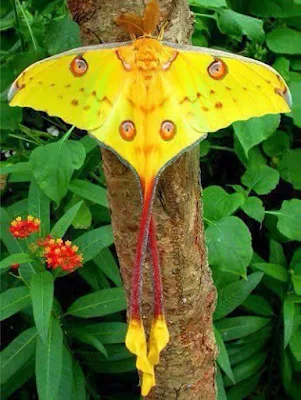
The Luna Moth (One Of The Largest Moths In World), North America, United States

The Luna moth (Actias luna) is a Nearcticmoth in the family Saturniidae, subfamily Saturniinae, a group commonly known as giant silk moths. It has lime-green colored wings and a white body. The larvae (caterpillars) are also green. Typically, it has a wingspan of roughly 114 mm (4.5 in), but can exceed 178 mm (7.0 in), making it one of the larger moths in North America. Across Canada, it has one generation per year, with the winged adults appearing in late May or early June, whereas farther south it will have two or even three generations per year, the first appearance as early as March in southern parts of the United States. As defense mechanisms, larvae emit clicks as a warning and also regurgitate intestinal contents, confirmed as having a deterrent effect on a variety of predators. The elongated tails of the hindwings are thought to confuse the echolocation detection used by predatory bats. A parasitic fly deliberately introduced to North America to be a biological control for the invasive species gypsy moth appears to have had a negative impact on Luna moths and other native moths.


Eggs, attached in small groups to undersides of leaves, are mottled white and brown, slightly oval, and roughly 1.5 millimeters in diameter. Larvae are primarily green, with sparse hairs. The first instar, emerging from the egg, reaches a length of 6–8 mm (0.24–0.31 in), the second 9–10 mm (0.35–0.39 in), the third 12–16 mm (0.47–0.63 in) and the fourth 23–26 mm (0.91–1.02 in). The fifth (final) instar grows to approximately 70–90 mm (2.8–3.5 in) in length. Small, colorful dots – yellow or magenta – may line the sides of the fourth and fifth instars. The larvae may take on a reddish-brown color just prior to cocooning. Fifth-instar larvae descend to the ground and use silk to bind dead leaves around the cocoon.

The imagoes (winged, sexually mature), often referred to as 'adult moths,' emerge from the pupae with the wings small, crumpled and held close to the body. Over a period of several hours the wings will enlarge to full size. Wingspan is typically 8–11.5 cm (3.1–4.5 in), and in rare instances as much as 17.78 cm (7.00 in). Females and males are similar in size and appearance: green wings, eyespots on both forewings and hind wings, and long, sometimes somewhat twisted tails extending from the back edge of the hindwings. Bodies are white and hairy. Adults have vestigial mouthparts and do not feed. Energy is from fat stores created while a caterpillar. The forward edge of the forewing is dark-colored and thick, tapering in thickness from the thorax to the wing tip. Its color can range from maroon to brown. The eyespots, one per wing, are oval in shape on the forewings and round on the hindwings. Each eyespot can have arcs of black, blue, red, yellow, green or white. The eyespots are thought to confuse potential predators. There are some sex-determined and regional differences in appearance. Females will have a larger abdomen compared to males because it contains 200–400 eggs. Both sexes have antennae, but on the male, much longer and wider. Wing color is blue-green in the north and for the over-wintering generation in the central and southern states; second and third generation wing color has more of a yellow-green tint.

Described and named Phalena plumata caudata by James Petiver in 1700, this was the first North American saturniid to be reported in the insect literature. The initial Latin name, which roughly translates to "brilliant, feather tail", was replaced when Carl Linnaeus described the species in 1758 in the tenth edition of Systema Naturae, and renamed it Phalaena luna, later Actias luna, with luna derived from Luna, the Roman moon goddess. The common name became "Luna moth". Several other North American giant silk moths were also given species names after Roman or Greek mytholog. The Luna moth is found in North America, from east of the Great Plains in the United States – Florida to Maine, and from Saskatchewan eastward through central Quebec to Nova Scotia in Canada. Luna moths are also rarely found in Western Europe as vagrant.
 
For More Information- Luna Moth

Apr 27, 2020

The Bailong Elevator ( Highest Outdoor Elevator In The world), Zhangjiajie, China

The Bailong Elevator is a glass elevator built onto the side of a huge cliff in the Wulingyuan area of Zhangjiajie, People's Republic of China that is 326 m (1,070 ft) high. It is claimed to be the highest and heaviest outdoor elevator in the world. Construction of the elevator began in October 1999, and it was opened to the public by 2002. The environmental effects of the elevator have been a subject of debate and controversy, as the Wulingyan area was designated a World Heritage Site in 2002. Operations were stopped for 10 months in 2002–2003, reportedly due to safety concerns, not environmental ones. On 16 July 2015, the elevator was officially recognized by Guinness World Records as the world's tallest outdoor lift.
 
The name Bailong means A Hundred Dragons in English. Therefore, Bailong Elevator is also known as Hundred Dragons Elevator. The elevator is located in the World Heritage site Wulingyuan Scenic Area. It took a mere three years to build this architectural marvel! When the proposal of creating such an elevator appeared, the engineers just wanted to help tourists enjoying the scenery in ease and convenient. With the discussion went on, more and more environmental ideas were added. Considering not to upset the natural balance of the neighborhood, half of the elevator was embedded in and half out of the cliff. In order to perfectly “hidden” in the surroundings, all of the elevators were fitted with glass windows. And finally, such a special elevator created. 


Usually, hiking from the bottom of Yuanjiajie to its top needs about 2 hours so, Bailong Elevator is an attraction itself. Besides, it is also a time-saving way for you to get up or down the hill. Bailong Elevator is very magnificent. The total height of it is 335 meters (1099 feet), of which the running height is 326 meters (1069 feet). 154 meters (505 feet) of the total height is in the mountain wells and the rest of 172 meters (564 feet) was composed of steel derrick and other components. The Elevator includes three exposure sightseeing elevators running parallelly. Each elevator can take 64 passengers every time and the speed is 3 m / s (the speed has been accelerated to 5m / s since 2013). If the three elevators run simultaneously, the amount of one-way passengers will reach 4,000 per hour.

The construction of Bailong Elevator can allow people to “go sightseeing up the mountain during the day, stay down the mountain at night in one day". So it provides convenience in transportation for visitors. Moreover, passengers can appreciate peerless scenery in the elevator, including World Bridge of Yuanjiajie, Wulong village and Yangjiajie etc. The elevator integrates Mount Tianzi, Yuanjiajie, Jinbian Stream as a single entity, solving traffic bottlenecks problem in this scenic spot which bothers the visitors for many years.