Apr 24, 2020

Ice Eggs (Mysterious Of Eggs), Hailuoto Island, Finland

Ice Eggs is a rare weather phenomenon. Thousands of egg-shaped balls of ice have covered a beach in Finland. Experts say it is caused by a rare process in which small pieces of ice are rolled over by wind and water. The "ice eggs" littered an area the length of about one-quarter of a football field and ranged in size from that of an average chicken egg to that of a hefty soccer ball.


Autumn is the perfect time to see the phenomenon, according to Dr James Carter, emeritus professor of geography-geology at Illinois State University, as this is when ice starts to form on the surface of water, creating a form of slush when moved by waves. The core begins to collect ice around it and the swell moves it along the beach, forward and back. A small ball surface gets wet, freezes and becomes bigger and bigger.”

Apr 23, 2020

Coron Island, Palawan in the Philippines.

Coron Island is the third-largest island in the Calamian Islands in northern Palawan in the Philippines. The island is part of the larger municipality of the same name. It is about 170 nautical miles (310 km) southwest of Manila and is known for several Japaneseshipwrecks of World War II vintage. Because of its unique ecological features, the entire area is protected by several legal proclamations.

The island and surrounding fishing grounds are part of the ancestral domain of the indigenous Tagbanwa people, officially designated such on June 5, 1998. Known as Calis among the Tagbanwas and Coronians, its tribal chieftain is Rodolfo Aguilar I. The island comprises two barangays of the municipality of Coron: Banuang Daan and Cabugao.


Partially between Busuanga and Culion islands, Coron Island faces the Sulu Sea and forms the eastern side of Coron Bay. It is about 20 kilometres (12 mi) long from north to south, and 9 kilometres (5.6 mi) at its widest point. It is a wedge-shaped mountainous island, dominated by steep cliffs and Karst rock formations made of Permianlimestone of Jurassic origin that comprises about 70% of its area. Another 25% is rolling hills, while only 5% is relatively flat. There are 11 lakes nestled in the rugged terrain, of which 3 have underground connections to the sea. There are a few mangroves in coastal areas.

The area around the wrecks has rock formations which provide for snorkeling opportunities, with underwater visibility extending up to 80 feet (24 m). The water is often calm. Coron is one of the most visited destinations for wreck diving in the Philippines. Wreck dive sites are found in depths as shallow as 10–30 feet (3.0–9.1 m) and as deep as 120–140 feet (37–43 m). Most are in the range of about 60–80 feet (18–24 m). Dive sites around Coron include many different reef dive sites and "Günter´s Cave", also known as Cathedral Cave because during a certain time of the day, the sun throws a beam of light through a hole in the cave ceiling, illuminating the inside. It is possible to surface in the cave, as the hole in the cave-ceiling allows fresh air to enter. The cave is named after Günther Bernert, who was part of the first dive group to explore the cave, after hearing from local fishermen about its existence.

Wreck diving sites in Coron Bay include the Akitsushima, Irako, Kogyo Maru, Kyokuzan Maru, Nanshin Maru, Okikawa Maru, Olympia Maru, Lusong Gunboat, East Tangat gunboat (the name of the ship, Terukaze Maru, was recently discovered by a group of Dutch divers, who spent a couple of days digging into bottom sand around the stern), and 'Skeleton' Wrecks. The aquatic views from the sunken Japanese ships off Coron Island are listed in Forbes Traveler Magazine’s top-10 best scuba diving sites in the world. Ecotourism has long surpassed diving as the top draw to Coron island in the last decade. With domestic tourism on the rise due to a rapidly growing middle class, Coron is one of the top destinations for Filipinos to add to their wish list, with Coron island containing some of the most iconic.

Crowley Lake ( The Strange Columnar Formations), Mono County, California, United States

Crowley Lake is a reservoir on the upper Owens River in southern Mono County, California, in the United States. Crowley Lake is 15 miles south of Mammoth Lakes.

The lake was created in 1941 by the building of the Long Valley Dam by the Los Angeles Department of Water and Power (DWP), as storage for the Los Angeles Aqueduct and for flood control. The dam is 126 feet high and impounds 183,465 acre-feet. For more on the history of the lake, see Owens Lake.

It is known for its trout fishing: Between 6,000 and 10,000 anglers hit the lake on opening day. The largest brown trout taken from the lake weighed 26 pounds. Many people from all over California head here for late summer and fall fly fishing since the lake contains some of the largest trout around. Crowley Lake Fish Camp, run in cooperation with the Los Angeles Department of Water and Power, is the only way to access the lake, and visitors can rent boats, book camping sites, and buy supplies at the Fish Camp.



The lake is named after Father John J. Crowley, “the desert Padre”, who was a key figure in Owens Valley history and a local hero. When it became obvious that the city of Los Angeles’s appropriation of the water supply had made agriculture impossible in the Owens Valley, many of the residents of the Valley lost all hope. Father Crowley traveled up and down the Valley, convincing many of them that it could become a tourist destination. Thus, it is fitting that while it exists to serve the Los Angeles aqueduct, Crowley Lake is also a prime destination for anglers. Father Crowley was killed in 1940 in an automobile accident. 

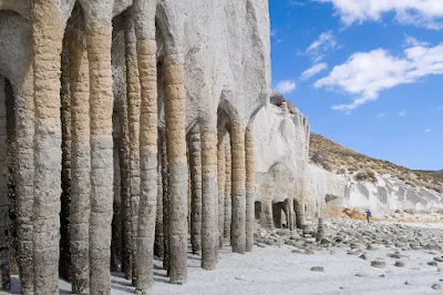
Upon completion of the reservoir in 1941, strange columnar formations, some of which reached heights of as much as 20 feet, were spotted along the reservoir's eastern shore. Some described them as stone cylinders connected by fortified stone arches that had been completely covered and obscured for millions of years but which had been gradually unmasked by the incessant pummeling of the lake's powerful waves, whose constant pounding had eroded the more malleable rock at the base of the cliffs encasing these pillars. The pillars were simply regarded as oddities until 2015, when geologists realized that they were the result of frigid water from melting snow seeping down into volcanic ash (the result of a catastrophic explosion more than 700,000 years prior), creating tiny holes in the hot ash, the byproduct being boiling water and steam, which then rose up and out of these same holes. Samples of the resulting "evenly spaced convection cells similar to heat pipes" (a quote from a study at UC Berkeley) were analyzed using X-rays and electronic microscopes; and researchers found that minute crevices in these "convection pipes" were literally bonded into place by minerals that were able to resist the corrosive force of the lake's waves. Researchers have now counted nearly 5,000 of these pillars, which appear in groups and vary widely in shape, size and color over an area of 4000 acres, with some of the columns standing as erect as towering pylons and sporting ringed apertures approximately a foot apart; others which are warped or leaning at various angles; and still others that are half-submerged and, some say, resemble the petrified remains of dinosaur vertebrae.

Apr 22, 2020

Kakslauttanen Arctic Resort, Saariselkä, Finland

Kakslauttanen Arctic Resort Oy is a holiday village in Sodiselylä's Saariselkä, known for its glass igloos. Glass igloos are hotel rooms or holiday cottages with a domed glass roof, partly excavated underground, which are very suitable for watching the northern lights in winter.

Kakslauttanen was founded by entrepreneur Jussi Eiramo in 1973 as a peat-roofed roadside café. The first glass igloo was built in 2001. Now, in addition to glass igloos, there are log cabins, combinations of log cabin and glass igloo, and a restaurant in the area. In winter, temporary snow igloos are also built in the area. Double-hull turnover has grown rapidly, from € 3.6 million in 2012 to € 13.3 million in 2016.
 
The resort, open year-round except for May, occupies two sites some 155 miles (250km) north of the Arctic Circle on either side of the main northbound Lapland highway to the North Cape, so spectacular and extreme winters are practically guaranteed. Most visitors arrive by flights to Ivalo airport a 30-minute drive away. In the short snow-free summer and colourful autumn, trekkers head for the trails across the upland fells of the adjacent Urho Kekkonen National Park. The Saariselkä resort town is a 15-minute drive from the original East Village.


Glass igloos have received a lot of attention in international travel circles and in the media. Guests can enjoy the snug self-sufficiency of their comfortable cabins, the larger versions of which have kitchenettes, on longer visits (igloo occupancy is rarely for more than a night at a time). Facilities are dispersed and it’s a 10-minute stroll or push-sled trip to the restaurant from some of the farthest-flung cabins in the newer West Village.

Spa and massage services are available and the resort sports the world’s biggest smoke sauna accommodating up to 100 bathers at once. Activities from aurora hunting expeditions on snowmobiles and reindeer or husky sleds to horseback riding, skiing and quad-bike safaris are offered for a fee. Winter clothing and equipment rental is available. Multinational and multilingual staff are helpful and eager.

 For more information - Kakslauttanen Arctic Resort