Aug 28, 2017

Munnar (The Kashmir of South India), Kerala, India

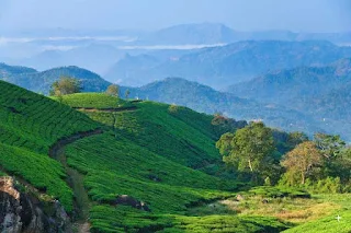
Munnar  is a town and hill station located in the Idukki district of the southwestern Indian state of Kerala. Munnar is situated at around 1,600 metres (5,200 ft) above mean sea level, in the Western Ghats range of mountain. Munnar is an idyllic hill station, famous for its tea estates, exotic scenery, abundance of flora and fauna and craggy peaks.

One of the biggest tea-plantation area of South India, Munnar is one of the most beautiful and popular hill-stations of Kerala. Situated on the
three mountain streams merge - Mudrapuzha, Nallathanni and Kundala. 1,600 m above sea level, this hill station was once the summer resort of the erstwhile British Government in South India blessed with natural view-points apart from the tea-plantations. Munnar is divided into Old Munnar, where the tourist information office is, and Munnar, where the bus station and most guest houses are located. The Eravikulam National Park, Salim Ali Bird Sanctuary and tea plantations are its major attractions.


Sprawling tea plantations, picturesque towns, winding lanes and holiday facilities make this a popular resort town. Among the exotic flora found in the forests and grasslands here is the Neelakurinji. This flower which bathes the hills in blue once in every twelve years, will bloom next in 2018. Munnar also has the highest peak in South India, Anamudi, which towers over 2,695 m. Anamudi is an ideal spot for trekking.

Eravikulam National Park

One of the main attractions near Munnar is the Eravikulam National Park. This park is famous for its endangered inhabitant - the Nilgiri Tahr. Spread over an area of 97 sq. km., this park is also home to several species of rare butterflies, animals and birds. A great place for trekking, the park offers a magnificent view of the tea plantations caressed by blankets of mists. The park becomes a hot destination when the hill slopes here get covered in a carpet of blue, resulting from the flowering of the Neelakurinji. It is a plant endemic to this part of the Western Ghats which blooms once in twelve years.

Anamudi Peak

Located inside the Eravikulam National Park is the Anamudi Peak. This is the highest peak in South India, standing at a height of over 2700 m. Treks to the peak are allowed with permission from the Forest and Wildlife authorities at Eravikulam.

Mattupetty

Another prime draw for visitors, located about 13 km from Munnar Town, is Mattupetty. Situated at a height of 1700 m above sea level, Mattupetty is known for its storage masonry dam and the beautiful lake, which offers pleasurable boat rides, enabling one to enjoy the surrounding hills and landscape. Mattupetty's fame is also attributed to the dairy farm run by the Indo-Swiss Livestock Project, where one can encounter different high yielding breeds of cows.

Pallivasal

Pallivasal, located at about 3 km from Chithirapuram in Munnar is the venue of the first hydro-electric project in Kerala. It is a place of immense scenic beauty and is often favoured by visitors as a picnic spot.

Chinnakanal & Anayirangal

Near Munnar Town lie Chinnakanal and its waterfalls, popularly known as the Power House Waterfalls, which cascade down a steep rock 2000 m above sea level. The spot is enriched with a scenic view of the Western Ghat ranges. When you have traveled about seven kilometers from Chinnakanal, you reach Anayirangal. Anayirangal, 22 km from Munnar, is a lush green carpet of tea plants. A trip on the splendid reservoir is an unforgettable experience. The Anayirangal dam is surrounded by tea plantations and evergreen forests.

Top Station

Top Station, which is about 32 km from Munnar is at a height of 1700 m above sea level. It is the highest point on the Munnar-Kodaikanal road. Travellers to Munnar make it a point to visit Top Station to enjoy the panoramic view it offers of the neighbouring state of Tamil Nadu. It is among the prime spots in Munnar to enjoy the Neelakurinji flowers blooming over a vast area.

Tea Museum

Munnar has a legacy of its own when it comes to the origins and evolution of tea plantations. Taking account of this legacy and to preserve and showcase some of the exquisite and interesting aspects of the genesis and growth of tea plantations in Kerala's high ranges, a museum exclusively for tea was opened some years ago by Tata Tea in Munnar. This Tea Museum houses artifacts, photographs and machinery; all of which have a story to tell about the origins and growth of tea plantations in Munnar. The museum is located at the Nallathanni Estate of Tata Tea in Munnar and is worth a visit.

Jun 24, 2017

Son Bhandar Caves (Cave Of lost Gold), Rajgir, Bihar State, India

Son Bhandar Caves situated at Rajgir, Nalanda in Bihar state. Son bhandar group of caves has two caves known as eastern and western cave. Son bhandar caves are concerned with Jainism and considered to belong to 3-4 century AD. These caves were first inspected by cunninghum and he concluded to have analogy with saptparni caves of Buddhism creed. After cunninghum several scholars visited this place and some had opinion to concern with Buddhism. After some time all Buddhism connections were refused because of an inscription found on the southern wall of a cave. According to this inscription these caves were built by inspiration of a Jain muni Vair for Jain ascetics. Sculptures of Teerthankaras were also carved in these caves. From architectural aspect; these caves are analogous to Nagarjuni cave and Barbar caves of Mauryan era. Therefore it can be concluded that construction time should not be much differ from above mentioned caves. These caves should be related to digambar sect of Jainism as Xuanzang wrote in his book about Vaibhar hill of rajgir that the place was occupied by Digambar Jaina monks for meditation purpose. After some centuries these caves were converted by Hindus as Lord Vishnu sculpture was also found from mound of a cave. 


It is the western cave which gave the name to monument: Son Bhandar means "store of gold" and legend about this treasure is linked to western cave.

The cave believed to be a guard cave – contains single rectangular chamber, 10.4 x 5.2 m large. The vaulted ceiling stands stands on vertical walls, vault rises up to 1.5 m high. This resembles the style of older Mauryan rock-cut sanctuaries. In ancient times most likely there was a roofed verandah in the front of caves.

Walls, doorjambs and front wall contains numerous epigraphs. Small image of standing Vishnu is etched on the left side of doorway this possibly testifies that caves were taken over for Hindu worship. Local legend tells that the this cave still hides a passage to the treasury of gold entrance in this passage is well hidden in the cave chamber behind an ancient stone wedge. Some also believe that the passage goes through Vaibhargiri mountain and reaches Saptaparni Caves on the other side of range. Some believe that this treasure belongs to Jarasandha, others that to Bimbisara. In a case of Bimbisara legend goes that when Ajatashatru confined his father Bimbisara (remnants of this prison are nearby), his mother secretly hid some wealth and later donated it to Tirthankar.

In the wall of cave there is seen a trace of carving, resembling a doorway and next to it – an undeciphered inscription in Sankhlipi writing or shell script. It is believed that this inscription is a password who will read it, will open the door and enter the passage. This ornate script has been found in India as well as in Java and Borneo and never been deciphered. There is also a black mark above or in the upper part of the mysterious doorway is of left by cannonball when Brits tried (without success) to break the wall and enter the passage. 

Eastern cave is partly ruined – front part of cave chamber has fallen. Upper floor above the cliff made in brick is added later, during Gupta period and possibly caused the collapse of front wall of the cave. Most likely also this cave had verandah in front. Southern wall of this cave contains important early Jain artwork – exquisitely sculpted small reliefs of six Jain Tirthankaras – Padmaprabh, Parsvanath, Mahavira and others. This relief seems to be added later, some time after the completion of caves, it shows little congruity with the plan of rock-chamber.

May 9, 2017

A Bird's-Eye View of The Floating Walkway, Luodian County, China

A bird's-eye view of the floating walkway structure built atop the Hongshui River in the Luodian County of southwest China.
 
According to China Xinhua News, a floating walkway which stretches a staggering 31 miles has been built atop the Hongshui River in the Luodian County of southwest China. The new tourist attraction is said to have opened on New Year’s Day and has already been visited by over 60,000 tourists.


The walkway is reportedly kept afloat by over 200,000 floating objects, which include a massive cartoon duck right in the middle of it all. During the day, visitors can partake in water sports, such as jet skiing or soaring around the river in water-powered jetpacks. At night, thousands of colored lights illuminate the walkway, giving it a festive air.

China’s new attraction mimics last year’s floating walkway installation in Italy. The walkway, which was set atop Lake Iseo in Northern Italy, was only at the site for three weeks, according to Bored Panda. However, the 2-mile walkway made up of 200,000 high-density polyethylene cubes covered in yellow fabric enchanted visitors as it changed colors when wet.

The walkway in Italy was the brainchild of artist Christo and his late wife, Jeanne-Claude. The artists reportedly did not charge an admission fee for guests to walk the massive installation, as they aimed to create works of art for the public to enjoy free of charge.

Apr 15, 2017

Sigiriya (Ancient Rock Fortress), Matale District, Sri Lanka

Sigiriya or Sinhagiri is an ancient rock fortress located in the northern Matale District near the town of Dambulla in the Central Province, Sri Lanka. The name refers to a site of historical and archaeological significance that is dominated by a massive column of rock nearly 200 metres (660 ft) high. According to the ancient Sri Lankan chronicle the Culavamsa, this site was selected by King Kasyapa (477 – 495 CE) for his new capital. He built his palace on the top of this rock and decorated its sides with colourful frescoes. On a small plateau about halfway up the side of this rock he built a gateway in the form of an enormous lion. The name of this place is derived from this structure —Sīhāgiri, the Lion Rock. The capital and the royal palace was abandoned after the king's death. It was used as a Buddhist monastery until the 14th century.

Sigiriya today is a UNESCO listed World Heritage Site. It is one of the best preserved examples of ancient urban planning.


The environment around the Sigiriya may have been inhabited since prehistoric times. There is clear evidence that the many rock shelters and caves in the vicinity were occupied by Buddhist monks and ascetics from as early as the 3rd century BCE. The earliest evidence of human habitation at Sigiriya is the Aligala rock shelter to the east of Sigiriya rock, indicating that the area was occupied nearly five thousand years ago during the Mesolithic Period.

Buddhist monastic settlements were established during the 3rd century BCE in the western and northern slopes of the boulder-strewn hills surrounding the Sigiriya rock. Several rock shelters or caves were created during this period. These shelters were made under large boulders, with carved drip ledges around the cave mouths. Rock inscriptions are carved near the drip ledges on many of the shelters, recording the donation of the shelters to the Buddhist monastic order as residences. These were made in the period between the 3rd century BCE and the 1st century CE.

In 477 CE, Kashyapa, the king’s son by a non-royal consort, seized the throne from King Dathusena, following a coup assisted by Migara, the King’s nephew and army commander. The rightful heir, Moggallana, fearing for his life, fled to South India. Afraid of an attack by Moggallana, Kashyapa moved the capital and his residence from the traditional capital of Anuradhapura to the more secure Sigiriya. During King Kashyapa’s reign (477 to 495 CE), Sigiriya was developed into a complex city and fortress. Most of the elaborate constructions on the rock summit and around it, including defensive structures, palaces, and gardens, date from this period.

The Culavamsa describes King Kashyapa as the son of King Dhatusena. Kashyapa murdered his father by walling him up alive and then usurping the throne which rightfully belonged to his brother Moggallana, Dhatusena's son by the true queen. Moggallana fled to India to escape being assassinated by Kashyapa, but vowed revenge. In India he raised an army with the intention of returning and retaking the throne of Sri Lanka, which he considered to be rightfully his. Expecting the inevitable return of Moggallana, Kashyapa is said to have built his palace on the summit of Sigiriya as a fortress and pleasure palace. Moggallana finally arrived, declared war, and defeated Kashyapa in 495 CE. During the battle Kashyapa's armies abandoned him and he committed suicide by falling on his sword.

The Culavamsa and folklore inform us that the battle-elephant on which Kashyapa was mounted changed course to take a strategic advantage, but the army misinterpreted the movement as the king's having opted to retreat, prompting the army to abandon him altogether. It is said that being too proud to surrender he took his dagger from his waistband, cut his throat, raised the dagger proudly, sheathed it, and fell dead. Moggallana returned the capital to Anuradapura, converting Sigiriya into a Buddhist monastery complex,  which survived until the 13th or 14th century. After this period, no records are found on Sigiriya until the 16th and 17th centuries, when it was used briefly as an outpost of the Kingdom of Kandy.

Alternative stories have the primary builder of Sigiriya as King Dhatusena, with Kashyapa finishing the work in honour of his father. Still other stories describe Kashyapa as a playboy king, with Sigiriya his pleasure palace. Even Kashyapa's eventual fate is uncertain. In some versions he is assassinated by poison administered by a concubine; in others he cuts his own throat when deserted in his final battle. Still further interpretations regard the site as the work of a Buddhist community, without a military function. This site may have been important in the competition between the Mahayana and Theravada Buddhist traditions in ancient Sri Lanka.

In 1831 Major Jonathan Forbes of the 78th Highlanders of the British army, while returning on horseback from a trip to Pollonnuruwa, encountered the "bush covered summit of Sigiriya". Sigiriya came to the attention of antiquarians and, later, archaeologists. Archaeological work at Sigiriya began on a small scale in the 1890s. H.C.P. Bell was the first archaeologist to conduct extensive research on Sigiriya. The Cultural Triangle Project, launched by the Government of Sri Lanka, focused its attention on Sigiriya in 1982. Archaeological work began on the entire city for the first time under this project. There was a sculpted lion's head above the legs and paws flanking the entrance, but the head collapsed years ago.

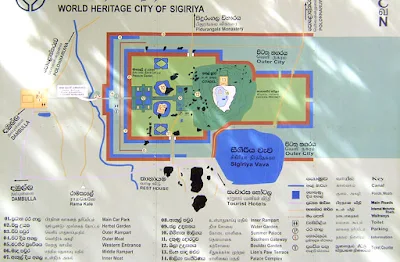
Sigiriya consists of an ancient citadel built by King Kashyapa during the 5th century. The Sigiriya site contains the ruins of an upper palace located on the flat top of the rock, a mid-level terrace that includes the Lion Gate and the mirror wall with its frescoes, the lower palaces located behind the lavish lower gardens, and moats and ramparts which protected the citadel. The site was both a palace and a fortress. The upper palace on the top of the rock includes cisterns cut into the rock. The moats and walls that surround the lower palace are exquisitely beautiful.

Frescoes:-

John Still in 1907 suggested, "The whole face of the hill appears to have been a gigantic picture gallery... the largest picture in the world perhaps". The paintings would have covered most of the western face of the rock, an area 140 meters long and 40 meters high. There are references in the graffiti to 500 ladies in these paintings. However, most have been lost forever. More frescoes, different from those on the rock face, can be seen elsewhere, for example on the ceiling of the location called the "Cobra Hood Cave".

Although the frescoes are classified as in the Anuradhapura period, the painting style is considered unique; the line and style of application of the paintings differing from Anuradhapura paintings. The lines are painted in a form which enhances the sense of volume of the figures. The paint has been applied in sweeping strokes, using more pressure on one side, giving the effect of a deeper color tone towards the edge. Other paintings of the Anuradhapura period contain similar approaches to painting, but do not have the sketchy lines of the Sigiriya style, having a distinct artists' boundary line. The true identity of the ladies in these paintings still have not been confirmed. There are various ideas about their identity. Some believe that they are the ladies of the king's while others think that they are women taking part in religious observances. These pictures have a close resemblance to paintings seen in the Ajanta caves in India.

The Mirror Wall:-

Originally this wall was so highly polished that the king could see himself whilst he walked alongside it. Made of brick masonry and covered in highly polished white plaster, the wall is now partially covered with verses scribbled by visitors, some of them dating from as early as the 8th century. People of all types wrote on the wall, on varying subjects such as love, irony, and experiences of all sorts. Further writing on the mirror wall now has been banned for the protection of the old writings.

The Sri Lankan archaeologist Dr Senerat Paranavitana deciphered 685 verses written in the 8th, 9th and 10th centuries CE on the mirror wall. One such poem from these long-past centuries, roughly translated from Sinhala, is:

    "I am Budal [the writer's name]. Came with hundreds of people tо see Sigiriya. Since аll the others wrote poems, I did not!"

The Gardens:-

The Gardens of the Sigiriya city are one of the most important aspects of the site, as it is among the oldest landscaped gardens in the world. The gardens are divided into three distinct but linked forms: water gardens, cave and boulder gardens, and terraced gardens.

The Water Gardens:-

The water gardens can be seen in the central section of the western precinct. Three principal gardens are found here. The first garden consists of a plot surrounded by water. It is connected to the main precinct using four causeways, with gateways placed at the head of each causeway. This garden is built according to an ancient garden form known as char bagh, and is one of the oldest surviving models of this form.

The second contains two long, deep pools set on either side of the path. Two shallow, serpentine streams lead to these pools. Fountains made of circular limestone plates are placed here. Underground water conduits supply water to these fountains which are still functional, especially during the rainy season. Two large islands are located on either side of the second water garden. Summer palaces are built on the flattened surfaces of these islands. Two more islands are located farther to the north and the south. These islands are built in a manner similar to the island in the first water garden.
The gardens of Sigiriya, as seen from the summit of the Sigiriya rock

The third garden is situated on a higher level than the other two. It contains a large, octagonal pool with a raised podium on its northeast corner. The large brick and stone wall of the citadel is on the eastern edge of this garden.

The water gardens are built symmetrically on an east-west axis. They are connected with the outer moat on the west and the large artificial lake to the south of the Sigiriya rock. All the pools are also interlinked using an underground conduit network fed by the lake, and connected to the moats. A miniature water garden is located to the west of the first water garden, consisting of several small pools and watercourses. This recently discovered smaller garden appears to have been built after the Kashyapan period, possibly between the 10th and 13th centuries.

The Boulder Gardens:-

The boulder gardens consist of several large boulders linked by winding pathways. The gardens extend from the northern slopes to the southern slopes of the hills at the foot of Sigiris rock. Most of these boulders had a building or pavilion upon them; there are cuttings that were used as footings for brick walls and beams.They were used to be pushed off from the top to attack enemies when they approached.

The Terraced Gardens:-

The terraced gardens are formed from the natural hill at the base of the Sigiriya rock. A series of terraces rises from the pathways of the boulder garden to the staircases on the rock. These have been created by the construction of brick walls, and are located in a roughly concentric plan around the rock. The path through the terraced gardens is formed by a limestone staircase. From this staircase, there is a covered path on the side of the rock, leading to the uppermost terrace where the lion staircase is situated.

For more details - Sigiriya

Apr 12, 2017

Mysterious Patiala Necklace " The $125 Million Necklace Has the World's Seventh Largest, The DeBeers Diamond"

The Patiala Necklace was made for Maharaja Sir Bhupinder Singh of Patiala who ascended the throne in 1900 as an eight-year-old was the archetypal Indian potentate- scores of palaces, fleets of Rolls-Royces and a harem. But his prized accoutrement was the necklace fashioned for him by Cartier in 1928. It had five rows of platinum chains embedded with 2,930 diamonds, including the world's seventh largest, the DeBeers diamond.
The Patiala Necklace was a necklace created by the House of Cartier in 1928. It was made for and named after Bhupinder Singh of Patiala, the then ruling Maharaja of the state of Patiala. It contained 2,930 diamonds, including as its centerpiece, the world's seventh largest diamond, the "De Beers", that had a 428 carat per-cut weigh, and weighed 234.65 carats in its final setting. The piece also contained seven other diamonds ranging from 18 to 73 carats, and a number of Burmese rubies

Not long after the formation of De Beers Consolidated Mines Limited in March 1888, a huge light yellow octahedral crystal was found in the De Beers Mine. The gem weighed 428.50 old carats (old carats being the pre-1913 non-metric carat) and measured 47.6 mm through its longest axis and 38.1 mm square. Excluding Victoria, aka the Great White or Jacob, the source of which remains doubtful, the De Beers was the largest diamond found at the four mines at Kimberly during the time period.

After its display in Paris the Maharaja of Patiala bought the De Beer. The Parisian jewellery workshops of Cartier SA had received a very special delivery: an overflowing trunk of precious stones and jewellery, including the De Beers diamond.

The delivery had been sent from the Maharaja of Patiala, Bhupinder Singh, with a short request from him to “create a ceremonial necklace worthy enough for a King”

The astonishing Patiala Necklace was created by the famous House of Cartier. With three years of intense labor and patience, the iconic Collier de Patiala, or the Patiala Necklace, was presented in 1928.


The necklace was perhaps the most spectacular and most expensive piece of jewellery ever created and the largest single commission that Cartier has ever executed. 
For the next 10 years, from 1928 to his death in 1938 The Maharaja of Patiala would be seen adorning the necklace on many official events. During this time he also became perhaps the most famous Maharaja of Patiala, being best known for his incredible extravagance.

According to an account by Alain Boucheron on his family business in the book “The Master Jewelers” that was cited in the Times:

                             The flamboyant Maharajah… arrived at Boucheron’s in 1927 accompanied by a retinue of 40 servants all wearing pink turbans, his 20 favorite dancing girls and, most important of all, six caskets filled with 7571 diamonds, 1432 emeralds, sapphires, rubies and pearls of incomparable beauty.”

During his adult life he sired an estimated 88 children of whom at least 53 survived him. Upon his death the necklace was locked in the Royal Treasury of Patiala. During the next 10 years the necklace was removed for special occasions and ceremonies. A detailed record of this events was recorded by the treasury.

The $125 million necklace sparked controversy, when it discovered to have mysteriously disappeared from the royal treasury of Patiala in April 1948.

The last Person to wear it was Maharaja Yadavindra Singh, son of Maharaja Bhupinder Singh at a royal banquet. Reports claim the state fell on hard times and stones from this necklace were dismantled and sold off separately – but this has been denied and no records of any sale are in existence.

In 1982, at a Sotheby’s auction in Geneva, the “De Beers” diamond reappeared. There, it was sold for $3.16 million with no providence and 50 years later in 1998 (from 1948), Eric Nassbaum, a Cartier representative, stumbled upon the remnants of the necklace in a small antique shop in London. All the big stones were gone, including the De Beers and along with the seven surrounding diamonds.

It was purchased by Cartier whom attempted to restore it to its former glory. The large jewels are still missing, in particular, the Burmese rubies as well as the 18 to 73 carat stones that were mounted on a pendant.
Cartier who had purchased the incomplete necklace and, after four years, restored it to resemble the original. They replaced the lost diamonds with cubic zircon and synthetic diamonds, and mounted a replica of the original De Beers diamond.

The Badminton Cabinet (Most Expensive Piece of Furniture in The World)

The Badminton cabinet is a monumental piece of 18th-century furniture that twice set the record for most expensive piece of furniture ever sold. In 2004, the Badminton Cabinet sold at auction for a record US$36.7 million, making it the most expensive piece of  furniture in the world.

The chest was originally commissioned in 1726 by Henry Somerset, third Duke of Beaufort. He was on a grand tour of Europe, and passing through Florence, the 19-year-old duke made a rare private request to the Medici workshop. Among the last great works of art made in Florence under the Medici family and the greatest work of the Grand Ducal workshop, the cabinet took 30 craftsmen some six years to produce. The duke paid about £500 for the decorative masterpiece, named for Badminton House, his seat in Gloucestershire.

The Florentine ebony chest measures 3.8 metres tall by 2.3 metres wide, supported by stately legs and crowned with a gilded bronze top. The chest is inlaid with semiprecious stones in an elaborate surface decoration. Medici artisans used a technique called pietra dura to create painterly scenes across the surface of the grand cabinet using gems and semi-precious stones. Brilliant lapis lazuli, amethyst quartz, red and green jasper, and other gems form dazzling scenes of birds darting among beribboned flower gardens, fruit and foliage, lions, and satyrs. Rendered in bronze are the four seasons and the coat of arms. At its center is a clock using fleurs-de-lis as numbers.


But the Badminton Cabinet always has been in a class of its own. It has been called the greatest work of the Grand Ducal workshops and the last great work of art made in Florence under the Medici family.

Beyond the architectural statement of gilded bronze tops and stately legs, the elaborate surface decoration almost defies description. Inlays of brilliantly colored lapis lazuli, amethyst quartz, red and green jasper and other semiprecious stones portray birds flitting among sprays of flowers and ribbons. Swags of bronze foliage are encrusted with hard-stone fruit. Lions, grotesques and satyrs appear on drawer fronts and doors. The Four Seasons are rendered in bronze, along with the coat of arms of the English aristocrat for whom the cabinet was created.

The ornate cabinet was installed in Badminton House, where it stayed in relative obscurity until the late 20th century, when Somerset’s descendants auctioned it to settle estate taxes. In 1990, the Badminton Cabinet sold for US$15.2 million at auction in Christie’s, the world record for a piece of furniture at the time. In 2004, the impressive chest went back on the auction block at Christie’s. After a contentious bidding battle, the director of the Lichtenstein Museum in Vienna, acting on behalf of Prince Hans-Adam II of Lichtenstein, placed the winning bid: US$36,662,106.

The piece now rests in the Lichtenstein Museum for all to enjoy its ebullient baroque craftsmanship.