Mar 20, 2017

The Richat Structure (Eye of the Sahara), Sahara Near Ouadane, West–Central Mauritania

The Richat Structure, also known as the Eye of the Sahara and Guelb er Richat, is a prominent circular feature in the Sahara near Ouadane, west–central Mauritania.

The Richat Structure is a deeply eroded, slightly elliptical dome with a diameter of 40 kilometers (25 mi). The sedimentary rock exposed in this dome ranges in age from Late Proterozoic within the center of the dome to Ordovician sandstone around its edges. The sedimentary rocks comprising this structure dip outward at 10°–20°. Differential erosion of resistant layers of quartzite has created high-relief circular cuestas. Its center consists of a siliceous breccia covering an area that is at least 30 kilometers (19 mi) in diameter.


Exposed within the interior of the Richat Structure are a variety of intrusive and extrusive igneous rocks. They include rhyolitic volcanic rocks, gabbros, carbonatites and kimberlites. The rhyolitic rocks consist of lava flows and hydrothermally altered tuffaceous rocks that are part of two distinct eruptive centers, which are interpreted to be the eroded remains of two maars. According to field mapping and aeromagnetic data, the gabbroic rocks form two concentric ring dikes. The inner ring dike is about 20 m in width and lies about 3 km from the center of Richat Structure. The outer ring dike is about 50 m in width and lies about 7 to 8 km from the center of this structure. Thirty-two carbonatite dikes and sills have been mapped within the Richat Structure. The dikes are generally about 300 m long and typically 1 to 4 m wide. They consist of massive carbonatites that are mostly devoid of vesicles. The carbonatite rocks have been dated as having cooled between 94 and 104 million years ago. A kimberlitic plug and several sills have been found within the northern part of the Richat Structure. The kimberlite plug has been dated to around 99 million years old. These intrusive igneous rocks are interpreted as indicating the presence of a large alkaline igneous intrusion that currently underlies the Richat Structure and created it by uplifting the overlying rock.

Spectacular hydrothermal features are a part of the Richat Structure. They include the extensive hydrothermal alteration of rhyolites and gabbros and a central megabreccia created by hydrothermal dissolution and collapse. The siliceous megabreccia is at least 40 m thick in its center to only a few meters thick along its edges. The breccia consists of fragments of white to dark gray cherty material, quartz-rich sandstone, diagenetic cherty nodules, and stromatolitic limestone and is intensively silicified. The hydrothermal alteration, which created this breccia, has been dated to have occurred about 98.2 ± 2.6 million years ago using the 40Ar/39Ar method.

Initially interpreted as an asteroid impact structure because of its high degree of circularity, the Richat Structure is now regarded by geologists as a highly symmetrical and deeply eroded geologic dome. After extensive field and laboratory studies, no credible evidence has been found for shock metamorphism or any type of deformation indicative of a hypervelocity extraterrestrial impact. While coesite, an indicator of shock metamorphism, had initially been reported as being present in rock samples collected from the Richat Structure, further analysis of rock samples concluded that barite had been misidentified as coesite. In addition, the Richat Structure lacks the annular depression that characterizes large extraterrestrial impact structures of this size. Also, it is quite different from large extraterrestrial impact structures in that the sedimentary strata comprising this structure is remarkably intact and "orderly" and lacking in overturned, steeply dipping strata or disoriented blocks. A more recent multianalytical study on the Richat megabreccias concluded that carbonates within the silica-rich megabreccias were created by low-temperature hydrothermal waters, and that the structure requires special protection and further investigation of its origin.

For More Details - Richat Structure

Princess Juliana International Airport, Simpson Bay, Sint Maarten

Princess Juliana International Airport (also known as Saint Maarten International Airport) is the main airport on the Caribbean island of Saint Martin, located on the Dutch side of the island in the country of Sint Maarten. In 2010, the airport handled 1,645,105 passengers and 60,870 aircraft movements. The airport serves as a hub for Windward Islands Airways and is the major gateway for the smaller Leeward Islands, including Anguilla, Saba, St. Barthélemy and St. Eustatius. It is named after Juliana of the Netherlands, who as crown princess landed here in 1944, the year after the airport opened. There is also an airport on the French side of the island, called Aéroport de Grand Case or L'Espérance Airport.

The airport is perhaps best known for very low-altitude flyover landing approaches due to one end of its runway being extremely close to the shore and Maho Beach.


The airport was started as a military airstrip in 1942. It was converted to a civilian airport in 1943. In 1964 the airport was remodeled and relocated, with a new terminal building and control tower. The facilities were upgraded in 1985 and 2001. Because of increased passenger traffic and the expected growth of passenger traffic in the near future, Princess Juliana International Airport is being heavily modernized following a three-phased masterplan, commissioned in 1997.

Phase I was a short-term program in order to upgrade existing facilities and improve the level of service at various points. This included widening, strengthening and renovating the runway, increasing the bearing capacity of the taxiways, construction of a new apron and an upgrade of the (old) terminal. Phase I was completed in 2001.

Phase II included the construction of a radar facility and a new air traffic control tower, the construction of a new and more modern, 27,000 square metres (290,000 sq ft), terminal, capable of handling 2.5 million passengers per year, and the construction of a Runway End Safety Area (RESA) of 150 metres (490 ft), including a 60 metres (200 ft) overrun, on both ends of its runway, to comply with ICAO rules. The new air traffic control tower and the radar station commenced operations on 29 March 2004, while the new terminal opened in late October 2006. The terminal has 4 jetways for large aircraft like 747s.

If traffic develops as forecast, Phase III of the masterplan will be executed, consisting of an extension of the new terminal building and the construction of a full parallel taxiway system. The new terminal building will also have more jetways and services etc.

However, the oil price increases since 2003 began impacting discretionary air travel worldwide by early 2008, and the prospect of further price increases threatens to reverse the recent expansion of tourist travel by jet which began with the 1980s oil glut.

In 1994, the Kingdom of the Netherlands and France signed the Franco-Dutch treaty on Saint Martin border controls, which allows for joint Franco-Dutch border controls on so-called "risk flights". After some delay, the treaty was ratified in November 2006 in the Netherlands, and subsequently entered into force on 1 August 2007.

In July 2016, KLM announced to serve the airport with direct flights from Amsterdam instead by a triangle route via Curaçao from October 2016. Due to this change, the airport lost its last regular Boeing 747 service - which was a famous photo opportunity on the nearby beach - as KLM uses Airbus A330s for the changed schedule.

Because the approach to Runway 10 is over water, pilots can become disoriented regarding their perceived altitude when operating under visual flight rules. Normal instrument checks, coupled with experience and situational awareness, mitigate potential problems. The departure from Runway 10 presents more "difficulties" than the approach, with a turn required to avoid mountains in the departure path.

Arriving aircraft approach the island on the last section of the final approach for Runway 10, following a 3° glide slope flying low over the famous Maho Beach. Pictures of low flying aircraft were published in several news magazines worldwide in early 2000. The thrilling approaches and ease of access for shooting spectacular images, made the airport one of the world's favorite places among planespotters. To meet changing international and local regulations a 150-metre (490 ft) safety extension was required.

Despite the reputed difficulties in approach, there have been no records of major incidents at the airport, although ALM Flight 980 crashed 30 miles (48 km) from St. Croix on 2 May 1970, after several unsuccessful landing attempts at TNCM in bad weather. Runway 10/28 was renumbered from 09/27 in late 2008. The runway is 45m wide.

Mar 19, 2017

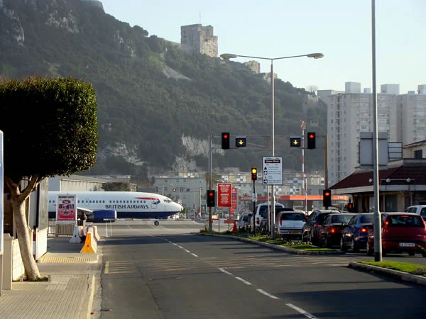
Gibraltar International Airport, Gibraltar, Iberian Peninsula

Gibraltar International Airport or North Front Airport is the civilian airport that serves the British overseas territory of Gibraltar. The runway is owned by the Ministry of Defence for use by the Royal Air Force as RAF Gibraltar. Civilian operators use the civilian-operated terminal. National Air Traffic Services hold the contract for provision of air navigation services at the airport.

In 2015, the airport handled 444,336 passengers and 408,757 kg of cargo on 4,100 total flights. Winston Churchill Avenue (the main road heading towards the land border with Spain) intersects the airport runway, and consequently has to be closed every time a plane lands or departs. The History Channel programme Most Extreme Airports ranked the airport the fifth most extreme airport in the world. It is exposed to strong cross winds around the rock and across the Bay of Algeciras, making landings in winter particularly uncomfortable.

Monarch Airlines is the largest operator at Gibraltar International, operating flights to Birmingham, London Gatwick, London Luton, Manchester Airport. Both routes are operated by an Airbus A320-200. easyJet operates seven weekly flights to London Gatwick operated by Airbus A320 family aircraft, as well as 3 flights per week to Bristol Airport and 2 flights a week to Manchester Airport. British Airways also operates nine weekly flights to London Heathrow being operated by an Airbus A320-200. Royal Air Maroc Express also operate twice weekly flights to Tangier Ibn Battouta Airport, which continue onto Casablanca Airport.

Although located in Gibraltar, the airport is also used by people travelling to or from neighbouring parts of southern Spain such as the Costa del Sol or the Campo de Gibraltar.


There is one terminal at Gibraltar International. Flight departures moved into the new terminal on 26 September 2012 when the old terminal was closed on 25 September 2012.

The old terminal at the airport was built in 1959 and refurbished in the late 1990s. For many years, it had been too small to cope with the number of passengers. The size of the terminal was 20,000 m2 (220,000 sq ft), and had 10 check-in desks, one baggage carousel, one security gate and two departure gates. The departure gates then enabled passengers to board a bus which takes them to one of the new stands. On 26 November 2011, arriving flights switched to the new terminal as the first phase of the new terminal opened. On 25 September 2012, the old terminal closed its doors as flight departures moved into the new terminal on 26 September 2012. The last flight to use it was easyJet flight EZY8904 to London-Gatwick. The old terminal building was demolished in February 2014 and will make way for a new coach park.

A new terminal has been constructed at Gibraltar International due to increasing number of passengers. Planning permission was announced in 2007 with construction of the new terminal began in 2009 and was finished by 2011. The first phase of the new terminal opened on 26 November 2011 for arriving flights only. The second phase of the new terminal opened on 26 September 2012 when flight departures moved. The first flight to use the first phase was easyJet flight EZY7295 from Liverpool and the first flight to use the second phase was British Airways flight BA491 to London Heathrow. The terminal's terrace was inaugurated by the Earl of Wessex, Prince Edward on 13 June 2012.

The terminal is 35,000 m2 (380,000 sq ft), which is 15,000 m2 (160,000 sq ft) bigger than the old terminal. It has two baggage carousels and three departure gates, none of which are equipped with jet bridges. Only one of the two baggage carousels is in use for flights. It has a passenger capacity of up to 1.5 million passengers per year. Retail services are also available in the terminal and these include WH Smith, 36 North Bar and Gibraltar Duty Free Stores. A new general aviation area has also been built inside the terminal to handle private aircraft.

The road across the runway is constraining operations at the airport, especially with the increase in operations since the Córdoba Agreement. Prior to this agreement, only three flights operated daily to Gatwick and Luton, and three flights a week to Manchester. On busy days, at present, some seven flights now arrive and depart. If the average time the road is closed for an aircraft to land or depart is ten minutes, then on certain days the road can be closed for over two hours.

Because of this, a new four-lane diversion road and tunnel section was planned. The new runway tunnel will reduce delays and tailbacks caused by aircraft taking off and landing. Construction of the new road was due to begin in January 2008 and be completed by the beginning of 2009, however in 2016 it was still not completed. The road across the runway will remain in place, for exceptional, specific or emergency use. But it will not be available for routine day-to-day, only for private vehicular traffic. Pedestrians will not be required to travel via the new road/tunnel, and will continue to cross the runway at the present location. A prolonged litigation between the Government of Gibraltar and contractor OHL over the delay was resolved in June 2016 with an agreement for OHL to complete the works at a price of 24 million GBP and a projected finish date of November 2018.

A new dual carriageway is also being built. It will pass under the new terminal and towards the eastern edge of the runway at which point it will pass through a tunnel under it and connect via a roundabout with Devil's Tower Road on the opposite side of the runway. After the road tunnel on the north side of the runway the new road will run parallel to the frontier, passing under the air terminal fly-over section. The road will then branch into two, with one road leading to the loop and the frontier, and another leading to the Air Terminal, North Front and Winston Churchill Avenue.

for more details = Gibraltar International Airport

Islas Marietas National Park (hidden beach), Nayarit, Mexico

The Marieta Islands are a group of small uninhabited islands a few miles off the coast of the state of Nayarit, Mexico, in federal waters 7.9 kilometres (4.9 mi) southwest of the peninsula known as Punta de Mita, in the municipality of Bahía de Banderas.

They are very popular tourist destinations because of the abundant marine life populations due to the islands being protected from fishing and hunting by the Mexican government. The depth around the islands is between 70 and 110 feet.


The Marietas Islands were originally formed many thousands of years ago by volcanic activity, and are completely uninhabited. The islands are about an hour long boat ride west-northwest from the coast of Puerto Vallarta and are visited daily by hundreds of tourists, yet no one can legally set foot on the islands. In the early 1900s the Mexican government began conducting military testing on the islands because no one lived there. Many bombings and large explosions took place on the islands causing caves and rock formations to be created. After a massive international outcry, started by scientist Jacques Cousteau in the late 1960s, the government eventually decided to label the islands a national park and therefore protected against any fishing, hunting or human activity.

Situated in a sort of open sun-drenched crater, this beach is affectionately nicknamed the "hidden beach" or "beach of love" (Playa del Amor), it is accessible only when the tide is low.

The Islands are home to 44 different species of plants and wildlife. This has led to the inclusion of National Park in RAMSAR sites its designation as a UNESCO MAB Biosphere Reserve. Many species of seabirds use the location as feeding and breeding grounds, these include blue-footed boobies as well as the red-billed tropicbirds. It also has many different varieties of coral, which, in turn, is home to a large variety of reef fish species. The island ecosystem is also home to dolphins, Manta Rays and a number of tropical fish. Eels and many species of sea turtles are also found in the reefs and the many caves that dot the site. During the winter months humpback whales arrive at the islands and can be observed all through winter.

Protection by the government has created an environment conducive to the development of the marine ecosystem, and is a popular location for snorkeling and scuba diving. Not even during whale watching tours, people often report seeing sea turtles, manta rays, octopus, wild dolphins, humpback whales and thousands of species of tropical fish around the islands. The islands are also home to a few thousand birds, with species such as the blue-footed booby. Currently, the Mexican government allows only a few companies to go to the islands and allows the landing of passengers onto one secluded beach with the necessary permit from Semarnat.

From Punta de Mita, small boats do tours through the islands to see the wildlife of this region. From December to March gray and humpback whales can be observed that come from Alaska to give birth off the coast of  Nayarit.

It has been estimated in studies carried out at the University of Guadalajara that the so-called "hidden beach" or the "love beach" can accommodate up to 116 visitors a day without degrading. The carrying capacity of the entire park is 625 visitors a day. (These studies used the antiquated system of Tourism carrying capacity to estimate visitors). However the actual number of visitors is typically three of four times this limit with more than 2500 visitors landing on it each day during 2016. During the Easter holidays more than 250 boats landed on the island per day, some of them carrying as many as 400 tourists. This has been due to recent interest in the Island. The number of tourists in 2012 was only 27,500, but this skyrocketed to 127,372 in 2015.

For More Details - Islas Marietas National Park