May 30, 2021

The Rock Islands, Southern Lagoon of Palau, Between Koror and Peleliu, Koror State.

The Rock Islands of Palau, also called Chelbacheb, are a collection of several hundred small limestone or coral uprises in the Southern Lagoon of Palau between Koror and Peleliu, now an incorporated part of Koror State. There are between 250 and 300 islands in the group according to different sources, with an aggregate area of 42 square kilometres (16 sq mi) and a maximum height of 207 meters (679 ft). The islands were declared a UNESCO World Heritage Site in 2012

The Rock Islands are sparsely populated and famous for their beaches, blue lagoons, and the peculiar umbrella-like shapes of many of the islands themselves. Many of the islands display a mushroom-like shape with a narrower base at the intertidal notch. The indentation comes from erosion and from the dense community of sponges, bivalves, chitons, snails, urchins, and others that graze mostly on algae.

Rock Islands Southern Lagoon covers includes 445 uninhabited limestone islands of volcanic origin. Many of them display unique mushroom-like shapes in turquoise lagoons surrounded by coral reefs. The aesthetic beauty of the site is heightened by a complex reef system featuring over 385 coral species and different types of habitat. They sustain a large diversity of plants, birds and marine life including dugong and at least thirteen shark species. The site harbours the highest concentration of marine lakes anywhere, isolated bodies of seawater separated from the ocean by land barriers. They are among the islands’ distinctive features and sustain high endemism of populations which continue to yield new species discoveries. The remains of stonework villages, as well as burial sites and rock art, bear testimony to the organization of small island communities over some three millennia. The abandonment of the villages in the 17th and 18th centuries illustrates the consequences of climate change, population growth and subsistence behaviour on a society living in a marginal marine environment.

A 4,912 ha site encompassing the Rock Islands has been designated an Important Bird Area (IBA) by BirdLife International because it supports populations of most of Palau’s endemic birds, including Micronesian megapodes, Palau ground doves, Micronesian imperial pigeons, Palau fruit doves, swiftlets and kingfishers, Micronesian myzomelas, morningbirds, Palau fantails, flycatchers and bush warblers, giant, dusky and citrine white-eyes, and Micronesian starlings.


The islands and surrounding reefs include Palau's most popular tourist sites, such as the Blue Corner, Blue Holes, German Channel, Ngermeaus Island, and the famed Jellyfish Lake, one of many marine lakes in the Rock Islands that provides home and safety for several kinds of stingless jellyfish found only in Palau. It is the most popular diving destination in Palau, offering some of the most diverse dive sites on the planet, from wall diving and high current drift dives, to manta rays and sharkfeeds, to shallow lagoons, decorated caves, and overhangs. Tourist attractions also include Dolphin Bay, where a staff of veterinarians and trainers educate guests about dolphins.

The only inhabited place on the islands is called Dolphin  Bay (on Ngeruktabel, 5 km from Koror). It is the location of Palau's national aquatics park, and  hosts headquarters of Palau's Park rangers.


The marine site covers 100,200 ha and is characterized by coral reefs and a diversity of other marine habitats, as well as 445 coralline limestone islands uplifted due to volcanism and shaped over time by weather, wind and vegetation. This has created an extremely high habitat complexity, including the highest concentration of marine lakes in the world, which continue to yield new species discoveries. The terrestrial environment is lush and at the same time harsh, supporting numerous endemic and endangered species. Although presently uninhabited, the islands were once home to Palauan settlements, and Palauans continue to use the area and its resources for cultural and recreational purposes. This is regulated through a traditional governance system that remains an important part of national identity.

The islands contain a significant set of cultural remains relating to an occupation over some five thousand years that ended in abandonment. Archaeological remains and rock art sites are found in two island clusters - Ulong and Negmelis, and on three islands - Ngeruktabel, Ngeanges, and Chomedokl. Remains of former human occupation in caves, including rock art and burials, testifies to seasonal human occupation and use of the marine ecosystem, dating back to 3,100 BP and extending over some 2,500 years.

Permanent stone villages on a few islands, some dating back to between 950 and 500 BP, were occupied for several centuries before being abandoned in the 17th-18th centuries, when the population moved to larger islands. The villages include the remains of defensive walls, terraces and house platforms. The settlements reflect distinctive responses to their local environment and their abandonment demonstrates the consequences of population growth and climate change impacting on subsistence in a marginal environment.

The descendants of the people who moved from the Rock Islands to the main islands of Palau identify with their ancestral islands through oral traditions that record in legends, myths, dances, and proverbs, and traditional place names the land- and seascape of their former homes.

May 29, 2021

Matsumoto Castle ( Premier Historic Castles), Matsumoto, Nagano, Japan

Matsumoto Castle originally known as Fukashi Castle, is one of Japan's premier historic castles, along with Himeji and Kumamoto. The building is also known as the "Crow Castle" due to its black exterior. It was the seat of Matsumoto Domain under the Edo Period Tokugawa shogunate. It is located in the city of Matsumoto, in Nagano Prefecture and is within easy reach of Tokyo by road or rail.

The keep (tenshukaku), which was completed in the late sixteenth century, maintains its original wooden interiors and external stonework. It is listed as a National Treasure of Japan, and is one of the twelve remaining original tenshu in Japan. Matsumoto Castle is a flatland castle (hirajiro) because it is not built on a hilltop or amid rivers, but on a plain. Its complete defences would have included an extensive system of inter-connecting walls, moats, and gatehouses.


The castle's origins go back to the Sengoku period. A fortification was built at this located by the shugō of Shinano Province, Shimadachi Sadanaga of the Ogasawara clan during the Eisho era (1504-1520). This minor border post was originally was called Fukashi Castle. In 1550 it was seized by the Takeda clan following the Siege of Fukashi. Takeda Shingen appointed his retainer Baba Nobuharu as castellan, and the castle was the Takeda field headquarters for their conquest of the Matsumoto Basin and as a redoubt in the constant conflict between the Takeda and the powerful Uesugi clan to the north. Following the defeat of the Takeda clan by Oda Nobunaga in 1582, the castle was surrendered to Oda Nagamasu, but it was soon reassigned to Kiso Yoshimasa. However, with the assassination of Oda Nobunaga in 1582, the castle was seized by Ogasawara Dosetsuzai with the backing of Uesugi Kagekatsu. His nephew, Ogasawara Sadayoshi, later pledged fealty to Tokugawa Ieyasu, and renamed the castle "Matsumoto Castle".

Following Toyotomi Hideyoshi's conquest of Odawara in 1590, Tokugawa Ieyasu was transferred from his ancestral domains to the Kantō region, and Ishikawa Kazumasa was placed in charge of Matsumoto. Kazumasa and his son Yasunaga built the tower and other parts of the castle, including the three towers: the tenshu and the small yagura in the northwest, both begun in 1590, and the Watari Yagura; the residence; the drum gate; the black gate, the Tsukimi Yagura, the moat, the innermost bailey, the second bailey, the third bailey, and the sub-floors in the castle, much as they are today. They also were instrumental in laying out the castle town and its infrastructure. It is believed much of the castle was completed by 1593–94.

During the Edo period, the Tokugawa shogunate established the Matsumoto Domain. The Ogasawara returned briefly as daimyō of Matsumoto from 1613 to 1617. They were followed by the Toda-Matsudaira clan from 1617-1633, Matsudaira clan from 1633-1638, Hotta clan from 1638-1642, Mizuno clan from 1642-1725 and by the Toda-Matsudaira clan again from 1725 to the Meiji restoration in 1868.

In 1872, the new Meiji government ordered the destruction of all former feudal fortifications. Most of the castle structures were razed, and the outer grounds of Matsumoto Castle were sold off at auction for redevelopment. However, when news broke that the tenshu was going to be demolished, however, an influential figure from Matsumoto, Ichikawa Ryōzō, along with residents from Matsumoto, started a campaign to save the building. Their efforts were rewarded when the tower was acquired by the city government. The daimyo residence in the Ni-no-Maru enclosure was also preserved for use as the prefectural office for Chikuma Prefecture; however, it was burned down in an act of arson in 1876. At the time, Chikuma and Nagano prefectures were about to be merged to form modern-day Nagano Prefecture, and there was a controversy over where to locate the prefectural capital. The loss of this building decided the location in favor of Nagano city, and the Matsumoto District Court was built on the site in 1878.


In the late Meiji period the tenshu started to lean to one side. It was because of neglect coupled with a structural defect, but many people believed the tower leaned due to the curse of Tada Kasuke. He had been caught and executed for attempting to appeal unfair tax laws (Jōkyō uprising). A local high school principal, Kobayashi Unari, decided to renovate the castle and appealed for funds. The castle underwent "the great Meiji renovation" between 1903-1913. The castle was designated a National Historic Site in 1930, and the five surviving original structures (Tenshu, Inui-ko-tenshu (small northern tower), Watari-yagura (roofed passage), Tatsumi-tsuke-yagura (southern wing), and Tsukimi-yagura (moon-viewing room) ) were designated as National Treasures of Japan in 1952. This enabled access to government funding for a major restoration project from 1950 to 1955, during which these buildings were dismantled and rebuilt.

In 1990, the Kuromon-Ninomon (second gate of the Black Gate) and sodebei (side wall) were reconstructed. The square drum gate was reconstructed in 1999. On April 6, 2006 Matsumoto Castle was selected as one of Japan's Top 100 Castles. Matsumoto Castle was damaged in a 5.4 magnitude earthquake on June 30, 2011. The quake caused approximately ten cracks in the inner wall of the main tower. There is a plan for restoring the soto-bori  (outer moat), which was reclaimed for a residential zone.The second floor of the main  keep features a gun museum, Teppo Gura, with a collection of guns, armor, and other  weapons.

The wooden interior of Matsumoto Castle provides an authentic experience unlike that felt at many other castles rebuilt of ferro-concrete. Interesting features of the castle include steep wooden stairs, openings to drop stones onto invaders, openings for archers, as well as an observation deck at the top, sixth floor of the main keep with nice views over the surrounding city.

In spring, Matsumoto Castle is a popular cherry blossom spot. Many visit to stroll around the spacious castle grounds and park. Along the outer castle moat are hundreds of somei yoshino cherry trees that provide lovely views when they are in full bloom around mid April each year.

May 28, 2021

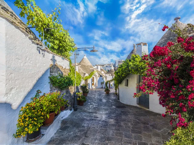
Alberobello, Metropolitan City of Bari, Apulia, Itally

Alberobello is a small town and comune of the Metropolitan City of Bari, Apulia, southern Italy. It has 10,735 inhabitants and is famous for its unique trullo buildings. The trulli of Alberobello have been designated as a UNESCO World Heritage site since 1996    

A first occupation of the area started only in the early sixteenth century on the impulse of the Count of Conversano Andrea Matteo III Acquaviva d'Aragona. He allowed about forty peasant families from Noci to settle here and cultivate the land, with the obligation to give him the tenth of the crops.


The property comprises six land parcels extending over an area of 11 hectares. The land parcels comprise two districts of the city  and four specific locations. The extent and homogeneity of those areas, the persistence of traditional building techniques, together with the fact that trulli are still inhabited make this property an exceptional Historic Urban Landscape.

Trulli are traditional dry stone huts with a corbelled roof. Their style of construction is specific to the Itria Valley in the region of Puglia
are remarkable examples of drywall (mortarless) construction, a prehistoric building technique still in use in this region. The trulli are made of roughly worked limestone boulders collected from neighbouring fields. Characteristically, they feature pyramidal, domed or conical roofs built up of corbelled limestone slabs. Trulli were generally constructed as temporary field shelters and storehouses or as permanent dwellings by small-scale landowners or agricultural labourersIn 1635 his successor, Count Giangirolamo II (1600-1665) erected an inn with a tavern and an oratory and started the urbanization of the forest with the construction of few small houses. The expansion of the urban area was helped by the abundance of limestone, karst and calcareous sedimentary, and by the permission of the count to build houses only with dry walls without the use of mortar, which would become the peculiar trulli. This obligation to have houses built with dry stones was an expedient of the count to avoid paying taxes to the Spanish viceroy of the Kingdom of Naples. The centre of Alberobello was built on the streets of the ancient river Cana, where is now the largo Giuseppe Martelotta.

Alberobello remained a fief of the Acquaviva of Aragon until  May 27, 1797, when King Ferdinand IV of Bourbon elevated the small village to the royal  city, freeing it from the feudal servitude of the counts. On 22 June 1797, the first mayor  Francesco Giuseppe Lippolis was  elected.


Alberobello is the only inhabited center with an entire district of trulli. It is therefore considered the cultural capital of the trulli of the Valle d'Itria.

The history of the trulli is linked to the Prammatica De Baronibus, an edict of the 15th-century Kingdom of Naples that subjected every new settlement to a tribute. In 1481 the Counts of Conversano D'Acquaviva D'Aragona from 1481, owners of the territory of Alberobello, then imposed on the residents that they built their dwellings dry, without using mortars, so that they could be configured as precarious buildings and easily demolished.

Having to use only stones, the peasants found in the round form with self-supporting domed roof the simplest configuration. The roofs were embellished with decorative pinnacles representing the signature of the architect.

May 27, 2021

Malshej Ghat, Western Ghats Range in the Kalyan, Ahmednagar Road of Maharashtra, India.

Malshej Ghat is a mountain pass in the Western Ghats range in the Kalyan–Ahmednagar Road of Maharashtra, India. The site is nestled in the lofty rugged hills of the Western Ghats. Malshej Ghat is on Kalyan Nagar road. Though it is popular as a rainy tourist yet, it is soon evolving as a place of perennial cooling, like Mahabaleshwar and Matheran. The hill surrounded by a dense shawl in the rainy season makes the tourists go mad. Now there are special points being created for tourists visiting Ghat. There are two special parking arrangements on the road for business vehicles. M.T.D.C. and forest department has undertaken development works in the Ghat area and hence the facilities are being provided to tourists.

Malshej ghat, with average height of 700 m is situated in Pune district near the border of Pune and Thane districts. It is at a distance of 130 km north of Pune and 154 km from Mumbai towards northeast. The nearest railhead is Kalyan in Thane District or Karjat near Mumbai. The nearest State Transport Bus Station is at Junnar, Pune. From Kalyan Rail Station, one can take state buses that commute frequently between Kalyan and Ahmednagar. The State Bus Station is right next to the railway station. Any Ahmednagar Bound Bus will stop at Malshej Ghat. It will approximately take 1.5 hrs by Bus from Kalyan. To go to Malshej ghat by road From Pune, take Pune-Nashik highway (NH-50) to Narayangaon and turn the road to Otur which will join on to Kalyan-Ahmednagar Highway (SH-222) towards Kalyan. From Mumbai, take NH3 to Bhiwandi and turn towards Murbad or take state highway via Kalyan, Murbad, Saralgaon and Vaishakhare. It is known for landslides during monsoons.


A nice view of valleys is one of the major attraction here. It is also famous for dark woods and the animals inside. These animals includes tigers, leopards, rabbits and peacocks etc. But truly a famous place near Malshej Ghat is Khireshwar which is 2/3 km from rest house. Through Khireshwar village, one can visit the famous Harishchandragadh also. One of the beauties here are many waterfalls in the hilly regions. Various waterfalls from small up to the huge ones are really worth to see and many are right next to the highway.

  •     Harishchandragad 
  •     Pimpalgaon Joga Dam 
  •     Malshej falls 
  •     Shivneri Fort

Since the area is at a considerable distance from a small town, there are not many posh restaurants and shopping malls. Flamingo Hill is a resort run by MTDC – Maharashtra Tourism Development Corporation in the vicinity. , there are other private resorts where you can spend a day or two. Accommodation is also available in a nearby village called Madh. Madh is about 6 km away from Malshej ghat.

Malshej Ghat has on offer things to do that will enthrall and keep its visitors busy. For the outdoor enthusiast and the adventure seeker, there are trekking trails in the surrounding hills to be traversed, for the nature lover there are gushing waterfalls and the verdant flora and fauna to be enjoyed, and bird enthusiast will be thrilled at the sight of the pink flamingoes that swoop down here during July and September. Malshej Ghat is set in sylvan surroundings and is perfect getaway from busy city life.


The site is home to hundreds of different kinds of flora and fauna especially the avian population such as quails, rails, crakes, flamingos and cuckoos. The monsoon months of August and September are a good time to visit Malshej Ghat, with green hills and exotic flamingos visit this area during monsoon months.