Feb 6, 2019

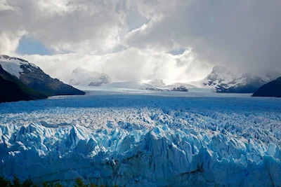
Los Glaciares National Park, Santa Cruz Province, Argentina

Los Glaciares National Park covers an area of 726,927 ha (7,269.27 km2; 2,806.68 sq mi), making it the largest national park in the country. Established on 11 May 1937,it hosts a representative sample of Magellanic sub polar forest and west Patagonian steppe biodiversity in good state of conservation. In 1981, it was declared a World Heritage Site by UNESCO.

The park's name refers to the giant ice cap in the Andes, the largest outside of Antarctica, Greenland and Iceland, feeding 47 large glaciers, of which 13 flow towards the Atlantic Ocean. In other parts of the world, glaciers start at a height of at least 2,500 m (8,200 ft) above mean sea level, but due to the size of the ice cap, these glaciers begin at only 1,500 m (4,900 ft), sliding down to 200 m (660 ft). Los Glaciares borders Torres del Paine National Park to the south in Chilean territory. 

Los Glaciares owes its name to the numerous glaciers covering roughly half of the World Heritage property. Many of these glaciers are fed by the massive South Patagonian Ice Field, the most extensive South American relict of the glaciological processes of the Quaternary Period. In addition, there are impressive glaciers independent of the main ice field. The property therefore constitutes a massive freshwater reservoir. The Upsala, Onelli and Perito Moreno Glaciers calve into the icy and milky waters of the huge Lake Argentino, which is partly included in the property. The most striking sight is the famous Perito Moreno Glacier. This large glacier blocks a narrow channel formed by Lake Argentino thereby raising the water level temporarily. This in turn causes regular thunderous ruptures of the glacier tongue into the lake.


The mountains hold most of the humidity from the Pacific Ocean, letting through only the ice coldness (annual average of 7.5 °C (45.5 °F)) and creating the arid Patagonian steppe on the Argentine side of the range. This area is habitat for ñandúes, guanaco, cougar, and South American gray fox, the latter of which has suffered from the invasion of the cattle industry and are endangered. The guanaco, while not endangered, has had a dramatic decline in historic population due to large scale grazing of livestock throughout much of Patagonia. There are over 100 species of birds in the area (condors, eagles, and others). Between the ice and the Patagonian steppe there is a fertile area of Magellanic subpolar forests composed mainly of lengas and guindos. Within these more hospitable areas also live huemul deer and torrent duck.

Los Glaciares is a major attraction for international tourists. Starting points of tours are the village of El Calafate at the shore of Lake Argentino but outside the park, where the park's administration has its headquarters, and El Chaltén village in the northern part of the park, at the foot of the Fitz Roy. Other touristic points in the park include Lago del Desierto and Lago Roca.

For more Information - Los Glaciares National Park

Feb 4, 2019

Salar de Uyuni (World's Largest Mirror), Andes in Southwest Bolivia

Salar de Uyuni or Salar de Tunupa is the world's largest salt flat, at 10,582 square kilometers (4,086 sq mi). It is in the Daniel Campos Province in Potosí in southwest Bolivia, near the crest of the Andes and is at an elevation of 3,656 meters (11,995 ft) above sea level.

The Salar was formed as a result of transformations between several prehistoric lakes. It is covered by a few meters of salt crust, which has an extraordinary flatness with the average elevation variations within one meter over the entire area of the Salar. The crust serves as a source of salt and covers a pool of brine, which is exceptionally rich in lithium. It contains 50% to 70% of the world's known lithium reserves. The large area, clear skies, and exceptional flatness of the surface make the Salar an ideal object for calibrating the altimeters of Earth observation satellites. Following rain, a thin layer of dead calm water transforms the flat into the world's largest mirror, 129 kilometers (80 miles) across. 

The Salar serves as the major transport route across the Bolivian Altiplano and is a major breeding ground for several species of flamingos. Salar de Uyuni is also a climatologist transitional zone since the towering tropical cumulus congest us and cumulonimbus incus clouds that form in the eastern part of the salt flat during the summer cannot permeate beyond its drier western edges, near the Chilean border and the Atacama Desert.
 
Salar is salt flat in Spanish. Uyuni originates from the Aymara language and means a pen (enclosure); Uyuni is a surname and the name of a town that serves as a gateway for tourists visiting the Salar. Thus Salar de Uyuni can be loosely translated as a salt flat with enclosures, the latter possibly referring to the "islands" of the Salar; or as "salt-flat at Uyuni


Salar de Uyuni is part of the Altiplano of Bolivia in South America. The Altiplano is a high plateau, which was formed during uplift of the Andes mountains. The plateau includes fresh and saltwater lakes as well as salt flats and is surrounded by mountains with no drainage outlets. The Salar contains a large amount of sodium, potassium, lithium and magnesium as well as borax. Of those, lithium is arguably most important as it is a vital component of many electric batteries. With estimated 9,000,000. The Bolivia holds about 43 % of the world's known lithium reserves; most of those are in the Salar de Uyuni

The area has a relatively stable average temperature with a peak at 21 °C in November to January and a low of 13 °C in June. The nights are cold all through the year, with temperatures between −9 °C and 5 °C. The relative humidity is rather low and constant throughout the year at 30% to 45%. The rainfall is also low at 1 mm to 3 mm per month between April and November, but it may increase up to 80 mm in January. However, except for January, even in the rainy season the number of rainy days is fewer than 5 per month and Every November, Salar de Uyuni is the breeding ground for three species of pink South American flamingo: the Chilean, Andean, and rare James's flamingos, their color presumably originating from feeding on pink algae. About 80 other bird species are present, including the horned coot, Andean goose, and Andean hillstar. The Andean fox, or culpeo, is also present, and islands in the Salar host colonies of rabbit-like viscachas

Salar de Uyuni attracts tourists from around the world. As it is far from the cities, a number of hotels have been built in the area. Due to lack of conventional construction materials, many of them are almost entirely (walls, roof, furniture) built with salt blocks cut from the Salar. The first such hotel, named Palacio de Sal, was erected in 1993–1995 in the middle of the salt flat, and soon became a popular tourist destination. However, its location in the center of a desert caused sanitation problems, as most waste had to be collected manually. Mismanagement caused serious environmental pollution and the hotel had to be dismantled in 2002. One major tourist attraction is an antique train cemetery. It is 3 km outside Uyuni and is connected to it by the old train tracks. The town served in the past as a distribution hub for the trains carrying minerals en route to Pacific Ocean ports. The rail lines were built by British engineers arriving near the end of the 19th century and formed a sizeable community in Uyuni. The engineers were invited by the British-sponsored Antofagasta and Bolivia Railway Companies, now Ferrocarril de Antofagasta a Bolivia. The rail construction started in 1888 and ended in 1892. It was encouraged by Bolivian President Aniceto Arce, who believed Bolivia would flourish with a good transport system, but it was also constantly sabotaged by the local Aymara indigenous Indians who saw it as an intrusion into their lives. The trains were mostly used by the mining companies. In the 1940s, the mining industry collapsed, partly because of mineral depletion. Many trains were abandoned, producing the train cemetery. There are proposals to build a museum from the cemetery.

Feb 3, 2019

The Marble Caves of Chile (Unique Places of the World), Chile Chico, Chile

The Marble Caves of Chile are sometimes called “the Marble Caverns,” “the Marble Cathedral,” or “the Marble Chapel.” Care should be used when using these other names because they may refer to other specific features within the marble caves. In the native tongue, the caves are known as “Cuevas de Mármol.”  

Aggressive waves have washed up against the marble (calcium carbonate) for years, and slowly shaped the curved walls. However, these strong walls of marble cave in Patagonia did not instantly mold into the unique structure you see today. This process has been occurring for over six centuries! Its smooth and vibrant walls are now a reflection of the lake’s azure waters, which often change in color depending on the water levels and time of year.

The caves are situated in the Patagonian Andes. More specifically, the Marble Caves are sitting on a peninsula of marble that borders Lake General Carrera (as it is called in Chile). The lake is shared by Chile and Argentina and is known as Lake Buenos Aires on the Argentinian side.


The uniqueness of the caves ranges from its formation to the spectacular beauty that it is today. The beauty that is found there has taken over 6,000 years. Furthermore, the caves glow a range of magical colors depending on the level of the water. The stones themselves do not glow. Instead, the water reflects a range of cerulean hues and intensities that create a magical and tantalizing effect. During spring, the shallow levels of water reflect a turquoise hue on the caves. The high levels of water during the summer brought about by glacial melting provide a deep cerulean blue hue. At times, the reflections may also be white, grey, or the occasional pink. While they may seem ordinary on the outside, they are anything but. The biggest threat to the caves is the water. The erosion that has shaped the caves may very well be its undoing in the future. The reason for this is because the erosion caused by the wave action is unchecked. The beautiful smooth pillars that make the caves stable may be completely eroded thus collapsing the beautiful feature. This argument becomes even more convincing while observing the feature from the outside. The topmost part looks bigger and heavier than the supporting bottom.

The area around the lake is a typical aquatic one full of fish (such as trout and salmon), plants, and other forms of aquatic life. The land around the lake is also lush with vegetation in the surrounding range. Generally, the weather around these parts of Chile and Argentina is humid and cold. However, the regions around the lake have their own micro climate of a sunny and warm nature.

The caves are a popular destination for tourists from all around the world. Nature lovers and photographers often frequent the site. The most popular period for tourism is usually between December and February. The caves are inaccessible by road and can only be reached by boat. Tourists board a boat from a nearby remote town known as Puerto Rio Tranquillo.