Dec 31, 2018

Crooked Forest (The mysterious), Northwest Poland

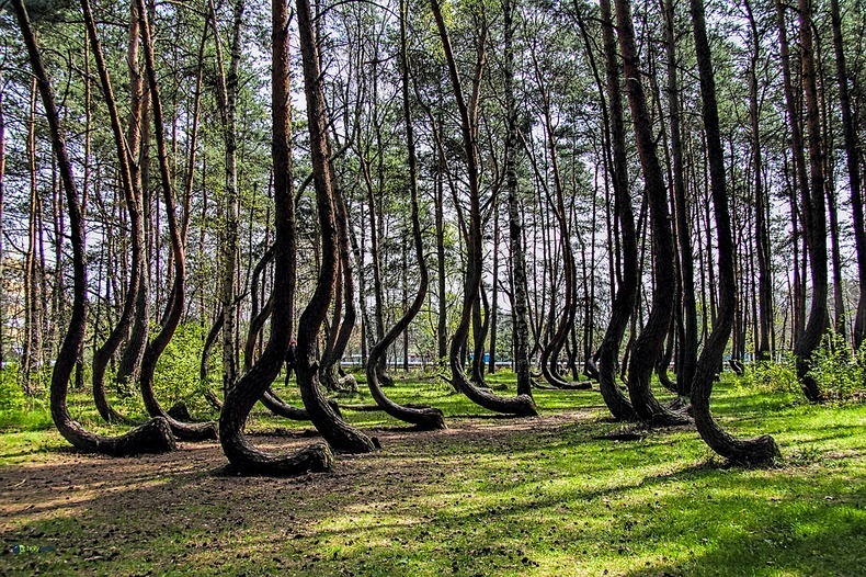
Crooked Forest  is the group of 400 pine trees in the northwest of Poland appear to be almost normal, but they are not. If you look at the base of these trees, you might feel like you’ve just entered a strange mystical fairy tale. All of the trees have the same northward 90-degree bend at the base of their limb. Known as the “Crooked Forest,” this unique site remains an unexplained mystery. Every tree in the Crooked Forest has the same haunting bend, but despite bent beginnings, all of the trees have grown to be tall and seemingly unhampered by their C shape curves. Some experts believe that the trees grew like this because they incurred some sort of damage to the tip and along some side branches.Trees are resilient, and so they continued to thrive, relying on the one branch they had left to take over complete function and grow upwards. Whatever damage occurred to one tree must have happened to them all because they remain uniform in deformity.


 The Crooked Forest is around 80 years old. It is estimated that the damage that made them look how they do today occurred when the trees were about 7 years old. This would have been before the Second World War reached Poland. Which helps to explain the most popular theory about how the trees came to be crooked. As the story goes, in 1930 a group of farmers planted these trees, intentionally damaging the base in order to create some sort of product, perhaps uniquely shaped furniture. The world may never know if it’s true because the farmers were unable to finish their work after the invasion on Poland during World War II dismantled their plans.It is likely the trees were formed like this to make furniture, ship mantels, or numerous other woodworking projects. After all it’s not unheard of to grow trees with a curve in the branch for certain wood-made parts. This practice produces what is known as “compass timbers.”

Even if that’s the reason these trees are now crooked, it still seems so odd and unexplained, simply because someone’s work was never completed. Others surmise that a snowstorm could have knocked the trees like this, freezing them into a bent position until the snow and ice melted come spring. The possibilities are truly endless when it comes to this unsolved mystery. There are plenty of trees in the area, all of which grow upright from the base without the funky curve distinct to the Crooked Forest clan. The Crooked Forest is an odd occurrence in a seemingly ordinary place. So perhaps you are wondering why none of the locals have answers to what caused the formation of the Crooked Forest.

This is likely because the local town was devastated during World War II. It wasn’t until the 1970’s, when a new power and heat plant came to the town that it began to reestablish itself. The Crooked Forest is located right near this power plant, known as Dolna Odra (‘Lower Oder’) power plant. Today tourists come to enjoy many beautiful natural sites common to this area—none of which happen to be as unexplainable as the Crooked Forest. If you are ever in Poland you can visit the 22 rows of oddly shaped trees. The Crooked Forest is located in a suburb called Gryfino in the Zachodniopomorskie province. One look at the forest and you start to imagine endless possibilities, so much history packed into the roots of these trees-if only trees could talk!

Mount Roraima (Hike to the top of the “Lost World”), South America

Mount Roraima is the highest of the Pakaraima chain of tepui plateaus in South America. First described by the English explorer Sir Walter Raleigh during his 1595 expedition, its 31-square-kilometre (12-square-mile) summit area is bounded on all sides by cliffs rising 400 metres (1,300 ft). The mountain also serves as the tripoint of Venezuela, Guyana and Brazil. Mount Roraima lies on the Guiana Shield in the southeastern corner of Venezuela's 30,000-square-kilometre (12,000-square-mile) Canaima National Park forming the highest peak of Guyana's Highland Range.

The highest point in Guyana and the highest point of the Brazilian state of Roraima lie on the plateau, but Venezuela and Brazil have higher mountains elsewhere. The triple border point is at 5°12′08″N 60°44′07″W, but the mountain's highest point is Laberintos del Norte. 
 
Many of the species found on Roraima are unique to the tepui plateaus with two local endemic plants found on Roraima summit. Plants such as pitcher plants, Campanula , and the rare Rapatea heather are commonly found on the escarpment and summit. It rains almost every day of the year. Almost the entire surface of the summit is bare sandstone, with only a few bushes and algae present. Low scanty and bristling vegetation is also found in the small, sandy marshes that intersperse the rocky summit. Most of the nutrients that are present in the soil are washed away by torrents that cascade over the edge, forming some of the highest waterfalls in the world.

There are multiple examples of unique fauna atop Mount Roraima. Oreophrynella quelchii, commonly called the Roraima Bush Toad, is a diurnal toad usually found on open rock surfaces and shrubland. It is a species of toad in the family Bufonidae and breeds by direct development. The species is currently listed as vulnerable and there is a need for increased education among tourists to make them aware of the importance of not handling these animals in the wild. Close population monitoring is also required, particularly since this species is known only from a single location. The species is protected in Monumento Natural Los Tepuyes in Venezuela, and Parque Nacional Monte Roraima in Brazil


Although the steep sides of the plateau make it difficult to access, it was the first recorded major tepui to be climbed: Sir Everard im Thurn walked up a forested ramp in December 1884 to scale the plateau. This is the same route hikers take today. A report by the noted South American researcher Robert Schomburgk inspired the Scottish author Arthur Conan Doyle to write his novel The Lost World about the discovery of a living prehistoric world full of dinosaurs and other primordial creatures.

The only non-technical route to the top is the Paraitepui route from Venezuela; any other approach will involve climbing gear. Mount Roraima has been climbed on a few occasions from the Guyana and Brazil sides, but as the mountain is entirely bordered on both these sides by enormous sheer cliffs that include high overhanging (negative-inclination) stretches, these are extremely difficult and technical rock climbing routes. Such climbs would also require difficult authorizations for entering restricted-access national parks in the respective countries.In Brazil the Monte Roraima National Park lies within the Raposa Serra do Sol Indigenous Territory, and is not open to the public without permission.

The 2013 Austrian documentary Jäger des Augenblicks - Ein Abenteuer am Mount Roraima (Moment Hunters - An Adventure on Mount Roraima) shows rock climbers Kurt Albert, Holger Heuber, and Stefan Glowacz climbing to the top of Mount Roraima from the Guyana side. Similarly, in 2010 Brazilian climbers Eliseu Frechou, Fernando Leal and Márcio Bruno opened a new route on the Guyanese side, climbing to the top in 12 days of a very difficult vertical wall climb.