Oct 22, 2013

Gypsies of The Sea (Floating Fishing Cities), China


Gypsies of The Sea are the wooden houses that are home to 7,000 'gypsies of the sea' who refuse to conform to modern living and want to remain on the ocean. This community in southeast China is home to 7,000 fishermen refusing to conform to modern lives, remaining in their traditional floating homes on the sea. The Tanka people, also called boat people or 'gypsies of the sea' can be traced back to the Tang Dynasty where local fishermen settled on their vessels to avoid wartime chaos on the mainland. The floating fishermen's village is located in Ningde City in southeast China’s Fujian province.


Before the founding of the Peoples Republic of China, the ‘gypsies of the sea’ were not allowed to go ashore or marry the people living along the beach. Everything from weddings to funeral ceremonies were instead held on the boats. In recent years, with the help of the local government, the fishermen have started to build houses along the shoreline. However, many of them prefer to still live out on the sea on their floating homes as is their people’s tradition.

Oct 12, 2013

Manassarovar lake (The Lake Of God), Tibet, People's Republic of China

Lake Manasarovar is a freshwater lake, near Mount Kailash in Tibet. Manasarovar Lake situated about 2000 kms from Lhasa. The lake is revered a sacred place in four religions: Buddhism, Hinduism and Jainism. According to Sanatan (Hindu) divine texts, its water has eternal power enabling personification of purity, and one who drinks water from the lake will go to the abode of Shiva after death. He is believed to be cleansed of all his sins committed over even a hundred lifetimes.
 
According to legend, Lake Manasasarovara is the lake in which a great Tibetan monk saw the letters "Aha", "Kha", " Mha". These three initials helped the search team to locate the current the 14th Dalai Lama of Tibet. The three initials stand for the province, the district, and the monastery in which the current Dalai Lama was born, i.e. Ahamdho, Khunbum, and Taktser respectively.


Lake Manasasarovar lies at 4,590 m (15,060 ft) above mean sea level, a relatively high elevation for a large freshwater lake on the mostly saline lake-studded Tibetan Plateau. Lake Manasasarovar is relatively round in shape with the circumference of 88 km (54.7 mi). Its depth reaches a maximum depth of 90 m (300 ft)[citation needed] and its surface area is 320 km2 (123.6 sq mi). It is connected to nearby Lake Rakshastal by the natural Ganga Chhu channel. Lake Manasasarovar is near the source of the Sutlej, which is the easternmost large tributary of the Sindhu. Nearby are the sources of the Brahmaputra River, the Indus River, and the Ghaghara, an important tributary of the Ganges.

Lake Manasasarovar overflows into Lake Rakshastal which is a salt-water endorheic lake. These lakes used to be part of the Sutlej basin and were separated due to tectonic activity.

The word "Manassarovara" originates from Sanskrit, which is a combination of the words "Manas" "sarovara" manas meaning mind and sarovara meaning lake. According to the Hindu religion, the lake was first created in the mind of the Lord Brahma after which it manifested on Earth. Like Mount Kailash, Lake Manas Sarovar is a place of pilgrimage, attracting religious people from India, Nepal, Tibet and the neighboring countries. Bathing in the Manas Sarovar and drinking its water is believed to cleanse all sins. Pilgrimage tours are organized regularly, especially from India, the most famous of which is the Kailash Manas Sarovar Yatra which takes place every year. Pilgrims come to take ceremonial baths in the cleansing waters of the lake.

Manassarovar lake has long been viewed by the pilgrims as being nearby to the sources of four of the greatest rivers of Asia, namely the Brahmaputra, Karnali, Indus and Sutlej. Thus it is an axial point which has been thronged to by pilgrims for thousands of years. The region was closed to pilgrims from the outside following the Chinese Invasion of Tibet; no foreigners were allowed between 1951 and 1980. After the 1980s it has again become a part of the Indian pilgrim trail.

For more Info - Manasarovar Lake

Nalanda (The Ancient International University) Bihar, India

Nalanda was an acclaimed Mahavihara, a large Buddhist monastery in the ancient kingdom of Magadha (modern-day Bihar) in India. The site is located about 95 kilometers (59 mi) southeast of Patna near the town of  Bihar Sharif, and was a centre of learning from the seventh century. It is a UNESCO World Heritage Site.

The highly formalized methods of Vedic learning helped inspire the establishment of large teaching institutions such as Taxila, Nalanda, and Vikramashila which are often characterized as India's early universities. Nalanda flourished under the patronage of the Gupta Empire in the 5th and 6th centuries and later under Harsha, the emperor of Kannauj. The liberal cultural traditions inherited from the Gupta age resulted in a period of growth and prosperity until the ninth century. The subsequent centuries were a time of gradual decline, a period during which the tantric developments of Buddhism became most pronounced in eastern India under the Pala Empire.

At its peak, the school attracted scholars and students from near and far with some traveling all the way from Tibet, China, Korea, and Central Asia. Archaeological evidence also notes contact with the Shailendra dynasty of Indonesia, one of whose kings built a monastery in the complex.


Much of our knowledge of Nalanda comes from the writings of pilgrim monks from East Asia such as Xuanzang and Yijing who travelled to the Mahavihara in the 7th century. Vincent Smith remarked that "a detailed history of Nalanda would be a history of Mahayanist Buddhism". Many of the names listed by Xuanzang in his travelogue as products of Nalanda are the names of those who developed the philosophy of Mahayana.  All students at Nalanda studied Mahayana as well as the texts of the eighteen (Hinayana) sects of Buddhism. Their curriculum also included other subjects such as the Vedas, logic, Sanskrit grammar, medicine and Samkhya.
Nalanda was very likely ransacked and destroyed by an army of the Mamluk Dynasty of the Muslim Delhi Sultanate under Bakhtiyar Khilji While some sources note that the Mahavihara continued to function in a makeshift fashion for a while longer, it was eventually abandoned and forgotten until the 19th century when the site was surveyed and preliminary excavations were conducted by the Archaeological Survey of India. Systematic excavations commenced in 1915 which unearthed eleven monasteries and six brick temples neatly arranged on grounds 12 hectares (30 acres) in area. A trove of sculptures, coins, seals, and inscriptions have also been discovered in the ruins many of which are on display in the Nalanda Archaeological Museum situated nearby. Nalanda is now a notable tourist destination and a part of the Buddhist tourism circuit.

For more details - Nalanda

Oct 5, 2013

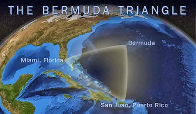
The Bermuda Triangle (Devil's Triangle), Western Part Of The North Atlantic Ocean

The Bermuda Triangle, also known as the Devil's Triangle, is a loosely-defined region in the western part of the North Atlantic Ocean, where a number of aircraft and ships are said to have disappeared under mysterious circumstances. Most reputable sources dismiss the idea that there is any mystery. The vicinity of the Bermuda Triangle is one of the most heavily traveled shipping lanes in the world, with ships frequently crossing through it for ports in the Americas, Europe, and the Caribbean islands. Cruise ships and pleasure craft regularly sail through the region, and commercial and private aircraft routinely fly over it.

Popular culture has attributed various disappearances to the paranormal or activity by extraterrestrial beings. Documented evidence indicates that a significant percentage of the incidents were spurious, inaccurately reported, or embellished by later authors.


In 1964, Vincent Gaddis wrote in the pulp magazine Argosy of the boundaries of the Bermuda Triangle, giving its vertices as Miami, San Juan, Puerto Rico, and Bermuda. Subsequent writers did not necessarily follow this definition. Some writers gave different boundaries and vertices to the triangle, with the total area varying from 1,300,000 to 3,900,000 km2 (500,000 to 1,510,000 sq mi).Consequently, the determination of which accidents occurred inside the triangle depends on which writer reported them. The United States Board on Geographic Names does not recognize the Bermuda Triangle.

The earliest suggestion of unusual disappearances in the Bermuda area appeared in a September 17, 1950, article published in The Miami Herald (Associated Press) by Edward Van Winkle Jones.Two years later, Fate magazine published "Sea Mystery at Our Back Door", a short article by George X. Sand covering the loss of several planes and ships, including the loss of Flight 19, a group of five US Navy Grumman TBM Avenger torpedo bombers on a training mission. Sand's article was the first to lay out the now-familiar triangular area where the losses took place. Flight 19 alone would be covered again in the April 1962 issue of American Legion magazine. In it, author Allan W. Eckert wrote that the flight leader had been heard saying, "We are entering white water, nothing seems right. We don't know where we are, the water is green, no white." He also wrote that officials at the Navy board of inquiry stated that the planes "flew off to Mars." Sand's article was the first to suggest a supernatural element to the Flight 19 incident. In the February 1964 issue of Argosy, Vincent Gaddis' article "The Deadly Bermuda Triangle" argued that Flight 19 and other disappearances were part of a pattern of strange events in the region. The next year, Gaddis expanded this article into a book, Invisible Horizons.

Lawrence David Kusche, author of The Bermuda Triangle Mystery: Solved (1975) argued that many claims of Gaddis and subsequent writers were often exaggerated, dubious or unverifiable. Kusche's research revealed a number of inaccuracies and inconsistencies between Berlitz's accounts and statements from eyewitnesses, participants, and others involved in the initial incidents. Kusche noted cases where pertinent information went unreported, such as the disappearance of round-the-world yachtsman Donald Crowhurst, which Berlitz had presented as a mystery, despite clear evidence to the contrary. Another example was the ore-carrier recounted by Berlitz as lost without trace three days out of an Atlanticport when it had been lost three days out of a port with the same name in the Pacific Ocean. Kusche also argued that a large percentage of the incidents that sparked allegations of the Triangle's mysterious influence actually occurred well outside it. Often his research was simple: he would review period newspapers of the dates of reported incidents and find reports on possibly relevant events like unusual weather, that were never mentioned in the disappearance stories.

Kusche concluded that:

  • The number of ships and aircraft reported missing in the area was not significantly greater, proportionally speaking, than in any other part of the ocean.
  • In an area frequented by tropical cyclones, the number of disappearances that did occur were, for the most part, neither disproportionate, unlikely, nor mysterious.
  • Furthermore, Berlitz and other writers would often fail to mention such storms or even represent the disappearance as having happened in calm conditions when meteorological records clearly contradict this.
  • The numbers themselves had been exaggerated by sloppy research. A boat's disappearance, for example, would be reported, but its eventual return to port may not have been.
  • Some disappearances had, in fact, never happened. One plane crash was said to have taken place in 1937, off Daytona Beach, Florida, in front of hundreds of witnesses; a check of the local papers revealed nothing.
  • The legend of the Bermuda Triangle is a manufactured mystery, perpetuated by writers who either purposely or unknowingly made use of misconceptions, faulty reasoning, and sensationalism.
For More Details - Bermuda Triangle

Uluru (Colour Changing Mountain), Kata Tjuta National Park, Australia

Uluru, also known as Ayers Rock and officially gazetted as "Uluru / Ayers Rock", is a large sandstone rock formation in the southern part of the Northern Territory in central Australia. It lies 335 km (208 mi) south west of the nearest large town, Alice Springs, 450 km (280 mi) by road.

Uluru is sacred to the Pitjantjatjara Anangu, the Aboriginal people of the area. The area around the formation is home to an abundance of springs, waterholes, rock caves and ancient paintings. Uluru is listed as a UNESCO World Heritage Site. Uluru and Kata Tjuta, also known as the Olgas, are the two major features of the Uluṟu-Kata Tjuṯa National Park.
On 19 July 1873, the surveyorWilliam Gosse sighted the landmark and named it Ayers Rock in honour of the then Chief Secretary of South Australia, Sir Henry Ayers. Since then, both names have been used. In 1993, a dual naming policy was adopted that allowed official names that consist of both the traditional Aboriginal name and the English name. On 15 December 1993, it was renamed "Ayers Rock / Uluru" and became the first official dual-named feature in the Northern Territory. The order of the dual names was officially reversed to "Uluru / Ayers Rock" on 6 November 2002 following a request from the Regional Tourism Association in Alice Springs


Uluru is one of Australia's most recognizable natural landmarks. The sandstone formation stands 348 m (1,142 ft) high, rising 863 m (2,831 ft) above sea level with most of its bulk lying underground, and has a total circumference of 9.4 km (5.8 mi). Both Uluru and the nearby Kata Tjuta formation have great cultural significance for the Aṉangu people, the traditional inhabitants of the area, who lead walking tours to inform visitors about the local flora and fauna, bush food and the Aboriginal dream time stories of the area.

Uluru is notable for appearing to change colour at different times of the day and year, most notably when it glows red at dawn and sunset. Kata Tjuta, also called Mount Olga or the Olgas, lies 25 km (16 mi) west of Uluru. Special viewing areas with road access and parking have been constructed to give tourists the best views of both sites at dawn and dusk.
Uluru is an inselberg, literally "island mountain". An inselberg is a prominent isolated residual knob or hill that rises abruptly from and is surrounded by extensive and relatively flat erosion lowlands in a hot, dry region. Uluru is also often referred to as a monolith, although this is a somewhat ambiguous term that is generally avoided by geologists. The remarkable feature of Uluru is its homogeneity and lack of jointing and parting at bedding surfaces, leading to the lack of development of scree slopes and soil. These characteristics led to its survival, while the surrounding rocks were eroded. For the purpose of mapping and describing the geological history of the area, geologists refer to the rock strata making up Uluru as the Mutitjulu Arkose, and it is one of many sedimentary formations filling the Amadeus Basin.

The development of tourism infrastructure adjacent to the base of Uluru that began in the 1950s soon produced adverse environmental impacts. It was decided in the early 1970s to remove all accommodation-related tourist facilities and re-establish them outside the park. In 1975, a reservation of 104 square kilometers0 (40 sq mi) of land beyond the park's northern boundary, 15 kilometers (9 mi) from Uluru, was approved for the development of a tourist facility and an associated airport, to be known as Yulara. The camp ground within the park was closed in 1983 and the motels closed in late 1984, coinciding with the opening of the Yulara resort. In 1992, the majority interest in the Yulara resort held by the Northern Territory Government was sold and the resort was renamed Ayers Rock Resort.

Since the park was listed as a World Heritage Site, annual visitor numbers rose to over 400,000 visitors by the year 2000. Increased tourism provides regional and national economic benefits. It also presents an ongoing challenge to balance conservation of cultural values and visitor needs. 
For More Details -  Uluru