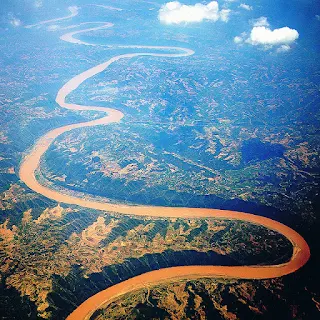
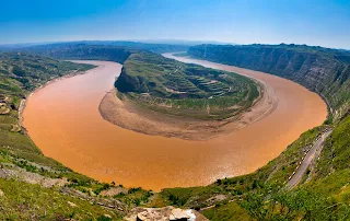
The Yellow River or Huang He is the second-longest river in Asia, following the Yangtze River, and the sixth-longest river system in the world at the estimated length of 5,464 km (3,395 mi). Originating in the Bayan Har Mountains in Qinghai province of western China, it flows through nine provinces, and it empties into the Bohai Sea near the city of Dongying in Shandong province. The Yellow River basin has an east–west extent of about 1,900 kilometers (1,180 mi) and a north–south extent of about 1,100 km (680 mi).
Its total basin area is about 742,443 square kilometers (286,659 sq mi). Its basin was the birthplace of ancient Chinese civilization, and it was the most prosperous region in early Chinese history. However, because of frequent devastating floods and course changes produced by the continual elevation of the river bed, sometimes above the level of its surrounding farm fields, it also has the names China's Sorrow and Scourge of the Sons of Han.
According to the China Exploration and Research Society, the source of the Yellow River is at 34° 29' 31.1" N, 96° 20' 24.6" E in the Bayan Har Mountains near the eastern edge of the Yushu Tibetan Autonomous Prefecture. The source tributuaries drain into Gyaring Lake and Ngoring Lake on the western edge of Golog Prefecture high in the Bayan Har Mountains of Qinghai. In the Zoige Basin along the boundary with Gansu, the Yellow River loops northwest and then northeast before turning south, creating the "Ordos Loop", and then flows generally eastward across the North China Plain to the Gulf of Bohai, draining a basin of 752,443 square kilometers (290,520 sq mi) which nourishes 140 million people with drinking water and irrigation.
The Yellow River passes through seven present-day provinces and two autonomous regions, namely (from west to east) Qinghai, Gansu, Ningxia, Inner Mongolia, Shaanxi, Shanxi, Henan, and Shandong. Major cities along the present course of the Yellow River include (from west to east) Lanzhou, Yinchuan, Wuhai, Baotou, Luoyang, Zhengzhou, Kaifeng, and Jinan. The current mouth of the Yellow River is located at Kenli County, Shandong. The river is commonly divided into three stages. These are roughly the northeast of the Tibetan Plateau, the Ordos Loop, and the North China Plain. However, different scholars have different opinions on how the three stages are divided.
The Yellow River passes through seven present-day provinces and two autonomous regions, namely (from west to east) Qinghai, Gansu, Ningxia, Inner Mongolia, Shaanxi, Shanxi, Henan, and Shandong. Major cities along the present course of the Yellow River include (from west to east) Lanzhou, Yinchuan, Wuhai, Baotou, Luoyang, Zhengzhou, Kaifeng, and Jinan. The current mouth of the Yellow River is located at Kenli County, Shandong. The river is commonly divided into three stages. These are roughly the northeast of the Tibetan Plateau, the Ordos Loop, and the North China Plain. However, different scholars have different opinions on how the three stages are divided.
The Yellow River is notable for the large amount of silt it carries—1.6 billion tons annually at the point where it descends from the Loess Plateau. If it is running to the sea with sufficient volume, 1.4 billion tons are carried to the sea annually.[citation needed] One estimate gives 34 kilograms of silt per cubic meter as opposed to 10 for the Colorado and 1 for the Nile.
Its average discharge is said to be 2,110 cubic meters per second (32,000 for the Yangtze), with a maximum of 25,000 and minimum of 245. However, since 1972, it often runs dry before it reaches the sea. The low volume is due to increased agricultural irrigation, increased by a factor of five since 1950. Water diverted from the river as of 1999 served 140 million people and irrigated 74,000 km² (48,572 mi²) of land. The Yellow River delta totals 8,000 square kilometers (3,090 mi²). However, with the decrease in silt reaching the sea, it has been reported to be shrinking slightly each year since 1996 through erosion.
The highest volume occurs during the rainy season from July to October, when 60% of the annual volume of the river flows. Maximum demand for irrigation is needed between March and June. In order to capture excess water for use when needed and for flood control and electricity generation, several dams have been built, but their expected life is limited due to the high silt load. A proposed South–North Water Transfer Project involves several schemes to divert water from the Yangtze River: one in the western headwaters of the rivers where they are closest to one another, another from the upper reaches of the Han River, and a third using the route of the old Grand Canal. Due to its heavy load of silt the Yellow River is a depositing stream – that is, it deposits part of its carried burden of soil in its bed in stretches where it is flowing slowly. These deposits elevate the riverbed which flows between natural levees in its lower reaches. Should a flood occur, the river may break out of the levees into the surrounding lower flood plain and take a new channel. Historically this has occurred about once every hundred years. In modern times, considerable effort has been made to strengthen levees and control floods
For more details - Yellow_River


No comments:
Post a Comment
Stay updated with our blog for more quality content! Your feedback is appreciated. Contact us at harshrex@outlook.com with any suggestions.