When the material was dated by the two radiocarbon laboratories in Oxford and California, it was established that the shoe dates back to 3,500 B.C. This date is a few hundred years older than the date given for the leather shoe found on Ötzi the Iceman, 400 years older than those found at Stonehenge, and 1,000 years older than those found at the Great Pyramid of Giza. After having been treated for preservation, the Areni-1 shoe is on display at the History Museum of Armenia, Yerevan.
The Amazing World Travel, We craft your experiences that inspire & transform your vacations to explore the world & wonders in a truly immersive and meaningful way, tailored just for you.
May 20, 2020
Areni-1 Shoe (The Oldest Leather Shoe In World), History Museum of Armenia, Yerevan, Armenia
When the material was dated by the two radiocarbon laboratories in Oxford and California, it was established that the shoe dates back to 3,500 B.C. This date is a few hundred years older than the date given for the leather shoe found on Ötzi the Iceman, 400 years older than those found at Stonehenge, and 1,000 years older than those found at the Great Pyramid of Giza. After having been treated for preservation, the Areni-1 shoe is on display at the History Museum of Armenia, Yerevan.
May 19, 2020
The Underwater Waterfall: A Natural Illusion in Mauritius
What Is the Underwater Waterfall?
The underwater waterfall is an optical illusion created by sand and silt sliding off an underwater shelf into the depths of the Indian Ocean. When viewed from above, especially from a helicopter or drone, this phenomenon looks like a vast cascade of water plunging into an abyss.
Location
- Where: The underwater waterfall is located off the coast of Le Morne Brabant, a UNESCO World Heritage Site in Mauritius.
- Geography: Le Morne Brabant is a peninsula surrounded by turquoise lagoons and coral reefs. Beyond the reef, the seabed drops steeply, contributing to the illusion.
How Does It Work?
Underwater Topography:
- The seabed near Le Morne Brabant features a steep drop-off, known as an ocean shelf. Beyond the shelf, the depth dramatically increases, creating an abyssal zone.
- Sand and silt naturally move along the ocean floor due to currents, giving the impression of cascading water.
Optical Illusion:
- The movement of sand and silt combines with the contrast between shallow, light-colored lagoon waters and the deep blue of the ocean to create the illusion of a waterfall.
- The effect is amplified when viewed from above, as sunlight enhances the varying colors of the water.
Why Is It Unique?
- Rare Phenomenon: While other underwater drop-offs exist, few create such a striking visual effect.
- Aerial Perspective: The illusion is best appreciated from the air, making helicopter tours a popular activity for visitors to Mauritius.
- Unspoiled Beauty: The pristine environment around Le Morne Brabant adds to the allure of the site, making it a top destination for nature lovers and photographers.
The Science Behind It
- Ocean Currents: The underwater currents around Mauritius are responsible for the constant movement of sand and silt, maintaining the illusion.
- Light Refraction: Differences in depth and water clarity cause light to refract differently, adding to the visual effect of flowing water.
Cultural and Historical Significance
- Le Morne Brabant:
- This mountain is a UNESCO World Heritage Site, recognized for its historical importance. It served as a refuge for runaway slaves in the 18th and 19th centuries.
- The underwater waterfall lies near this culturally rich landmark, tying natural beauty with human history.
- Mauritius Tourism:
- The underwater waterfall has become a symbol of Mauritius's natural wonders, attracting visitors from around the globe.
How to Experience the Underwater Waterfall
Helicopter Tours:
- Aerial tours offer the best view of the illusion. Operators in Mauritius provide guided flights that include this breathtaking feature.
- Flights often cover Le Morne Brabant, nearby lagoons, and the coral reef systems.
Boat Excursions:
- While the illusion is most dramatic from above, boat tours around the lagoon allow visitors to appreciate the turquoise waters and surrounding landscapes.
Scuba Diving and Snorkeling:
- Though the illusion cannot be seen underwater, the area offers excellent diving opportunities to explore coral reefs and marine life.
Environmental Considerations
- Marine Ecosystem:
- The area is part of a fragile marine ecosystem. The coral reefs surrounding Mauritius are home to diverse species of fish, turtles, and other marine organisms.
- Sustainable Tourism:
- Tourists are encouraged to respect the environment by avoiding damage to coral reefs and supporting eco-friendly tour operators.
Interesting Facts
- Misconceptions:
- Many believe the underwater waterfall is a real plunge of water into the depths. In reality, it’s entirely an optical illusion caused by natural factors.
- Geological Origins:
- Mauritius is a volcanic island, and the underwater shelf is a remnant of ancient lava flows that shaped the region millions of years ago.
- Iconic Photography Spot:
- The underwater waterfall is a favorite subject for aerial photographers, often featured in travel magazines and social media posts about Mauritius.
Conclusion
The underwater waterfall near Le Morne Brabant is a natural illusion that combines geology, oceanography, and visual artistry. It symbolizes the breathtaking beauty of Mauritius and serves as a reminder of the intricate interplay between nature’s elements. Whether you’re an adventurer, a photographer, or someone seeking awe-inspiring sights, the underwater waterfall is a must-see destination that will leave you spellbound.
May 18, 2020
The Panama Canal, Panama
The construction of the Panama Canal is where the expression "Another Day, Another Dollar" comes from, as the workers were rumored to be paid a dollar a day for their labor. France began work on the canal in 1881, but stopped because of engineering problems and a high worker mortality rate. The United States took over the project in 1904 and opened the canal on August 15, 1914. One of the largest and most difficult engineering projects ever undertaken, the Panama Canal shortcut greatly reduced the time for ships to travel between the Atlantic and Pacific oceans, enabling them to avoid the lengthy, hazardous Cape Horn route around the southernmost tip of South America via the Drake Passage or Strait of Magellan and the even less popular route through the Arctic Archipelago and the Bering Strait.
Colombia, France, and later the United States controlled the territory surrounding the canal during construction. The US continued to control the canal and surrounding Panama Canal Zone until the 1977 Torrijos–Carter Treaties provided for handover to Panama. After a period of joint American–Panamanian control, in 1999, the canal was taken over by the Panamanian government. It is now managed and operated by the government-owned Panama Canal Authority.
Annualtraffic has risen from about 1,000 ships in 1914, when the canal opened, to 14,702 vessels in 2008, for a total of 333.7 million Panama Canal/Universal Measurement System (PC/UMS) tons. By 2012, more than 815,000 vessels had passed through the canal. It takes 11.38 hours to pass through the Panama Canal. The American Society of Civil Engineers has ranked the Panama Canal one of the seven wonders of the modern world.
After World War II, US control of the canal and the Canal Zone surrounding it became contentious; relations between Panama and the United States became increasingly tense. Many Panamanians felt that the Canal Zone rightfully belonged to Panama; student protests were met by the fencing-in of the zone and an increased military presence there. Demands for the United States to hand over the canal to Panama increased after the Suez Crisis in 1956, when the United States used financial and diplomatic pressure to force France and the UK to abandon their attempt to retake control of the Suez Canal, previously nationalized by the Nasser regime in Egypt. Panamanian unrest culminated in riots on Martyr's Day, January 9, 1964, when about 20 Panamanians and 3–5 US soldiers were killed.
A decade later, in 1974, negotiations toward a settlement began and resulted in the Torrijos–Carter Treaties. On September 7, 1977, the treaty was signed by President of the United States Jimmy Carter and Omar Torrijos, de facto leader of Panama. This mobilized the process of granting the Panamanians free control of the canal so long as Panama signed a treaty guaranteeing the permanent neutrality of the canal. The treaty led to full Panamanian control effective at noon on December 31, 1999, and the Panama Canal Authority (ACP) assumed command of the waterway. The Panama Canal remains one of the chief revenue sources for Panama.
Before this handover, the government of Panama held an international bid to negotiate a 25-year contract for operation of the container shipping ports located at the canal's Atlantic and Pacific outlets. The contract was not affiliated with the ACP or Panama Canal operations and was won by the firm Hutchison Whampoa, a Hong Kong–based shipping interest owned by Li Ka-shing.
Initially the locks at Gatun were designed to be 28.5 m (94 ft) wide. In 1908, the United States Navy requested that an increased width of at least 36 m (118 ft) to allow the passage of US naval ships. Eventually a compromise was made and the locks were built 33.53 m (110.0 ft) wide. Each lock is 320 m (1,050 ft) long, with the walls ranging in thickness from 15 m (49 ft) at the base to 3 m (9.8 ft) at the top. The central wall between the parallel locks at Gatun is 18 m (59 ft) thick and over 24 m (79 ft) high. The steel lock gates measure an average of 2 m (6.6 ft) thick, 19.5 m (64 ft) wide, and 20 m (66 ft) high. Panama Canal pilots were initially unprepared to handle the significant flight deck overhang of aircraft carriers. USS Saratoga knocked over all the adjacent concrete lamp posts while passing through the Gatun Locks for the first time in 1928. It is the size of the locks, specifically the Pedro Miguel Locks, along with the height of the Bridge of the Americas at Balboa, that determine the Panamax metric and limit the size of ships that may use the canal. The 2006 third set of locks project has created larger locks, allowing bigger ships to transit through deeper and wider channels. The allowed dimensions of ships using these locks increased by 25 percent in length, 51 percent in beam, and 26 percent in draft, as defined by New Panamax metrics.
Despite having enjoyed a privileged position for many years, the canal is increasingly facing competition from other quarters. Because canal tolls have risen as ships have become larger, some critics have suggested that the Suez Canal is now a viable alternative for cargo en route from Asia to the US East Coast. The Panama Canal, however, continues to serve more than 144 of the world's trade routes and the majority of canal traffic comes from the "all-water route" from Asia to the US East and Gulf Coasts.
May 9, 2020
The Phi Phi Islands, Malacca Coast, Thailand
Phi Phi Don was initially populated by Muslim fishermen during the late-1940s, and later became a coconut plantation. The resident Thai population of Phi Phi Don remains more than 80 percent Muslim. The current population however if counting transient workers is more Buddhist than Muslim. The resident population is between 2,000 and 3,000 people (2013).
The islands came to worldwide prominence when Ko Phi Phi Le was used as a location for the 2000 British-American film The Beach. This attracted criticism, with claims that the film company had damaged the island's environment, as the producers bulldozed beach areas and planted palm trees to make it more resemble descriptions in the book, an accusation the film's makers contest. An increase in tourism was attributed to the film's release, which resulted in increased environmental degradation. Phi Phi Le is home to the "Viking Cave", where there is a thriving industry harvesting edible bird's nests. Ko Phi Phi was devastated by the Indian Ocean tsunami of December 2004, when nearly all of the island's infrastructure was destroyed.
There are two administrative villages on Ko Phi Phi under the administration of the Ao Nang sub-district, Mueang Krabi District, Krabi Province. There are nine settlements under these two villages.
The villages are:
Laem Thong ( between 300-500 people)
- Ban Ko Mai Phai (about 20 fishermen live on this island)
- Ban Laem Tong
- Ao Loh Bakhao
- Ao Lana
- Ao Maya (about 10 people, mostly in the ranger station)
- Ton Sai, the capital and largest settlement
- Hat Yao
- Ao Lodalum
- Laem Pho
The islands feature beaches and clear water, and the natural environment is protected by national park status. Tourism on the islands exploded since the release of the movie The Beach.
May 6, 2020
Rani ki Vav, Patan, Gujarat, India
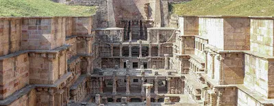
The finest and one of the largest example of its kind and designed as an inverted temple highlighting the sanctity of water, the stepwell is divided into seven levels of stairs with sculptural panels; more than 500 principle sculptures and over a thousand minor ones combine religious, mythological and secular imagery.
The stepwell was later flooded by the nearby Saraswati river and silted over. In 1890s, Henry Cousens and James Burgess visited it when it was completely buried under the earth and only well shaft and few pillars were visible. They called it huge pit measuring 87 metres (285 ft). In Travels in Western India, James Tod mentioned that the material from the stepwell was reused in the other stepwell built in modern Patan, probably Trikam Barot ni Vav (Bahadur Singh stepwell). In 1940s, the excavations carried out under the Baroda State revealed the stepwell. In 1986, the major excavation and restoration was carried out by the Archaeological Survey of India (ASI). An image of Udayamati was also recovered during the excavation. The restoration was carried out from 1981 to 1987.
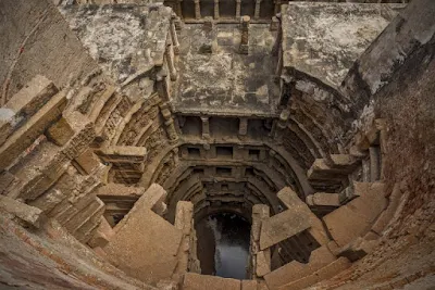
Rani ki vav is declared the Monument of National Importance and protected by the ASI. It was added to the list of UNESCO's World Heritage Sites on 22 June 2014. It was named India's "Cleanest Iconic Place" at the 2016 Indian Sanitation Conference. Rani ki vav is considered as the finest and one of the largest example of stepwell architecture in Gujarat. It was built at the height of craftsmens’ ability in stepwell construction and the Maru-Gurjara architecture style, reflecting mastery of this complex technique and beauty of detail and proportions. The architecture and sculptures is similar to the Vimalavasahi temple on Mount Abu and Sun temple at Modhera. It is classified as a Nanda-type stepwell. It measures approximately 65 metres (213 ft) long, 20 metres (66 ft) wide and 28 metres (92 ft) deep. The fourth level is the deepest and leads into a rectangular tank 9.5 metres (31 ft) by 9.4 metres (31 ft), at a depth of 23 metres (75 ft). The entrance is located in the east while the well is located at the westernmost end and consists of a shaft 10 metres (33 ft) in diameter and 30 metres (98 ft) deep. The stepwell is divided into seven levels of stairs which lead down to deep circular well. A stepped corridor is compartmentalized at regular intervals with pillared multistory pavilions. The walls, pillars, columns, brackets and beams are ornamented with carvings and scroll work. The niches in the side walls are ornamented with beautiful and delicate figures and sculptures. There are 212 pillars in the stepwell.
There are more than 500 principle sculptures and over a thousand minor ones combine religious, mythological and secular imagery, often referencing literary works. The ornamentation of stepwell depicts the entire universe inhabited by gods and goddesses; celestial beings; men and women; monks, priests and laity; animals, fishes and birds including real and mythical ones; as well as plants and trees.
The stepwell is designed as an underground shrine or inverted temple. It has spiritual significance and represents the sanctity of water. The sculptures in stepwell depicts numerous Hindu deities including Brahma, Vishnu, Shiva, goddesses (Devi), Ganesha, Kubera, Lakulisha, Bhairava, Surya, Indra and Hayagriva. The sculptures associated with Vishnu outnumbers all which include Sheshashayi Vishnu (Vishnu reclined on thousand hooded snake Shesha in the celestial ocean), Vishwarupa Vishnu (Cosmic form of Vishnu), twenty four forms as well as Dashavatara (ten incarnations) of Vishnu. The sculptures of deities with their families such as Brahma-Savitri, Uma-Maheshwar and Lakshmi-Narayan are there. Notable among other sculptures are Ardhanarishwara as well as large number of goddesses such as Lakshmi, Parvati, Saraswati, Chamunda, Durga/Mahishasurmardini with twenty hands, Kshemankari, Suryani and Saptamatrikas. There are images of Navagraha (nine plantets) as well.
There are a large number of celestial beings (Apsaras). One sculpture of Apsara depicts either applying lipstick to her lips or chewing on aromatic twig while a man is tickling her feet. On the northern side of the third storey pavilion, there is a sculpture of an Apsara warding off a monkey clinging to her leg and pulling at her clothes, revealing her seductive body. At her feet, there is a nude female with a snake around her neck probably representing an erotic motif. A sculpture of Nagkanya (serpent princess) with long hair and swan as well as sculptures of celestial dancers in classical dance positions are there.
There are large number of sculptures portraying women in their everyday life and activities. One sculpture depicts a woman combing her hair, adjusting her earring and looking herself in the mirror. Another sculptures include a woman writing a letter, a young woman with scorpion climbing her right leg and her clothes sliding off unknowingly, a young woman pulling a beard of a dwarf-like man, a woman with fish plate in her hands with a snake encircling her leg and reaching out to fish. One sculpture depicts a young women coming out of bath with her wet hair and a swan catching droplets of water falling from her hairs as if they are pearls. These women sculptures are adorned with jewelry including bangles, earrings, necklaces, waist girdles, anklets and others as well as with elegant clothes and well combed hairs. The variety of expressions and emotions are depicted in them. They represent beauty as well love in its sublime and seductive form signaling eroticism. There are sculptures representing maternal love such as a woman holding her child and pointing to moon to divert his attention, a woman raising her child high to let him pick a mango from tree, a woman in a mango grove with children with her.
There are gradually increasing cantilevered brackets in the well shaft which are profusely ornamented. There kalpavriksha carvings on the wall repents fertility and nature worship while kirtimukhas and makaras adorn the basements and capitals of pillars. On the northern side wall of entrance of the stepwell, there are geometric lattice patterns and designs resembling designs of local textile tradition of Patola. They may have been adapted from the wood carvings and the ceilings of the temples. Animal figures of horses, elephants and lions are used as decoration of pillars and basement moldings.


