Feb 22, 2013

The Village Cave, Turkey

The Village Cave is located among the "fairy chimney" rock formations, is a town in Cappadocia, a historical region of Turkey. It is in the Nevşehir Province in Central Anatolia and has a population of around 2,500 people.

Former names of the town have been Korama, Matiana, Maccan or Machan, and Avcilar. When Göreme Valley nearby was designated an important tourist destination, a "center" for all tourism in Cappadocia, the name of the town was changed to Göreme for practical reasons.


Among Göreme's historically important sites are Ortahane, Durmus Kadir, Yusuf Koc and Bezirhane churches, in addition to the richly decorated Tokali Kilise, the Apple Church, and a number of homes and pigeon houses carved straight into the rock formations in the town.

The Göreme National Park (Göreme Milli Parklar in Turkish) was added to the UNESCO World Heritage List in 1985. The location of Göreme was first settled back in the Roman period. Christianity was then the prevailing religion in the region, which is evident from many rock churches that can still be seen today. 

The Royal Rajasthan on Wheels, India

The Royal Rajasthan on Wheels is a luxury tourist train run by Indian Railways. It is modelled on the Palace on Wheels, and follows a similar route through Rajasthan. Tourists are taken to several important tourist, wildlife and heritage sites across Rajasthan. The luxury train was launched in January 2009 following the success of the Palace on Wheels, another luxury train that travels through Rajasthan.


The 14 luxury cabins housed within the Royal Rajasthan on Wheels have been named after some erstwhile royal palace of Rajasthan. Categorized into Deluxe and Super Deluxe saloons, these cabins come equipped with amenities such as Wi-Fi internet, Satellite TV, Channel music system and Individual temperature control. Deluxe saloons have three cabins Ruby.(the red color base theme cabin color, chair, curtain, bed cover.)Sapphire (the blue theme base color combination) and Pearl (the white base color cabin) Few cabin names are as follows: Hawa Mahal, Padmini Mahal, Kishori Mahal, Phool Mahal and Super Deluxe Coach Taj Mahal. have two cabins named Diamond and Emerald. Each cabin have the washroom having the shower cubicle and glass base washbasin give the royal experience. 
 
There are 2 dining cars in Royal Rajasthan on Wheels which are named Swarn Mahal (Gold Palace) and Sheesh Mahal'(Mirror palace). Whereas Swarn Mahal is patterned on brass and gold theme, the Sheesh Mahal restaurant features spectacular floor lamps and crystal pelmets. During the journey food will be served in the train, consisting of indian, continental, italian and chinese dishes. The indian cuisine contains Vegetarian and non vegetarian food, and also medicated food like sported beans are served in it. The delicious chicken and Laal Mass(Red meat) served during the tour, in which well dressed staff (Khidmatgar), who also serve tea, coffee and cookies (Biscuits), fruits and mineral water. The train also has a Royal kitchen to serve breakfast, lunch and dinner. A souvenir coach offers various handcrafter products and apparels which include beer mug, embossed leather jewelry product, cruet set, leather photo frame and various other accessories. A royal spa is latest addition in this luxury train amenities. 

The train takes tourists on a 7-day/8-night tour through Rajasthan. The train starts from New Delhi's Safdarjung railway station (Day 1), and has stops at Jodhpur (Day 2), Udaipur and Chittaurgarh (Day 3), Ranthambore National Park and Jaipur (Day 4), Khajuraho (Day 5), Varanasi and Sarnath (Day 6), Agra (Day 7) and back to Delhi (Day 8). Some of the tourist attractions covered are the Hawa Mahal (Palace of Winds), Moti Mahal, Sheesh Mahal, Ranthambhor National Park, Chittaurgarh Fort, Jag Niwas (Lake Palace), Keoladeo Ghana National Park, Agra Fort and finally the Taj Mahal.

The Ajanta Caves, Aurangabad, Maharashtra, India

The Ajanta Caves in Aurangabad district of Maharashtra state of India are about 29 rock-cut Buddhist cave monuments which date from the 2nd century BCE to about 480 or 650 CE. The caves include paintings and rock cut sculptures described as among the finest surviving examples of ancient Indian art, particularly expressive paintings that present emotion through gesture, pose and form.

According to UNESCO, these are masterpieces of Buddhist religious art that influenced Indian art that followed. The caves were built in two phases, the first group starting around the 2nd century BC, while the second group of caves built around 400–650 CE according to older accounts, or all in a brief period of 460 to 480 according to Walter M. Spink. The site is a protected monument in the care of the Archaeological Survey of India, and since 1983, the Ajanta Caves have been a UNESCOWorld Heritage Site.

The Ajanta Caves constitute ancient monasteries and worship halls of different Buddhist traditions carved into a 250 feet wall of rock. The caves also present paintings depicting the past lives and rebirths of the Buddha, pictorial tales from Aryasura's Jatakamala, as well as rock-cut sculptures of Buddhist deities in vogue between the 2nd century BCE and 5th century CE. Textual records suggest that these caves served as a monsoon retreat for monks, as well as a resting site for merchants and pilgrims in ancient India. While vivid colours and mural wall painting were abundant in Indian history as evidenced by historical records, Caves 16, 17, 1 and 2 of Ajanta form the largest corpus of surviving ancient Indian wall-painting.

The Ajanta Caves site are mentioned in the memoirs of several medieval era Chinese Buddhist travelers to India and by a Mughal era official of Akbar era in early 17th century. They were covered by jungle until accidentally "discovered" and brought to the Western attention in 1819 by a colonial British officer on a tiger hunting party. The Ajanta caves are located on the side of a rocky cliff that is on the north side of a U-shaped gorge on the small river Waghur, in the Deccan plateau. Further round the gorge are a number of waterfalls, which when the river is high are audible from outside the caves.

With the Ellora Caves, Ajanta is the major tourist attraction of Maharashtra. They are about 59 kilometres (37 miles) from the city of Jalgaon, Maharashtra, India, 60 kilometres (37 miles) from Pachora, 104 kilometres (65 miles) from the city of Aurangabad, and 350 kilometres (220 miles) east-northeast from Mumbai. They are 100 kilometres (62 miles) from the Ellora Caves, which contain Hindu, Jain as well as Buddhist caves, the last dating from a period similar to Ajanta. The Ajanta style is also found in the Ellora Caves and other sites such as the Elephanta Caves and the cave temples of Karnataka.


The Ajanta Caves are generally agreed to have been made in three distinct periods, the first belonging to the 2nd century BCE to 1st century CE, and second period that followed several centuries later. The caves consist of 36 identifiable foundations, some of them discovered after the original numbering of the caves from 1 through 29. The later identified caves have been suffixed with the letters of the alphabet, such as 15A identified between originally numbered caves 15 and 16. The cave numbering is a convention of convenience, and has nothing to do with chronological order of their construction.

The Ajanta Caves painting are a significant source of socio-economic information in ancient India. The Cave 1, for example, shows some Sassanian (or Persian) characters, as do other paintings that states Spink, are "filled with such foreign" looking types. This likely reflects merchants and visitors from the flourishing trade routes of that age.

The caves are carved out of flood basalt rock of a cliff, part of the Deccan Traps formed by successive volcanic eruptions at the end of the Cretaceous geological period. The rock is layered horizontally, and somewhat variable in quality. This variation within the rock layers required the artists to amend their carving methods and plans in places. The inhomogeneity in the rock have also led to cracks and collapses in the centuries that followed, as with the lost portico to cave 1. Excavation began by cutting a narrow tunnel at roof level, which was expanded downwards and outwards; as evidenced by some of the incomplete caves such as the partially-built vihara caves 21 through 24 and the abandoned incomplete cave 28.

The sculpture artists likely worked at both excavating the rocks and making the intricate carvings of pillars, roof and idols; further, the sculpture and painting work inside a cave were an integrated parallel tasks. A grand gateway to the site was carved, at the apex of the gorge's horseshoe between caves 15 and 16, as approached from the river, and it is decorated with elephants on either side and a nāga, or protective Naga (snake) deity. Similar methods and application of artist talent is observed in other cave temples of India, although many with very different themes such as those from Hinduism and Jainism. These include the Ellora caves, Ghototkacha caves, Elephanta Caves, Bagh Caves, Badami Caves and Aurangabad Caves. The caves from the first period seem to have been paid for by a number of different patrons to gain merit, with several inscriptions recording the donation of particular portions of a single cave. The later caves were each commissioned as a complete unit by a single patron from the local rulers or their court elites, again for merit in Buddhist afterlife beliefs as evidenced by inscriptions such as those in Cave 17. After the death of Harisena, smaller donors motivated by getting merit added small "shrinelets" between the caves or add statues to existing caves, and some two hundred of these "intrusive" additions were made in sculpture, with a further number of intrusive paintings, up to three hundred in cave 10 alone.
 
For More Details -  Ajanta Caves

Feb 21, 2013

Wadi-us-Salaam ( Largest Graveyard on Earth ), Shia Holy City of Najaf, Iraq

Wadi Al-Salam, meaning Valley of Peace in Arabic, is an ancient Islamic cemetery located near the holy city of Najaf, Iraq.  From an aerial view, it looks like a sprawling city.  However, its residents are not from the land of the living. This record-breaking cemetery contains approximately five millions bodies, making it the largest graveyard on earth.  With graves stretching as far as the eye can see, there are more tombs here than the population of most cities.  Ancient prophets, imams, kings, scientists, and civilians have been buried at this cemetery for close to 1,500 years and it is estimated that 500,000 bodies continue to be placed at the site each year, many of the more recent additions being soldiers and militants killed in fighting Daesh.


It is the largest cemetery in the world. The cemetery covers 1,485.5 acres (601.16 ha; 6.01 km2; 2.32 sq mi) and contains tens of millions of bodies. It also attracts millions of pilgrims annually.

The cemetery is located near the shrine of Imam Ali ibn Abi Talib, the fourth Sunni Caliph and the first Shia Imam. Thus, many Shi'ites in Iraq request that they be buried in this cemetery. As a result of improved transportation methods, Shi'ites from across the globe are (or seek to be) buried in the cemetery. However, burial at the cemetery "means being placed in one of the cemetery’s many catacombs." According to an undertaker at the cemetery, each crypt can hold up to 50 bodies. The burial plots are controlled by Marja'.

Shia tradition holds that Abraham bought land in Wadi-us-Salaam and that Ali said the Wadi Al-Salaam was a part of heaven. Shia also widely believe that Ali has the power to intercede for the deceased lessening their suffering during the passage of their soul from the worldly life and if they are buried there "they will be raised from the dead on judgment day with their spiritual leader."

The Shia are encouraged to bury their dead at the location through religious edicts and the cemetery's expansion is also seen as being a result of Shi'isms "more permissive attitude than Sunnism with regard to the commemoration of the dead and the erection of mausoleums."

Some rituals carried out before burial in the cemetery include: the body is washed and wrapped at the cemetery, the funeral prayers are conducted in the Imam Ali shrine, the deceased is carried around the shrine three times, and some Quranic verses are recited at the cemetery.

Daily burials have been on going for over 1,400 years and the site is on the Tentative List of UNESCO's World Heritage sites. Burials in Najaf have been documented as early as the Parthian and Sassanid eras and ancient Mesopotamian cities often had similar cemeteries, where there was an accumulation of tombs.

It is estimated that during the Iraq War about 200 to 250 corpses were buried there daily; however, in 2010 this number had decreased to less than 100. Approximately 500,000 new bodies are interred in the cemetery annually from across the globe. This figure is an increase on the approximately 20,000 bodies, primarily from Iran, that used to be interred annually in the early 20th century.  Most Iraqi and many Iranian Shi'ites have a relative buried in the cemetery.

Yellowstone National Park, Wyoming, Montana and Idaho, U.S

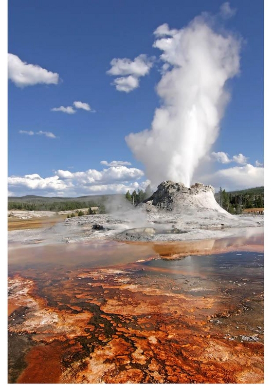
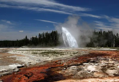
Yellowstone National Park is an American national park located in Wyoming, Montana, and Idaho. It was established by the U.S. Congress and signed into law by President Ulysses S. Grant on March 1, 1872. Yellowstone was the first national park in the U.S. and is also widely held to be the first national park in the world. The park is known for its wildlife and its many geothermal features, especially Old Faithful geyser, one of its most popular features. It has many types of ecosystems, but the sub alpine forest is the most abundant. It is part of the South Central Rockies forests Correggio.

Native Americans have lived in the Yellowstone region for at least 11,000 years. Aside from visits by mountain men during the early-to-mid-19th century, organized exploration did not begin until the late 1860s. Management and control of the park originally fell under the jurisdiction of the Secretary of the Interior, the first being Columbus Delano. However, the U.S. Army was subsequently commissioned to oversee management of Yellowstone for a 30-year period between 1886 and 1916. In 1917, administration of the park was transferred to the National Park Service, which had been created the previous year. Hundreds of structures have been built and are protected for their architectural and historical significance, and researchers have examined more than a thousand archaeological sites.

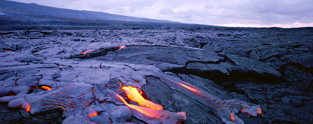
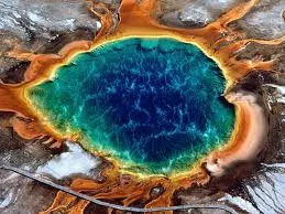
Yellowstone National Park spans an area of 3,468.4 square miles (8,983 km2), comprising lakes, canyons, rivers and mountain ranges.Yellowstone Lake is one of the largest high-elevation lakes in North America and is centered over the Yellowstone Caldera, the largest super volcano on the continent. The caldera is considered an active volcano. It has erupted with tremendous force several times in the last two million years. Half of the world's geysers and hydro thermal features are in Yellowstone, fueled by this ongoing volcanic. Lava flows and rocks from volcanic eruptions cover most of the land area of Yellowstone. The park is the centerpiece of the Greater Yellowstone Ecosystem, the largest remaining nearly-intact ecosystem in the Earth's northern temperate zone. In 1978, Yellowstone was named a UNESCO World Heritage Site.

Hundreds of species of mammals, birds, fish, and reptiles have been documented, including several that are either endangered or threatened. The vast forests and grasslands also include unique species of plants. Yellowstone Park is the largest and most famous mega fauna location in the contiguous United States. Grizzly bears, wolves, and free-ranging herds of bison and elk live in this park. The Yellowstone Park bison herd is the oldest and largest public bison herd in the United States. Forest fires occur in the park each year; in the large forest fires of 1988, nearly one third of the park was burnt. Yellowstone has numerous recreational opportunities, including hiking, camping, boating, fishing and sightseeing. Paved roads provide close access to the major geothermal areas as well as some of the lakes and waterfalls. During the winter, visitors often access the park by way of guided tours that use either snow coaches or snowmobiles.


Approximately 96 percent of the land area of Yellowstone National Park is located within the state of Wyoming. Another three percent is within Montana, with the remaining one percent in Idaho. The park is 63 miles (101 km) north to south, and 54 miles (87 km) west to east by air. Yellowstone is 2,219,789 acres (898,317 ha; 3,468.420 sq mi) in area, larger than the states of Rhode Island or Delaware. Rivers and lakes cover five percent of the land area, with the largest water body being Yellowstone Lake at 87,040 acres (35,220 ha; 136.00 sq mi). Yellowstone Lake is up to 400 feet (120 m) deep and has 110 miles (180 km) of shoreline. At an elevation of 7,733 feet (2,357 m) above sea level, Yellowstone Lake is the largest high altitude lake in North America. Forests comprise 80 percent of the land area of the park; most of the rest is grassland.

The Continental Divide of North America runs diagonally through the southwestern part of the park. The divide is a topographic feature that separates Pacific Ocean and Atlantic Ocean water drainage. About one third of the park lies on the west side of the divide. The origins of the Yellowstone and Snake Rivers are near each other but on opposite sides of the divide. As a result, the waters of the Snake River flow to the Pacific Ocean, while those of the Yellowstone find their way to the Atlantic Ocean via the Gulf of Mexico.

The park sits on the Yellowstone Plateau, at an average elevation of 8,000 feet (2,400 m) above sea level. The plateau is bounded on nearly all sides by mountain ranges of the Middle Rocky Mountains, which range from 9,000 to 11,000 feet (2,700 to 3,400 m) in elevation. The highest point in the park is atop Eagle Peak(11,358 feet or 3,462 meters) and the lowest is along Reese Creek (5,282 feet or 1,610 meters). Nearby mountain ranges include the Gallatin Range to the northwest, the Bear tooth Mountains in the north, the Absaroka Range to the east, and the Tetons Range and the Madison Range to the southwest and west. The most prominent summit on the Yellowstone Plateau is Mount Wash burn at 10,243 feet (3,122 m).

Yellowstone National Park has one of the world's largest petrified forests, trees which were long ago buried by ash and soil and transformed from wood to mineral materials. This ash and other volcanic debris are believed to have come from the park area itself. This is largely because Yellowstone is actually a massive caldera of a super volcano. There are 290 waterfalls of at least 15 feet (4.6 m) in the park, the highest being the Lower Falls of the Yellowstone River at 308 feet (94 m).

Three deep canyons are located in the park, cut through the volcanic tuff of the Yellowstone Plateau by rivers over the last 640,000 years. The Lewis River flows through Lewis Canyon in the south, and the Yellowstone River has carved two colorful canyons, the Grand Canyon of the Yellowstone and the Black Canyon of the Yellowstone in its journey north.

For more info, Plz visit -- Yellowstone National Park 

Hawaiʻi Volcanoes National Park (Island of Active Valcano), U.S. State, Hawaii

Hawaiʻi Volcanoes National Park, established in 1916, is a United States National Park located in the U.S. State of Hawaiʻi on the island of Hawaiʻi. It encompasses two active volcanoes: Kīlauea, one of the world's most active volcanoes, and Mauna Loa, the world's most massive volcano. The park gives scientists insight into the birth of the Hawaiian Islands and ongoing studies into the processes of vulcanism. For visitors, the park offers dramatic volcanic landscapes as well as glimpses of rare flora and fauna.

In recognition of its outstanding natural values, Hawaiʻi Volcanoes National Park was designated as an International Biosphere Reserve in 1980 and a World Heritage Site in 1987. In 2012 the Hawai'i Volcanoes National Park was honored on the 14th quarter of the America the Beautiful Quarters series.


The park includes 323,431 acres (505.36 sq mi; 1,308.88 km2) of land. Over half of the park is designated the Hawaii Volcanoes Wilderness area and provides unusual hiking and camping opportunities. The park encompasses diverse environments that range from sea level to the summit of the Earth's most massive active volcano, Mauna Loa at 13,677 feet (4,169 m). Climates range from lush tropical rain forests, to the arid and barren Kaʻū Desert.

The main entrance to the park is from the Hawaii Belt Road. The Chain of Craters Road, as the name implies, leads past several craters from historic eruptions to the coast. It used to continue to another entrance to the park near the town of Kalapana, but that portion is now covered by a lava flow.
 
The volcano became a tourist attraction in the 1840s, and local businessmen such as Benjamin Pitman and George Lycurgus ran a series of hotels at the rim. Volcano House is the only hotel or restaurant located within the borders of the national park.

Lorrin A. Thurston, grandson of the American missionary Asa Thurston, was one of the driving forces behind the establishment of the park after investing in the hotel from 1891 to 1904. William R. Castle first proposed the idea in 1903. Thurston, who then owned the Honolulu Advertiser newspaper, printed editorials in favor of the park idea. In 1907, the territory of Hawaii paid for fifty members of Congress and their wives to visit Haleakala and Kīlauea. It included a dinner cooked over lava steam vents. In 1908 Thurston entertained Secretary of the Interior James Rudolph Garfield, and in 1909 another congressional delegation. Governor Walter F. Frear proposed a draft bill in 1911 to create "Kilauea National Park" for $50,000. Thurston and local landowner William Herbert Shipman proposed boundaries, but ran into some opposition from ranchers. Thurston printed endorsements from John Muir, Henry Cabot Lodge, and former President Theodore Roosevelt. After several attempts, the legislation introduced by delegate Jonah Kūhiō Kalaniana'ole finally passed to create the park. House Resolution 9525 was signed by Woodrow Wilson on August 1, 1916. It was the 11th National Park in the United States, and the first in a Territory.

Within a few weeks, the National Park Service Organic Act would create the National Park Service to run the system. Originally called "Hawaii National Park", it was split from the Haleakalā National Park on September 22, 1961 (75 Stat. 577) to be formally known as Hawai`i Volcanoes National Park.

An easily accessible lava tube was named for the Thurston family. An undeveloped stretch of the Thurston Lava Tube extends an additional 1,100 ft (340 m) beyond the developed area and dead-ends into the hillside, but it is closed to the general public.

In 2004, an additional 115,788 acres (468.58 km2) of Kahuku Ranch were added to the park, making it 56% larger. This was an area west of the town of Waiʻōhinu and east of Ocean View, the largest land acquisition in Hawaii's history. The land was bought for US$21.9 million from the Samuel Mills Damon Estate, with financing from the Nature Conservancy. 

Several of the National Register of Historic Places listings on the island of Hawaii are located within the park: 
  • 1790 Footprints
  •  Ainahou Ranch
  • Ainapo Trail
  • Kilauea Crater
  • Puna-Ka'u Historic District
  • Volcano House
  • Whitney Seismograph Vault No. 29
  • Wilkes Campsite
The main visitor center, located just within the park entrance at 19°25′46″N 155°15′25.5″W, includes displays and information about the features of the park. The nearby Volcano Art Center, located in the original 1877 Volcano House hotel, is listed on the National Register of Historic Places and now houses historical displays and an art gallery.

The Thomas A. Jaggar Museum, located a few miles west on Crater Rim Drive, features more exhibits and a close view of the Kīlauea's active vent Halemaʻumaʻu. The museum is named after scientist Thomas Jaggar, the first director of the Hawaiian Volcano Observatory, which adjoins the museum. The observatory itself is operated by the U.S. Geological Survey and is not open to the public. Bookstores are located in the main visitor center and the Jaggar Museum. The Kilauea Military Camp provides accommodations for U.S. military person.